Shapley Heath Baseline Studies Fall Short of Cabinet Claims

In their defence of the Shapley Heath project debacle, Hart Cabinet have made a great deal of noise about the Baseline Studies produced by the developers as part of the project. The purpose of this post is to analyse the conclusions of those reports and come to a conclusion about their value.

The first point to note is that those reports have now been removed from Hart’s website. However, we did download them when they were available. Together they take up hundreds of MB of disk space. We have made them available here, on our Google drive for those who may wish to view them.

Summary of Results of the Shapley Heath Baseline Studies

Geo-Enviro Study

Low risk from past use, but calls for more detailed work. Glosses over landfill at Scotland Farm and Beggars Corner.

Transport

Proposes an impractical technocratic nirvana of bicycles, cargo-bikes and e-scooters with convoluted car journeys; Council should only consider “increases in highway capacity as a last resort”. Great way to wriggle out of infrastructure spending.

Landscape

Hundreds of pages of bumph, many simply repeating earlier studies in a massive appendix,  resulting in no conclusions except for a call for further work to “consider landscape value, sensitivity and capacity”.  In effect, totally useless.

Agricultural Land Classification

No specific report produced. One chart in the Landscape report. Was supposed to be extended into a detailed study, but apparently not produced.

Archaeological and Heritage

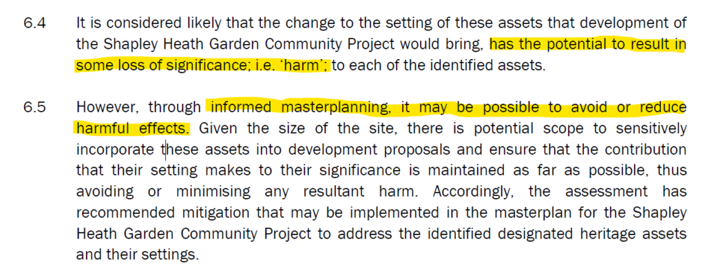
Concedes there would be harm to heritage assets, but claims “informed masterplanning” would avoid or reduce harm. More detailed work required.

Flooding and Drainage

Study concludes that there is a risk of fluvial (river), surface, reservoir and groundwater flooding across parts of the Area of Search. Recommends further work, particularly groundwater monitoring. Some pieces of evidence contradictory. Recommends areas prone to flood as “dry routes” out of the site.

Water Cycle/Management

No report produced.

Utilities

No report produced. It seems they’re ignoring the high pressure gas main and the high-voltage power lines.

Air Quality

Study admits the M3 is the biggest air quality constraint and that nearby SSSIs could be at risk. Apparently, air quality issues during the 16-year build phase are only temporary, so we don’t need to worry about them. Thankfully, they appear to have dropped the idea of building a tree-burning power plant.

Noise

Flawed study didn’t take account of increased traffic levels arising from the development. Admitted to needing an 80m buffer zone either side of the M3 and 20m from the A30 London Road. Concludes that “there are no planning or technical reasons with regard to noise to refuse the promotion of this site as a residential development”.

Contamination

No specific report produced

Ecology & Biodiversity Net Gain

Fairly useless report that documents the different habitat groups in the Area of Search and attributes biodiversity points to each one. Concludes with a statement of the bleeding obvious that to achieve a biodiversity net gain, there needs to be an increase in biodiversity. However, replacing any of the cropland or grassland with urban areas will automatically reduce biodiversity.

Ancient Woodland, Ancient and Veteran Trees

Useful report detailing all of the areas of ancient woodland and a schedule of 37 veteran trees. The report points out that development that might damage these areas be refused. It recommends buffer zones around the veteran trees of around 5m from the edge of the canopy and 15m from the ancient woodland.

Overall Status of Shapley Heath Baseline Studies

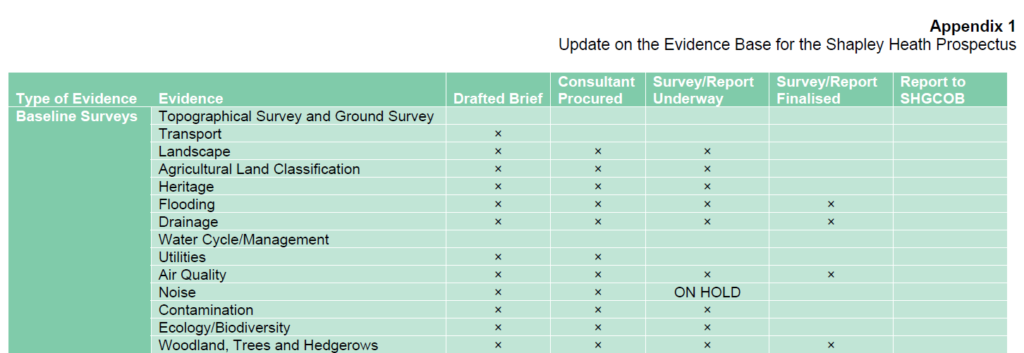
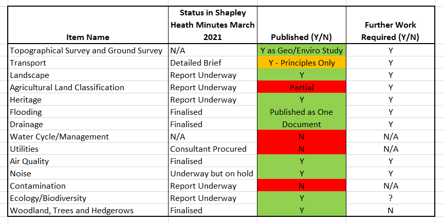
The Opportunity Board that took place in March 2021 promised no less than 14 Baseline Studies and showed the status of each at that time.

Status of Shapley Heath Baseline Studies as of March 2021

Status of Shapley Heath Baseline Studies as of March 2021

Despite claims by Cabinet that 10 studies have been produced, only 9 were published. However, one of them covered both Flood Risk and Drainage, so maybe we can say 10 of the promised subject areas were covered. It remains to be seen what happened to the other four.

Status of Shapley Heath Baseline Studies Falls Short of Expectations

Status of Shapley Heath Baseline Studies Falls Short of Expectations

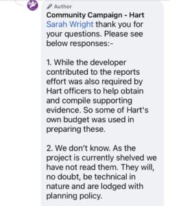
Interestingly, Community Campaign Hart have gone on record saying the have not read the documents. So, obviously they are total experts on the content of the reports and are well placed to judge their value 😉.

Questions about Shapley Heath Baseline Studies to CCH

Questions about Shapley Heath Baseline Studies to CCH

Answers about Shapley Heath Baseline Studies from CCH

Answers about Shapley Heath Baseline Studies from CCH.

Now let’s go through the details of each report.

Topographical and Ground Survey aka Geo-Enviro Desk Study

This was published as the Geo-Enviro desk study. The document was produced by Wardell Armstrong and is dated January 2021, despite the March status report showing no work had started. Note this is a desk based study; no actual field work has been carried out.

Geo-Enviro Study Objectives Wardell-Armstrong

Geo-Enviro Study Objectives.

They conclude that “site is considered to present an overall low risk from past use” and “the site is suitable for the proposed end use of residential and or commercial development with associated infrastructure”.

Geo-Enviro Study Low Risk from Past Use Wardell-Armstrong

Geo-Enviro Study Low Risk from Past Use

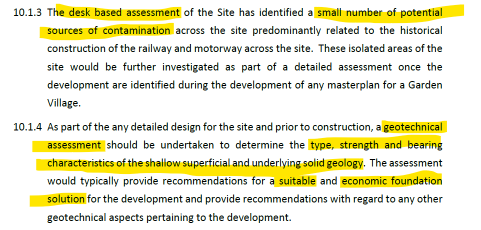
However, they go on to caveat their conclusions by stating that more detailed geotechnical work is required about the appropriate foundation solution for parts of the site.

Geo-Enviro Study Potential contamination Geotechnical Assessment Wardell-Armstrong

Geo-Enviro Study Potential contamination Geotechnical Assessment

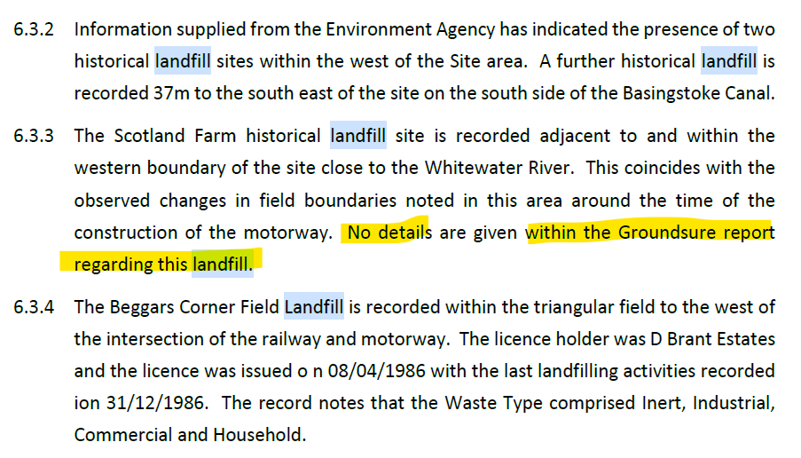
In the body of the paper they do note that Beggars Corner and Scotland Farm are former landfill sites, but gloss over the implications of this.

Geo-Enviro Study Potential Historic Landfill Beggars Corner Scotland Farm Wardell-Armstrong

Geo-Enviro Study Potential Historic Landfill Beggars Corner Scotland Farm

They also go on to note in their terms and conditions that they offer no guarantee  or warranty on their findings.

Geo-Enviro Study Potential No Guarantee or Warranty Wardell-Armstrong

Geo-Enviro Study Potential No Guarantee or Warranty

Shapley Heath Baseline Studies – Transport

Summary

The Transport Studies consist on seven “Topic Papers” delivered via email from the Steer Group. They are a triumph of technocratic idealism over common sense.

In their nirvana, everyone will ride bicycles or e-scooters so there’s no need to make a significant investment in roads.  The Council should abandon the philosophy of “Predict and Provide” and in favour of “Decide and Provide”, or rather don’t provide. They elaborate on this saying “user hierarchy putting pedestrians and cyclists first and motor traffic last, and design features including limited and well-placed car parking”.

This means that the Council should:

  • Simply “decide” the “preferred future” and provide for that future instead. SO, they can decide not to provide proper road infrastructure.
  • Actively seek to add “convoluted car journeys”.
  • Not try to predict the future traffic flows arising from 5-10,000 additional houses.
  • Only be “considering increases in highway capacity as a last resort”.
  • Include only limited parking facilities.
  • Assume everyone is going to cycle or take their lives in their hands on an e-scooter, instead of driving to do their big shop at the supermarket.
  • Not bother working out the costs of transport improvements.

In other words, they have decided that they will aim for an impractical technocratic nirvana so there’s no need to cost out a practical solution.

More Walking and Cycling Routes Plus Cargo Cycles

The aims of providing more walking and cycling routes are laudable. The roads around the proposed site notably lack pavements in  most places and there are almost no dedicated cycle paths.  However, there are some completely ridiculous ideas such as “freight to be transported by cargo cycles”. I don’t think any new supermarket would be happy to be restocked by a fleet of “cargo cycles”.

Shapley Heath Transport Study e-cargo bikes

Shapley Heath Transport Study e-cargo bikes

Convoluted Car Journeys

They also propose to “create more convoluted journeys for private vehicles thereby reducing propensity for short distance car trips”. In other words design the environment so it is difficult for cars to get in, through and out of the new development. This is a recipe for more congestion and poor quality of life. It is fundamental to economic efficiency and vibrant social life that it is easy for people to go where they want, when they want. The thing about private cars is that they promote freedom of movement and convenience. They seem to want to “Decide” that new residents should live the lives of Trappist Monks, never leaving the new town and not having visitors.

Shapley Heath Transport Study e-scooters and convoluted car journeys

Shapley Heath Transport Study e-scooters and convoluted car journeys

Better Public Transport

They also call for more busses. However, if the No. 7 bus service that already goes through Hartley Wintney is any guide, there is precious little demand for this mode of transport. By observation, these busses often have no passengers at all, and never more than a handful. It is difficult to see how this will change even with 5-10,000 extra houses.

The papers also call for more train journeys. However, they acknowledge that pre-pandemic the line was operating at maximum capacity. They outline a series of improvements that are planned for the Wessex line. However, it isn’t clear whether any of them will improve capacity or enhance services from Winchfield.

Ignoring EVs Eliminate Tail Pipe Emissions

Part of their rationale for strongly discouraging car use is to cut tail-pipe emissions. They fail to understand that by 2030 all new cars sold will be EVs, with no tailpipe emissions. Even now, hybrids are taking an ever increasing share of the market, so CO2 emissions are already falling in urban areas. It can be seen that their  rationale for reducing car usage  completely falls away.

No Costing

None of the Topic Papers addresses the costs of even providing footpaths and cycle paths. Of course they don’t address the cost of road improvements because they should only be “considering increases in highway capacity as a last resort”. In other words, they have decided that they will aim for an impractical technocratic nirvana so there’s no need to cost out a practical solution.

Landscape Character Assessment

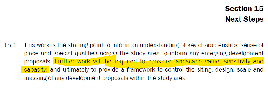
The Environmental Dimension Partnership (EDP) have produced hundreds of pages of bumph resulting in no conclusions. Much of the report is a massive appendix of earlier work carried out for the Council. They conclude by calling for further work to “consider landscape value, sensitivity and capacity”.  In effect, totally useless. The work is nowhere near as good as the work carried out by Michelle Bolger on behalf of Winchfield Parish Council.

Shapley Heath Landscape Study Further work required

Shapley Heath Landscape Study Further work required

Archaeological and Heritage Study

This is an 87-page report produced again by EDP. The report concedes that heritage assets would suffer “harm” as a result of such a significant development. However, they contend that with “informed masterplanning, it may be possible to avoid or reduce harmful effects”. Note the “may”.

Shapley Heath Archaeological and Heritage Study

Shapley Heath Archaeological and Heritage Study – Harm to heritage assets

Of course, they say more work is required, including actually visiting the site! Got to keep those consultancy fees rolling in.

Shapley Heath Baseline Studies – Flooding and Drainage

The Flooding and Drainage studies were produced as one document by Wardell-Armstrong who also produced the ge0-enviro desk study. This is an 68-page document plus three appendices. One plus point is that the various flood events documented on this website are incorporated into the evidence base.


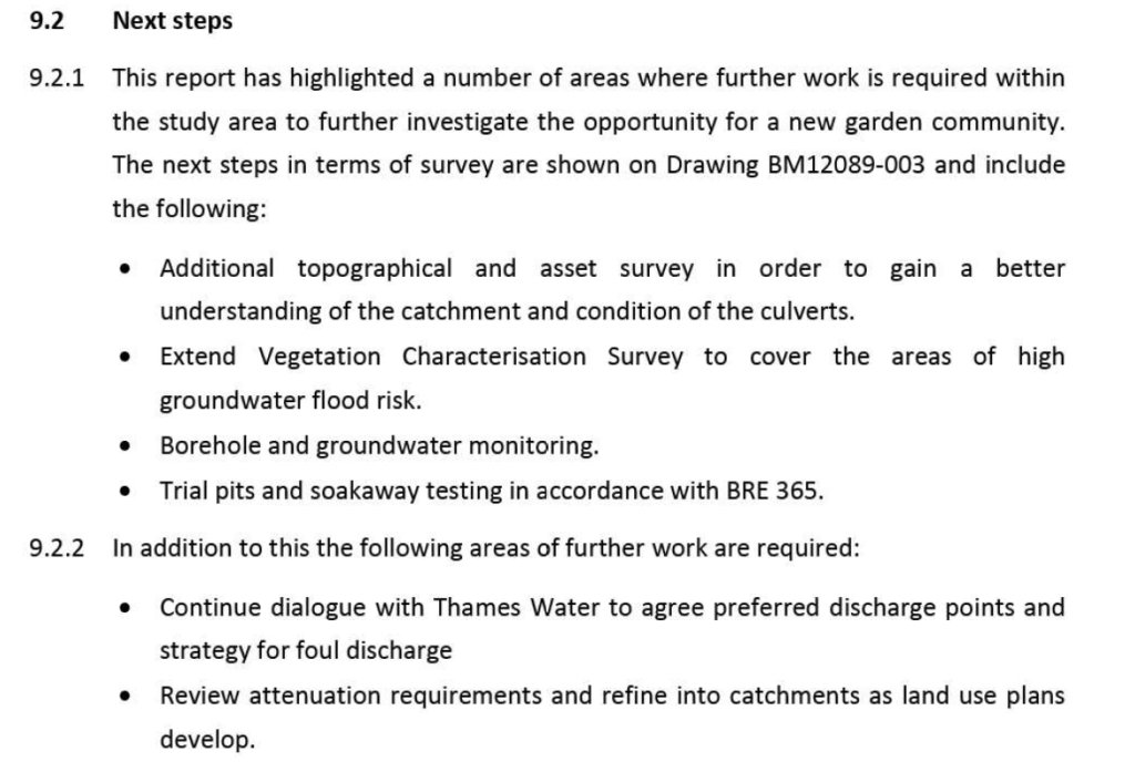
The main document shows that there is a risk of fluvial (river), reservoir, surface water and groundwater flooding across large parts of the site. It recommends further work to better quantify the risks and work out the mitigation.

Shapley Heath Flood Risk Study Additional Work Programme

Shapley Heath Flood Risk Study Additional Work Programme

In particular, a 12-month borehole study is recommended.

Shapley Heath Flood Risk Study 12 month borehole study required

Shapley Heath Flood Risk Study 12 month borehole study required

Given the project has been cancelled and no budget is currently allocated, it isn’t clear when or if this work will take place.

It is worth noting that significant parts of the evidence base are self-contradictory.

Surface Water Contradictions

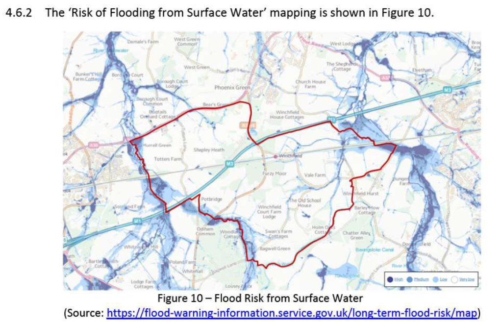
The first point to note is that they provide a very low quality image of the parts of the Area of Search that are subject to surface water risk.

Shapley Heath Flood Risk Study Figure 10 Surface Water

Shapley Heath Flood Risk Study Figure 10 Surface Water

At first glance, it looks like pretty much the whole site is clear of surface water flood risk.

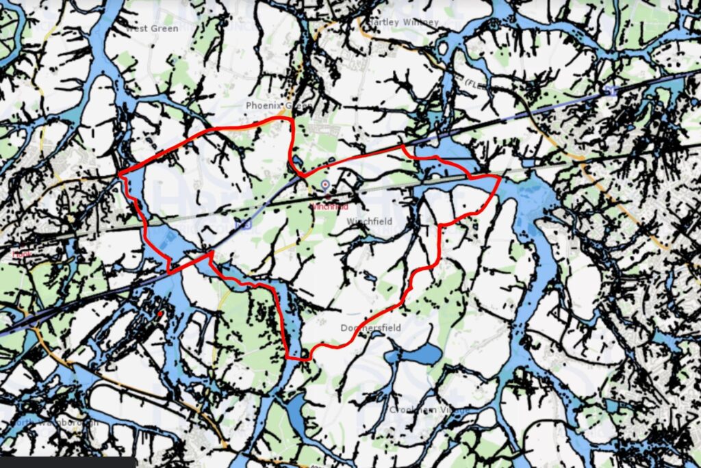
However, if you superimpose the Area of Search on Hart’s own map of surface water flood risk, a very different picture emerges.

Shapley Heath Surface Water Flood Risk from Hart Council Maps

Shapley Heath Surface Water Flood Risk from Hart Council Maps

Large swathes of the Area of Search is subject to surface water flood risk. An addendum to Hart’s own Strategic Flood Risk Assessment states that their various models of surface water flood risk underestimate the extent of flooding.

Models Underestimate Surface Water Flood Risk

Models Underestimate Surface Water Flood Risk

Clearly, more work is required on this subject.

Groundwater Contradictions

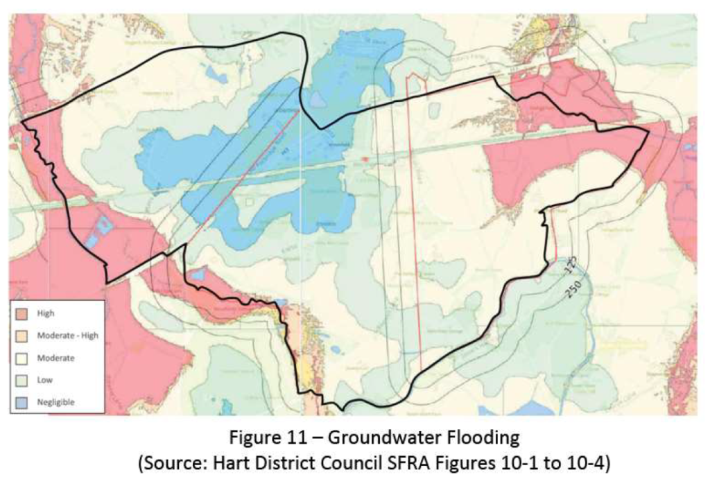
They use two different charts to illustrate the risk of groundwater flooding. The first shows high risk to the North East of the site and negligible risk across the central belt.

Shapley Heath Flood Risk Study Figure 11 Groundwater Flood Risk

Shapley Heath Flood Risk Study Figure 11 Groundwater Flood Risk

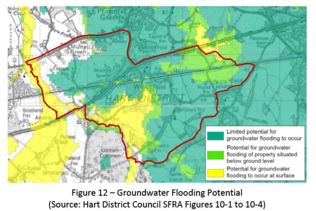
The second map shows high risk to the south, medium risk in the north east and low (note not negligible) across most of the rest of the site.

Shapley Heath Flood Risk Study Figure 12 Groundwater Flood Risk

Shapley Heath Flood Risk Study Figure 12 Groundwater Flood Risk

No wonder they called for the 12 month borehole study to work out what the real risks are.

Exit Route contradictions

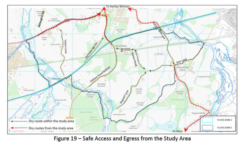
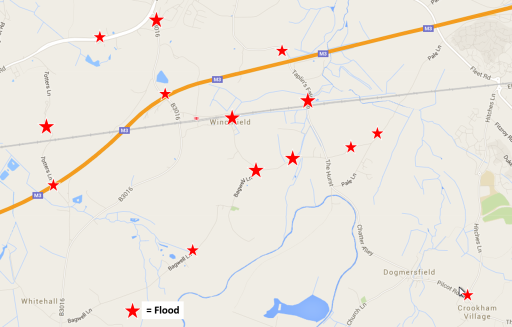
As part of their mitigation strategy, they identify a number of “dry routes” out of the site. These include Taplins Farm Lane, Station Road, Bagwell Lane and Totters Lane. The very roads that we have documented flood frequently and often to such an extent that they are impassable. They even reproduced the graphic below in their own document.

Shapley Heath Flood Risk Study Allegedly Dry Routes

Shapley Heath Flood Risk Study Allegedly Dry Routes

Winchfield, Hook, Crookham Village Floods 3 January 2016

Winchfield, Hook, Crookham Village Floods 3 January 2016

Clearly, they need to think again.

Shapley Heath Baseline Studies – Air Quality

Wardell-Armstrong have produced another 15-page report. However, the report is next to useless because there are no monitoring stations within the boundary of the Area of Search.

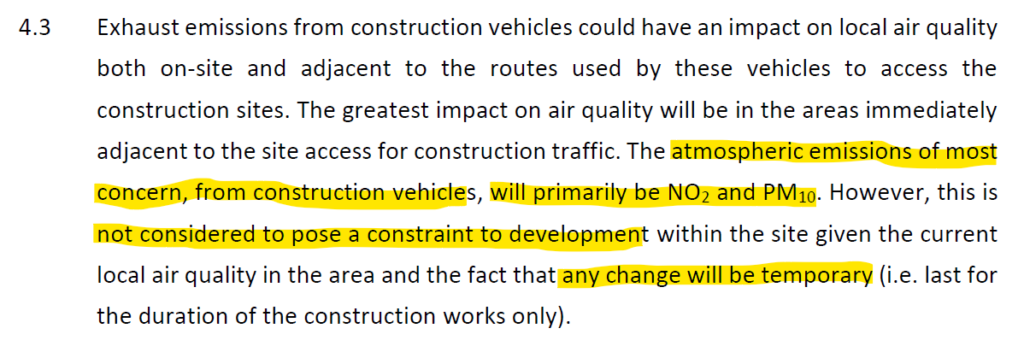
They do have a section on potential air quality impacts. They dismiss concerns about any impacts during construction as only “temporary.

Shapley Heath Air Quality Study Temporary Impacts during 16 year construction phase

Shapley Heath Air Quality Study Temporary Impacts during 16 year construction phase

However, the bid documentation suggested a building trajectory of 16 years. This hardly fits most people’s definition of temporary.

Shapley Heath Housing Trajectory Sept 2020

Shapley Heath Housing Trajectory Sept 2020

They then move on to the “operation” phase, by which they mean the impact on air quality having built 5-10,000 extra houses.

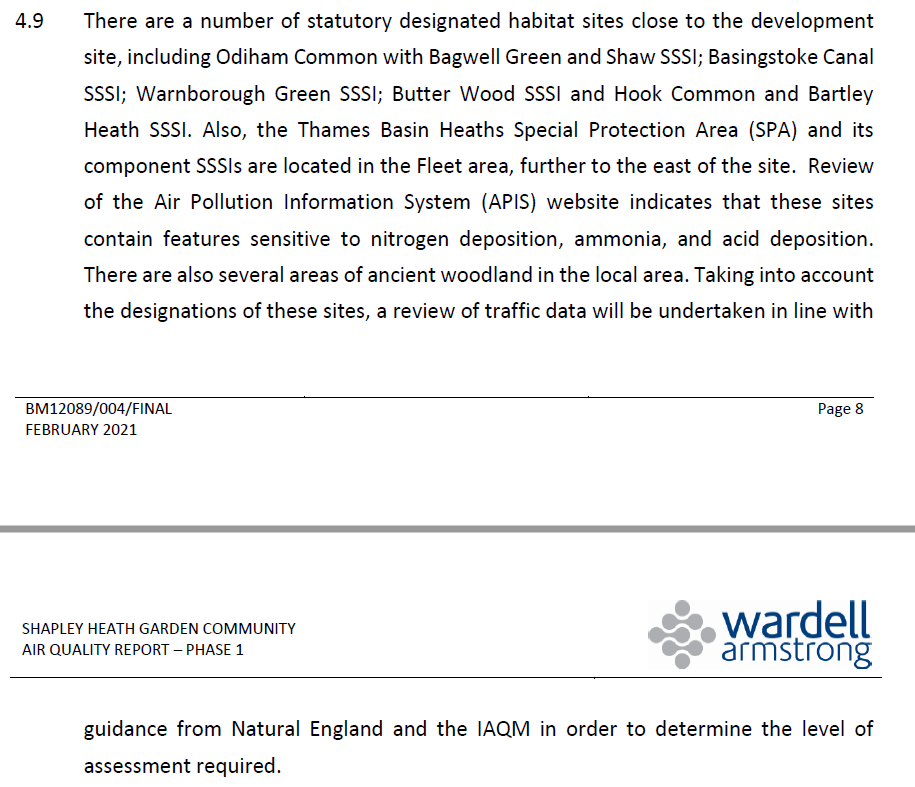
They concede that there could be potential damage to nearby SSSI’s, although they do not mention the many SINCs within the Area of Search.

Shapley Heath Air Quality Study Potential Damage to SSSIs during operation

Shapley Heath Air Quality Study Potential Damage to SSSIs during operation

They also admit that the M3 is “the most notable constraint” regarding air quality.

Shapley Heath Air Quality - M3 Is A Significant Constraint

Shapley Heath Air Quality – M3 Is A Significant Constraint

Thankfully, they have given up on the idea of a tree-burning biomass power plant or CHP as they euphemistically call it. In a previous Sustainability Appraisal they used the potential of such a plant to rank Shapley Heath above other options. Heaven knows why, burning wood to produce power generates more CO2 and noxious particulate emissions than burning coal.

Shapley Heath Air Quality - Given up on idea of a Power Plant

Shapley Heath Air Quality – Given up on idea of a Power Plant

Of course they need to do further more detailed work.

Shapley Heath Baseline Studies – Noise

Our friends at Wardell Armstrong have been busy again, this time on a 39-page Noise Assessment report. However, we believe this assessment to contain a very significant flaws:

  1. Study Timing.
  2. No account was taken of the extra traffic generated by the development.
  3. They assumed the development would be residential only.

Study Timing

First, the study was carried out in mid-June 2021. They assumed traffic levels were back to normal levels. However, some Covid restrictions were still in place up to mid-July 2021.

Shapley Heath Noise Study - Study period 9-14 June 2021

Shapley Heath Noise Study – Study period 9-14 June 2021

In addition, the study period was 9-14th June 2021. The 12th of June was a Saturday and the 13th was a Sunday. Weekends generally have lower traffic levels, so some of the readings they took will understate the mid-week noise levels.

Extra Traffic Ignored

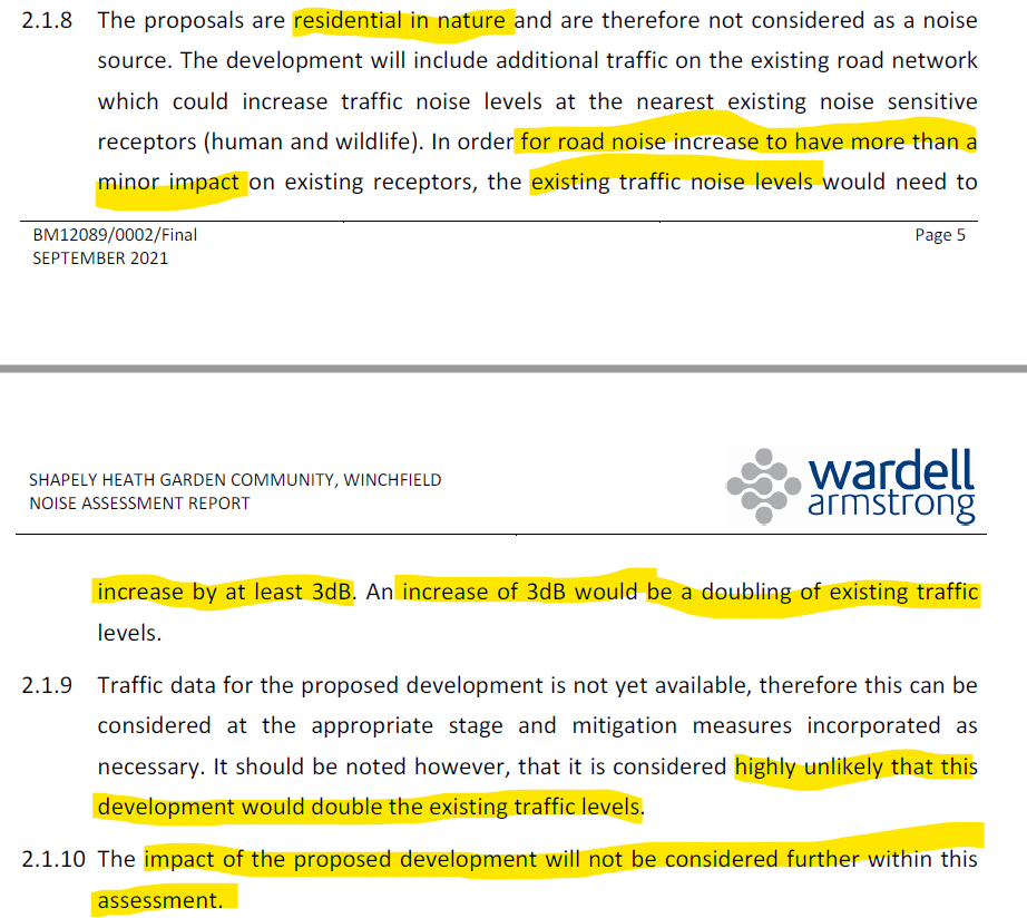
The extra traffic that will be generated by the development was not considered in their work. They justify this by saying traffic volumes would have to double to generate a 3dB increase in noise levels.

Shapley Heath Noise Study - Will Not Consider Impact of Proposed Development

Shapley Heath Noise Study – Will Not Consider Impact of Proposed Development

For a road like the M3, that is justifiable. For the A30 London Road, that assumption is at least debatable as it is likely to be one of the major access points should the development go ahead. Therefore, traffic volumes will likely rise significantly. However, for the more minor roads such as the B3016, Station Road, Bagwell Lane and Taplins Farm Lane, this assumption is demonstrably false. There’s currently only a couple of hundred dwellings in Winchfield. Increasing that by 5-10,000 would likely increase traffic on these minor roads by at least an order of magnitude, far more than double. Yet, they have chosen to ignore this obvious fact, despite designing the place to have “convoluted” car journeys adding to congestion and noise.

Assumed Residential Only

Moreover, they also assume that the development would be residential only. However, Hart’s own Project Overview document made it clear that the development would be mixed use, with various employment sites, supermarkets/retail and schools. These types of development will add further to the noise problem.

Shapley Heath Project Overview - Mixed Use Community with Employment and Retail premises

Shapley Heath Project Overview – Mixed Use Community with Employment and Retail premises

Noise Mitigation Strategy

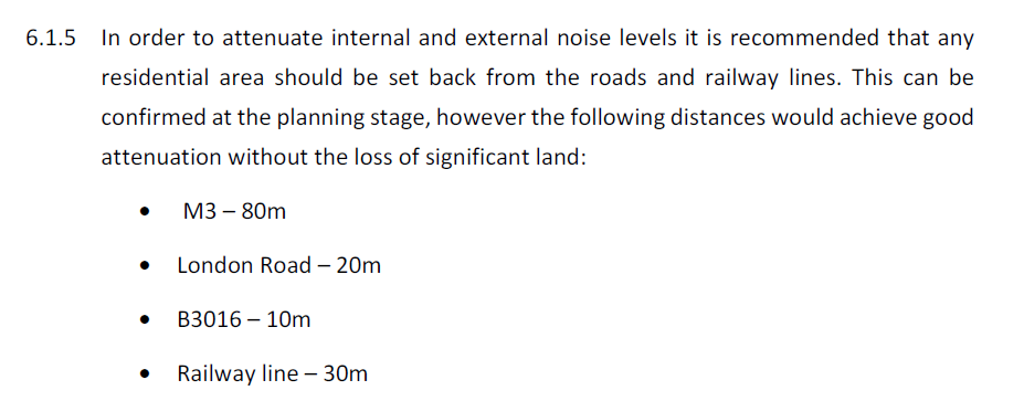
To mitigate the impact they recommend buffer zones around various roads and the railway. These include 80m from the M3, 20m from the A30 and 30m from the railway. We suspect the 10m buffer recommended around the B3016 will prove to be inadequate because traffic levels will rise very significantly.

Shapley Heath Noise Study - Road and Rail Buffer Zones

Shapley Heath Noise Study – Road and Rail Buffer Zones

However, as highlighted above, they have assumed zero extra traffic impact on Station Road, Bagwell Lane and Taplins Farm Lane. Therefore additional buffer zones maybe required. Such a buffer zone would reduce the land available for building, particularly on the parcel of land bounded by the B3016, the M3, Taplins Farm Lane and the railway.

They also recommend various other mitigation strategies such as 2m high fences, special glass in some windows near the major noise sources and “acoustic ventilation” so there’s no need to open windows.

The report concludes that if appropriate mitigation measures are put in place, “there are no planning or technical
reasons with regard to noise to refuse the promotion of this site as a residential development”. Of course, more detailed acoustic design will be required, to generate even more fees.

Shapley Heath Baseline Studies – Ecology and Biodiversity Net Gain

This is a 15-page report plus a 12-page appendix consisting mostly of maps. It was produced by a Ethos Environmental Planning. Overall it’s a chocolate teapot of a report because it concludes that in order to increase biodiversity, the number of biodiversity points need to increase, but it doesn’t say how.

Methodology

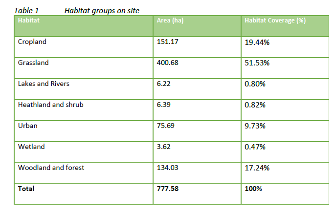
It starts by classifying different parts of the Area of Search into Habitat Groups

Shapley Heath Ecology and Biodiversity Habitat Groups

Shapley Heath Ecology and Biodiversity Habitat Groups

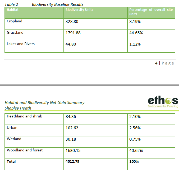
It then goes on to award “Biodiversity Units” to each group.

Shapley Heath Ecology and Biodiversity Units

Shapley Heath Ecology and Biodiversity Units

Biodiversity units are calculated using the Biodiversity Metric 2.0. The metric subjects the area of the habitats to a selection of multipliers which determine an areas biodiversity value. The multipliers are the condition of the habitat, its distinctiveness, its connectivity and its strategic significance. However, the report doesn’t explain how they assigned values to the various multipliers. They do caveat their results by making clear that the Biodiversity Metric 2.0 they used is a beta-test trial and the results maybe subject to change.

They go on to say that to enhance or maintain biodiversity, they need to retain high value areas and poorer areas “be targeted for removal”.

Shapley Heath Ecology and Biodiversity target areas for removal

Shapley Heath Ecology and Biodiversity target areas for removal

So, if you already live in the Area of Search, they’re going to target your house for removal.

Conclusions

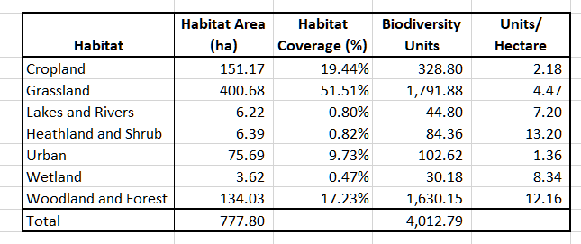
They conclude with a statement of the obvious. To increase biodiversity points, you have to increase biodiversity points.  However, they offer no advice on how to do that. By combining their tables we have been able to demonstrate that replacing any of the grassland or cropland with urban development, biodiversity will be reduced. This is because the average biodiversity units per hectare are lowest for urban areas.

Shapley Heath Ecology and Biodiversity Points per Hectare

Shapley Heath Ecology and Biodiversity Points per Hectare

This is contrary to the expectations set in the Project Overview:

Shapley Heath Project Overview BioDiversity Net Gain

Shapley Heath Project Overview BioDiversity Net Gain

The Shapley Heath survey last year even suggested that “green spaces within garden communities are also opportunities to enhance biodiversity and the natural environment”. It isn’t clear how they came to that conclusion on the basis of their own survey.

Ancient Woodland, Ancient and Veteran Trees

This is a 39-page report with an 8-page appendix again produced by EDP. Overall, this is a useful report detailing all of the areas of ancient woodland and a schedule of 37 veteran trees. The report points out that the NPPF says that development which might damage these areas be refused, unless there are exceptional circumstances. It recommends buffer zones around the veteran trees of around 5m from the edge of the canopy and 15m from the ancient woodland. Note the results of the survey expire two years after it was conducted. This means that the survey will be useless after December 2022.


Hart Massively Underestimates Infrastructure Funding Gap

Hart has recently launched a consultation about Community Infrastructure Levy or CIL. The consultation materials contain an updated Infrastructure Delivery Plan. Well, they call it a plan but as we shall see, that is something of an over-statement.

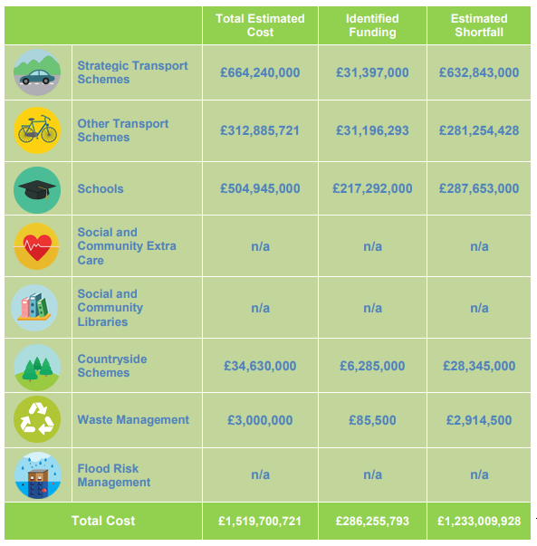
The “plan” indicates that there is an Infrastructure Funding Gap of £57.9m. This sounds a lot, but is actually an improvement on the £72.3m reported in 2017. We have summarised the funding gap shown in this paper from Hart in the image below:

Hart Infrastructure Plan 72% uncosted

Hart Infrastructure Plan 72% un-costed

The trouble is, the new figure is a massive under-estimate of the true picture. Why do we say this? As you can see from the image above, 116 of the 161 identified projects do not yet have confirmed costs. That’s right, they don’t even know the costs of nearly three quarters, or 72% of the projects they have identified. Of course, they don’t have any funding for those projects either, so the actual funding gap must be much wider than they claim.

There’s also a catalogue of errors and omissions throughout the Infrastructure Delivery Plan document:

  • Green Infrastructure Projects un-costed and unfunded
  • Healthcare projects un-costed and unfunded
  • S106 contributions over-allocated
  • Duplicated Projects

Green Infrastructure Projects Un-costed and Unfunded

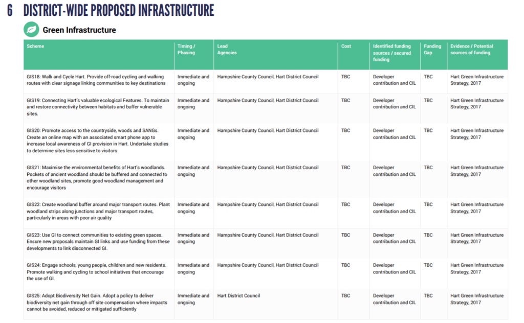
None of the district wide green infrastructure projects have been costed. They are supposed to be funded by unspecified developer contributions and CIL that is already going to close the £57.9m gap. This is despite all of the projects being classified as “Immediate and Ongoing” and Hart being named as a lead agency on most of them. This plan doesn’t seem to even include the much promoted “green grid”.

Hart Green Infrastructure Plans uncosted

Hart Green Infrastructure Plans un-costed and unfunded

Healthcare Projects Un-costed and Unfunded

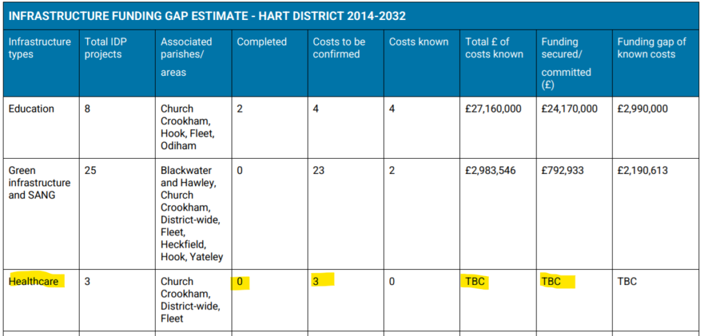
None of the healthcare projects has been costed. None have any funding allocated. The funding gap in unknown. To be fair to Hart, the funding should come from the NHS or central Government. However, this perhaps gives an indication why local GP surgeries are struggling.

Hart Healthcare projects uncosted and unfunded

Hart Healthcare projects un-costed and unfunded

Infrastructure Funding Gap – Over-allocated S106 contributions

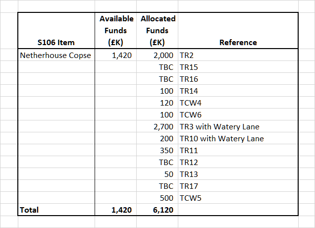
By way of example, we searched for all the places the £1.42m S106 contribution for Netherhouse Copse (now Hareshill) was mentioned. It turns out that it is mentioned as a source of funding for projects with costs totalling £6.12m. Some of the Watery Lane (now Albany Park) money is also earmarked for some of the projects. Some of the projects the £1.42m is supposed to fund, don’t even have costs. So, the funding is over-allocated by a factor of at least 4.

Hart Infrastructure Funding Over Allocated

Hart Infrastructure Funding Over Allocated

Duplicated Projects

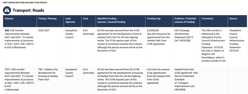
On some occasions, projects appear to have been duplicated. In this example, projects TR4 and TR21 appear to be cover the same improvements and have the same estimated costs.

Apparently duplicated Hart Infrastructure Projects

Apparently duplicated Hart Infrastructure Projects


Infrastructure Funding Gap Conclusions

It is clear that Hart has not got a grip on the Infrastructure Delivery Plan. It is simply not acceptable for 72% of the projects to remain un-costed at this stage. Remember the CCH leader promised “an infrastructure led Local Plan”. Yet, the plan they have shows a massive funding gap. They don’t have any idea about costs or funding sources for nearly three quarters of the promised projects. They have over-allocated large parts of the funding. It is clear the infrastructure plan is not going to be delivered.

If you still think Shapley Heath would deliver the promised infrastructure nirvana, I have an un-costed, unfunded and unbuilt bridge to sell you.


Hart Local Plan: No plans for infrastructure

Hart Local Plan Regulation 19 consultation: no proper plans for infrastructure

Hart Local Plan Regulation 19 consultation: no proper plans for infrastructure

This is the fifth part of our submission to the Hart Local Plan Regulation 19 consultation. This article explains how Hart haven’t properly planned for infrastructure. In addition, the plans they do have will starve the places that really need it of investment. Policy I1 needs to be changed and policy SS3 needs to be removed. The process for making a submission is as follows:

  1. Go to the Hart Local Plan Regulation 19 Consultation page of the Council website
  2. From the Hart website, download and complete Response Form Part A (Personal Details). A copy can be downloaded here.
  3. Also download and complete the Response Form Part B (Your Representations), a separate Part B is required for each representation you wish to make. A copy can be downloaded here.
  4. Make sure you include words of this form in each representation. Policy [X] is not sound because it is not [positively prepared, justified, effective or consistent with national policy] (delete as appropriate).
  5. Once you have filled in Part A and Part B, please email them to [email protected] or post them to Planning Policy Team, Hart District Council, Harlington Way, Fleet, Hampshire, GU51 4AE. 
Submissions have to be made before 4pm on 26 March 2018. If you are keen to get your submission completed, you can use the summary guide we have pulled together, or for the more adventurous, you can use our full submission. Please edit the text into your own words.
WHH Local Plan Reg 19 Guide
WHH Local Plan Reg 19 Entry

How the Hart Local Plan Regulation 19 consultation needs to be changed to deal with infrastructure

One leading councillor has gone on the record, calling for an ‘infrastructure led’ Local Plan. Yet, they have not allowed questions to be put to them about infrastructure, let alone answer them.

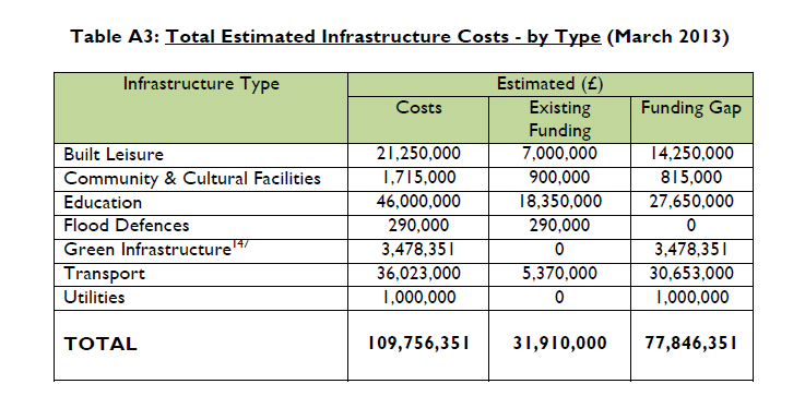
Back in October 2014, Hart Council produced an infrastructure delivery schedule that set out the current deficit, split by type and area.  This shows a deficit of £78m not including healthcare facilities. The breakdown is shown by type and area in the images below:

Hart Local Plan Regulation 19 consultation: Hart District Estimated Infrastructure costs by type March 2013.

Hart District Estimated Infrastructure costs by type March 2013.

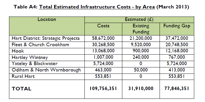
The breakdown of the costs by area showed the Fleet/Church Crookham and Hook areas had by far the largest deficits.

Hart Local Plan Regulation 19 consultation: Estimated Infrastructure costs by area March 2013

Hart District Estimated Infrastructure costs by area March 2013

Key quotes from the document include:

“It is therefore reasonable to conclude that it is unlikely that there will be sufficient future funds, from both capital programmes and developer contributions, within the plan period, to deliver all of the projects listed in the HCC Transport Statement”

“Although developer contributions will continue to play an important role in helping to bridge the funding gap, it is also clear that the funds raised through developer contributions will only contribute a modest proportion of the total identified funding gap”

 “The South West Main Line (SWML) outer trains, which serve Hart, has significant forecasted future peak crowding, with a capacity shortfall of over 6,100 passengers in the high-peak hour, even if every main line train is at maximum length”

It should be noted also that SWR has recently put forward proposals to reduce services at Winchfield and Hook, exacerbating the rail capacity problem. The Local Plan doesn’t even mention improvements to the rail network in infrastructure policies.

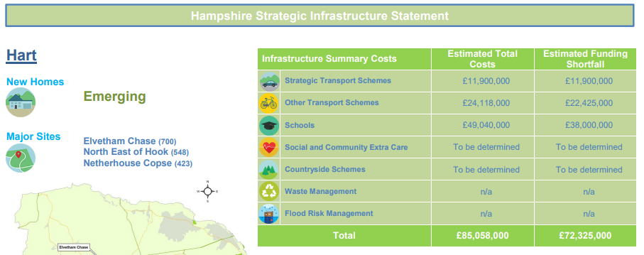
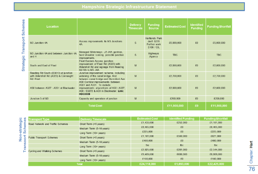
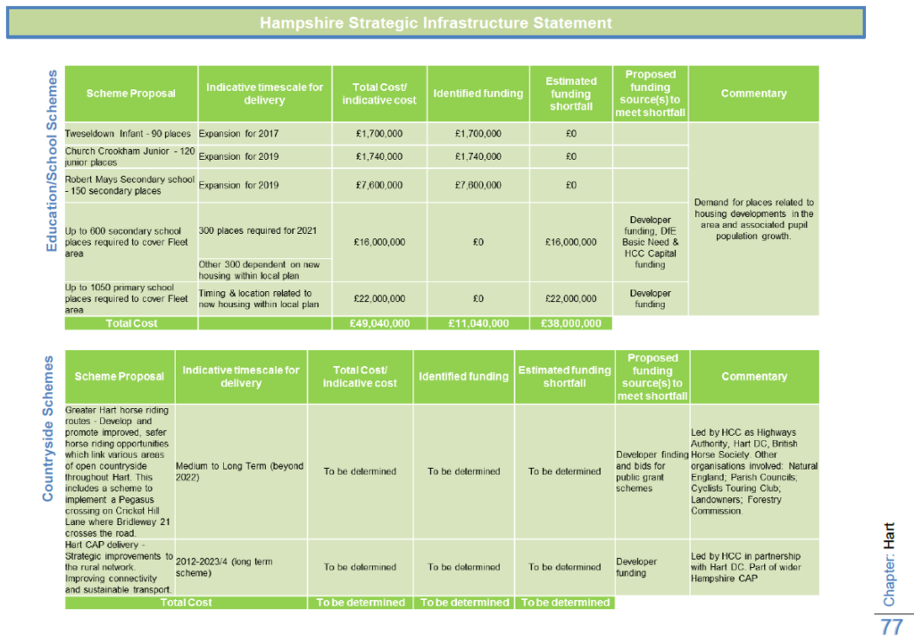
A more recent estimate from Hampshire County Council has estimated the infrastructure funding gap for Hart as £72m.

Hart Local Plan Regulation 19 consultation: Hart infrastructure funding gap £72m

Hart infrastructure funding gap £72m

Hart’s share of the gap is made up of:

  • Transport, £34m
  • Education: £38m.
  • Countryside: To be Determined.
  • Extra Care places: To be Determined.

No estimate has been made of the requirements or costs of additional healthcare provision.

The infrastructure policies in the Local Plan are insipid and fail to address the funding gap:

  • Policy I1: Infrastructure – weak policy simply requiring developers to deliver adequate infrastructure as part of their developments, when the studies above show that developer contributions won’t be adequate to bridge the gap
  • Policy I2: Green Infrastructure – feeble policy to supposedly protect green infrastructure. Yet they are proposing to build a new town that will destroy the best of our green infrastructure
  • Policy I3: Transport – inadequate policy simply to provide ‘maximum flexibility in the choice of travel modes’, nothing specific to improve road network or put pressure on SWR to improve rail
  • Policy I4: Open space, sport and recreation – policy to support development that improves sporting facilities, but no tangible plans for anything new
  • Policy I5: Community Facilities – a very vague policy to improve childcare facilities, healthcare, police stations, youth provision, libraries, community halls, local shops, meeting places, cultural buildings, public houses, places of worship, and public toilets. But crucially, no specific projects or proposals.

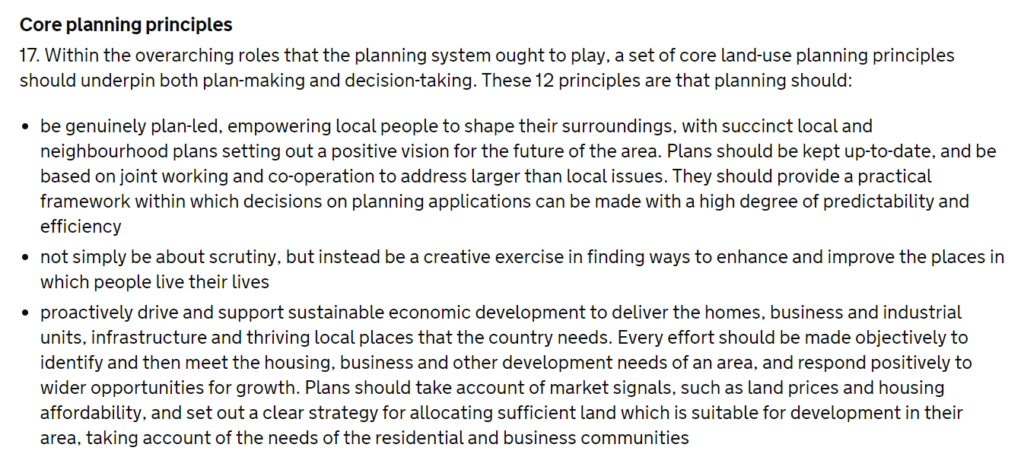
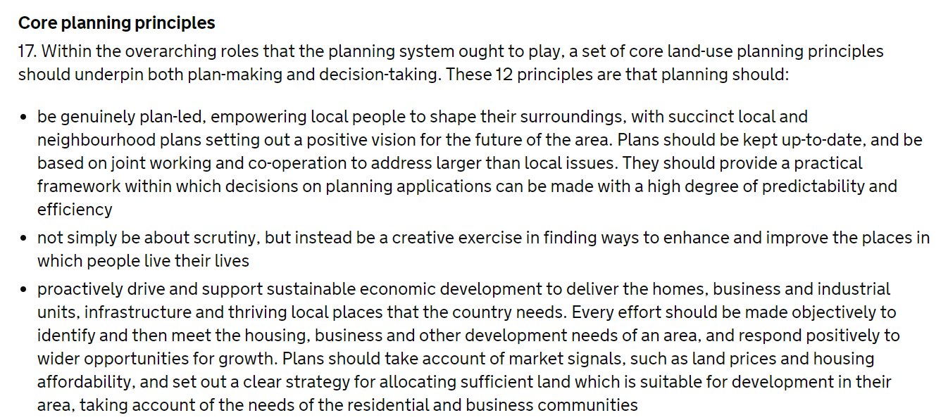
Yet, the National Planning Policy Framework (NPPF) is clear that infrastructure must be planned alongside new housing. Failure to adequately plan for infrastructure requirements and costs could lead to the Local Plan being found unsound. See references to paras 17 and 177 of the NPPF below.

plan to avoid infrastructure funding gap

NPPF Para 17: Avoid infrastructure funding gap

NPPF Para 17: Avoid infrastructure funding gap

It is clear from this post, that the proposals to build a new town will probably exacerbate the existing funding gap and not deliver any infrastructure in Fleet, Church Crookham and Hook, the very places where funding is most required.

Remedy: We therefore think the remedy to this issue should be that policy SS3 is removed in its entirety (with consequent changes to policy SS1 already outlined elsewhere). The infrastructure policies should be reworked to include as a minimum:

  • Acknowledgement of the existing £72m infrastructure funding gap
  • Quantification of the items missing from the Hampshire County Council assessment such as healthcare, extra-care housing for the elderly and green infrastructure
  • A set of prioritised, costed projects that are required to alleviate the worst of our infrastructure problems in Fleet/Church Crookham and Hook. This should include road improvements, particularly near Fleet station and the bridge over the railway near the end of Elvetham Heath Road. It should also include significant improvements to the cultural facilities, particularly in Fleet.
  • Plans to tackle Network Rail/SWR over rail capacity and services
  • Proposals for raising the necessary funds for delivering the required projects
  • Some external validation that the infrastructure plans in the draft Local Plan are ‘sound’ and will pass inspection

We believe that in preparation for the next review of the plan, a new policy should be created to regenerate our urban centres including attracting private capital so that we create a better place to live and address the existing infrastructure problems before even considering a new town that will only make matters worse.

Hart Local Plan: Remove Policy SS3 to build a new town

We have finally pulled together our submission to the Regulation 19 Hart Local Plan consultation. This, the first of a series of article explains some of the reasons why Policy SS3 to build a new town should be removed.

The process for making a submission is as follows:
  1. Go to the Hart Local Plan Consultation page of the Council website
  2. From the Hart website, download and complete Response Form Part A (Personal Details). A copy can be downloaded here.
  3. Also download and complete the Response Form Part B (Your Representations), a separate Part B is required for each representation you wish to make. A copy can be downloaded here
  4. Make sure you include words of this form in each representation. Policy [X] is not sound because it is not [positively prepared, justified, effective or consistent with national policy] (delete as appropriate).
  5. Once you have filled in Part A and Part B, please email them to [email protected] or post them to Planning Policy Team, Hart District Council, Harlington Way, Fleet, Hampshire, GU51 4AE. 
Submissions have to be made before 4pm on 26 March 2018. If you are keen to get your submission completed, you can use the summary guide we have pulled together, or for the more adventurous, you can use our full submission. Please edit the text into your own words.
WHH Local Plan Reg 19 Guide
WHH Local Plan Reg 19 Entry

Why should Policy SS3 for a new town be removed from the Hart Local Plan?

The most egregious part of the draft Local Plan is the proposal to include an unnecessary new town. This should be removed for the following reasons:

  • The new town is not required, even with the inflated housing numbers in Policy SS1
  • The proposal is unsustainable and undeliverable
  • The supposed sweetener of a secondary school is unnecessary and won’t be placed in a viable location
  • Will lead to coalescence with surrounding settlements
  • Breaks a number of the council’s own objectives elsewhere in the plan
  • It will hinder the much needed regeneration of our urban centres, in particular Fleet

The new town is not required

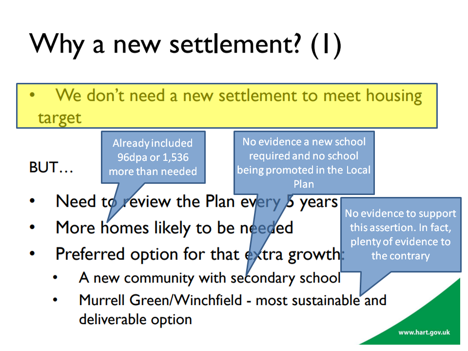
The housing numbers in the draft Local Plan are too high. Even if one assumes the housing numbers are correct, the council itself admits that the new town is not required.

Hart Local Plan Regulation 19: Hart say we don't need a new town

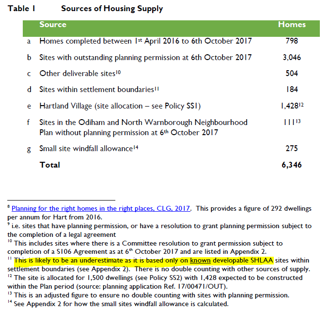
Not only that, the council themselves admit that the housing supply is under-estimated.

Hart Local Plan Regulation 19: Understated housing supply

And even this under-estimate does not include housing supply identified in the Winchfield and Hartley Wintney Neighbourhood plans.

The combination of the over-inflated housing demand numbers and the under-stated housing supply numbers mean that the new town simply is not required.

The new town proposal is unsustainable

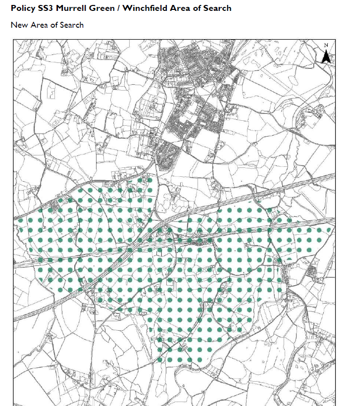
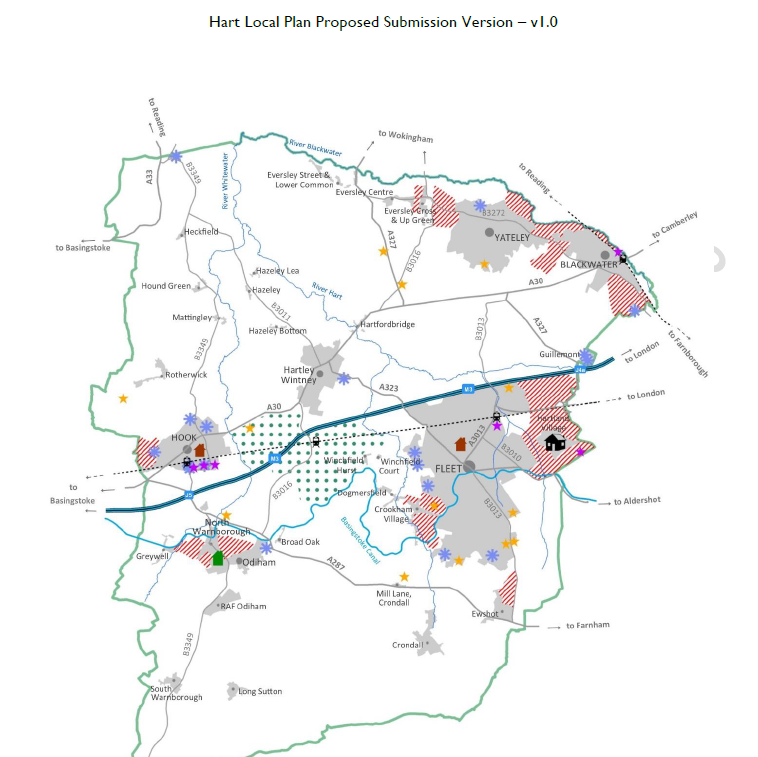
The area of search identified in the Local Plan contains a very wide area, consisting of the areas known as Murrell Green and Winchfield.

Hart Local Plan Regulation 19: Policy SS3 Murrell Green and Winchfield Area of search for Hartley WInchook new settlement

We don’t need Hartley Winchook new town so why is it in the Local Plan?

The attempts at sustainability appraisals of the Murrell Green and Winchfield sites have been poor, but nevertheless have demonstrated some very significant weaknesses that cannot be overcome.

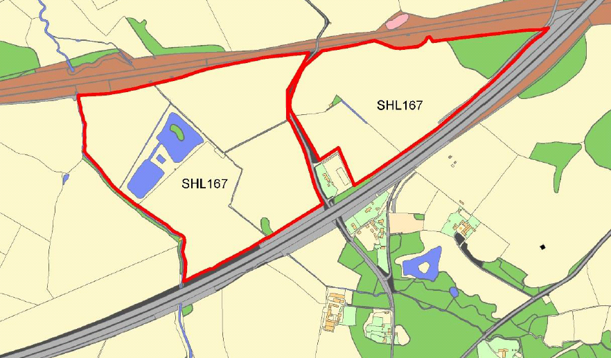
SHL167 SHLAA Map - Beggars Corner, Winchfield, Hart District, Hampshire

SHL167 SHLAA Map – Beggars Corner, Winchfield, Hart District, Hampshire

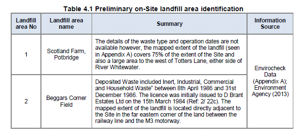
Let’s deal with Murrell Green first. Part of the site, known as Beggars Corner was the subject of a planning application for a Solar Farm. This was refused on the grounds that it would spoil the views from Odiham.  It is difficult to see how a 1,800 unit development would be any less intrusive than a solar farm. Moreover, that planning application identified that part of the Beggars Corner location is former landfill and some of it has unknown contents. This does not appear to be a suitable location on which to build new houses, or indeed form part of a SANG.

SHL 167 Landfill details Beggars Corner

SHL 167 Landfill details Beggars Corner, Winchfield, Hart District, Hampshire

The sustainability appraisal conveniently did not cover this part of the proposed Murrell Green development.

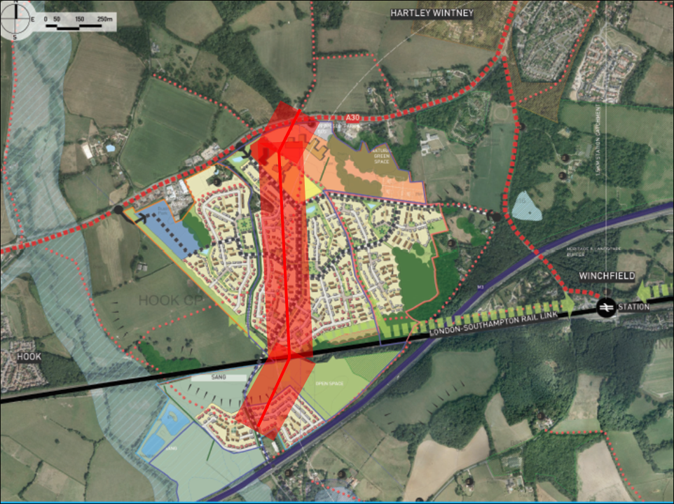
Moreover, the SA did not manage to discover that there is a Major Accident Hazard Pipeline crossing the site.  Not only that, the developer’s proposal included a secondary school sited right on top of the pipeline. After examination of the HSE rules regarding such installations, I conclude that neither houses nor schools will be able to be built within up to 100m of that pipeline. I also understand that roads should not cross such pipelines either. See analysis here.

Murrell Green high pressure gas main

Murrell Green development with high pressure gas pipeline

When one adds in other constraints such as SINCs, proximity of a high voltage power line, the railway and the M3, it appears as though the Murrell Green part of the area of search is not suitable for large scale development.

Turning to the Winchfield part of the area of search, it should be noted that the Winchfield sustainability assessment had to be extracted from HDC by FOI request. It can be found here.

The first point to note is that much of land in the Winchfield area of search is not in fact for sale. This comprises the central swathe known as Talbothay’s Farm plus other areas. Immediately, this leads to the conclusion that it won’t be possible to plan for a coherent settlement if the central part is not available.

In addition, the main areas considered to be constraints in the SA report were:

  • Historic Environment
  • Bio-diversity
  • Landscape
  • Water Quality
  • Flood risk

More detail on this can be found here. Other spurious claims were made in the SA, such as the claim that building a “renewable and low-carbon energy generation and transfer” plant will diversify energy supply. What they mean is building a wood-burning power station utilising locally sourced timber (p74). Such a plant would be extremely undesirable since burning wood produces more CO2 than burning coal, and none of the proposed master plans include such space for such a plant. Plus, of course, I don’t think many people would support chopping down Bramshill forest to fuel such a plant. This claim was used to indicate that Winchfield was somehow more sustainable than other potential locations.

They also claim that building 3,000 new houses, with associated traffic will somehow “reduce the
emissions of greenhouse gases and manage the impacts of climate change”. Again, complete and utter nonsense.

They also say there was some evidence of wet ground at the far east of SHL183, but “no other obvious evidence of current or past flooding”.

Winchfield Strategic Assessment - Flood Risk 1

This is of course complete nonsense. The detailed assessment also says there’s only a one in 30 year chance of surface water flooding. The area of Taplins Farm Lane near the railway bridge flooded three times in 2016 alone. Evidence documenting the flood events can be found here (4 Jan) , here (7 Jan)here (9 March on Station Road) and here (28 March due to #StormKatie). I also understand that a similar area has flooded again in January 2018. These are obviously more than one in 30 year events.

The area east of Winchfield fared less well than Murrell Green in the sustainability assessment even with the grossly understated the flood risk. And of course there were other issues with Historic Environment, Bio-diversity, Landscape and Water Quality. It is difficult to see how this could deliver a significant number of houses.

The area west of Winchfield was ruled out of the sustainability assessment, because it is a more peripheral location relative to the train station, does not offer a central focus and is in close proximity to Odiham SSSI. It therefore offers little prospect of significant housing development.

It is clear that there are very considerable constraints even before considering the infrastructure problems.

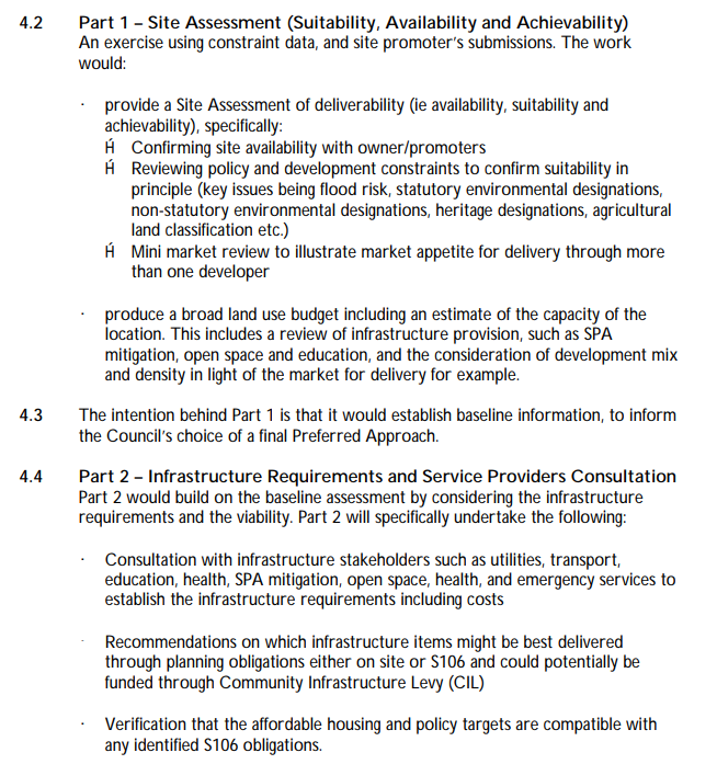
Hart has not put together proper estimates of the costs of infrastructure; despite saying it would do so.

Hart Testing Commitment January 2015

We have made several estimates that can be found here, here and here. Essentially, if a new motorway junction is required, the costs will be in excess of £300m. If the new junction is not required, the costs will be at least £200m. A rough schedule of requirements includes:

  • Secondary school and three primary schools
  • New sewage works
  • Power station (as per SA)
  • Improved drainage
  • Re-routing or burying of electricity power lines
  • Railway station upgrade to extend platforms and car park (or relocate)
  • The bridges that carry the railway over Station Road, Taplins Farm Lane and Pale Lane will all need to be upgraded in some way
  • New big roundabouts at either end of the B3016
  • New smaller roundabouts from B3016 and A30 to the new town, new roundabout to join Pale Lane and the A323, new roundabout on A287/Crondall Road and at Pilcot Road/Hitches Lane
  • New or widened roads at Bagwell Lane, Taplins Farm Lane/Church Lane, Station Road, Pale Lane and Chatter Alley/Pilcot Road. Plus many ancient hedgerows will have to be relocated.
  • Potentially widening the A30 around Phoenix Green on the approach to artHHartley Wintney
  • New healthcare facilities
  • New sports and community facilities

If this is a 5,000 dwelling new town, with 40% ‘affordable’, the remaining market houses might be expected to generate £15-20K per unit of S106/CIL. This would amount to around £45-60m. This is well short of the funding requirement and therefore might be expected to make the existing infrastructure funding gap worse.

Taken together, it is difficult to see how such a new town could be either sustainable or viable. Indeed, it is notable that in the three years of this saga, with many Hart Council members being supportive and apparently developers becoming anxious, no planning application has been made. Perhaps that’s because the developers also realise this is a pipedream.

Secondary school unnecessary and not in a suitable location

A number of councillors have made a fuss about a new settlement bringing a new secondary school. The trouble with this is that they have yet to provide a shred of evidence that a new secondary school is in fact required.

Back in 2015, Hampshire’s forecast went as far as 2018 and they were predicting a surplus of places up to 2018. They also forecast a falling birth rate and a significant number of existing pupils attending Hart schools from outside the district.

In 2017, HCC published a new school place plan that showed an overall surplus of places in both secondary and primary schools up to 2021.

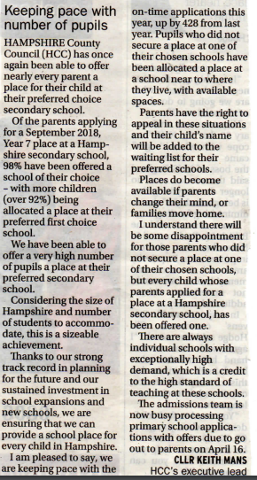
A recent letter from a Hampshire Councillor shows that 98% of Hampshire secondary pupils have been allocated a place at a school of their choice for the next academic year.

Hampshire schools keep up with demand

So, having established that a new school is probably not required, we must now address the proposals that have been put forward over the past three years for the sites of new secondary schools.

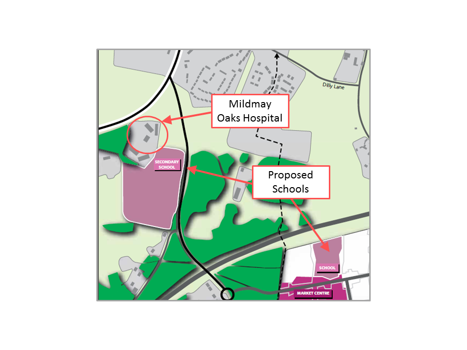
First, we had Barratts in 2014 putting up a proposal to place a new school right next door to an institution housing sex offenders.

Mildmay Oaks Hospital next door to proposed school

Proposed school next door to Mildmay Oaks Hospital that held escaped child sex offender

Then we had the proposal, described above to build a secondary school right on top of the high-pressure gas main running through the Murrell Green site.

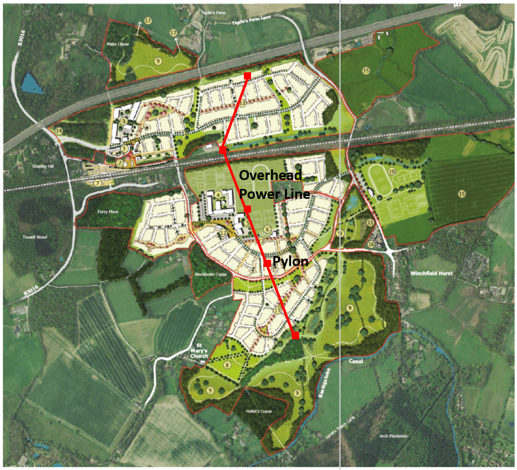
More recently we have had another proposal from promoters of Winchfield which placed the secondary school directly under the high-voltage power lines.

Winchfield Garden Community Master Plan with pylons and powerline

Winchfield Garden Community Master Plan with pylons and powerline

If after three years of trying, they cannot find a suitable location for a secondary school, one does have to come to the conclusion that they never will.

In conclusion, it is apparent that we don’t need a secondary school, and none of the developers involved have managed to find a suitable location.

Coalescence

The area of search is very wide. It borders Hook to the west, Hartley Wintney/Phoenix Green to the north east and comes very close to the Edenbrook development and the proposed Pale Lane development to the east. The bulk of the proposal also comes very close to Dogmersfield.

In other areas of the Local Plan, the council have been quite assiduous in defining strategic gaps. They have produced no such gaps around the new area of search, nor to the east of Hook or anywhere around Hartley Wintney. Nor are any gaps proposed to the north west of Fleet.

Hartley Winchook leads to no strategic gaps around Hartley Wintney nor to the east of Hook

If they are allowed to go ahead with this area of search, unconstrained by strategic gaps, there is a strong risk that they will come up with proposals that lead to coalescence of our proud villages.

Breaks the Objectives elsewhere in the Hart Local Plan

Elsewhere in the Local Plan, Hart have come up with a number of objectives. These are reproduced below with my comments in bold on how these proposals break those objectives.

  1. To support the vitality and viability of the District’s town and village centres to serve the needs of residents. Adding a new settlement will draw retail traffic away from our existing urban centres, most notably Fleet, and lead to even faster degeneration of Fleet as a retail destination. This can hardly be described as supporting vitality and viability.
  2. To conserve and enhance the distinctive built and historic environment in the District including the protection of heritage assets and their settings. The proposed area of search includes a Norman church dating back to the Domesday Book and several SSSI’s including at Odiham and Basingstoke Canal. There are numerous other distinctive and historic buildings. Building a new settlement right next door to these valuable assets with neither conserve nor enhance the environment.
  3. To protect and enhance the District’s natural environment, landscape character, water environment and biodiversity, including ensuring appropriate mitigation is in place for new development to avoid adverse impacts on the Thames Basin Heaths Special Protection Area (TBHSPA).Building a new settlement in one of the most attractive parts of the district, containing many woodlands and hedgerows supporting much wildlife such as deer and kingfishers, used by many for leisure and recreation will actively damage the landscape and biodiversity.
  4. To provide measures for adapting to the impacts of climate change and minimising the contribution of new development to the causes of climate change, including reducing the risk of flooding by directing development away from areas at risk of flooding, and using opportunities offered by new development to reduce the causes and impacts of flooding from all sources. We have already established that the SA grossly under-stated the flood risk in the area known as Winchfield East, yet they are proposing to build on this area, directly against their stated objective.
  5. To promote healthy and sustainable local communities through protecting and enhancing community, sport, health, cultural, recreation and leisure facilities, and through the delivery of a multi-functional green infrastructure network across the District. We already have a multi-functional green infrastructure network in Winchfield used for recreation and leisure. Building on it will destroy it, again directly contravening their own objective.
  6. To maintain the separate character and identity of settlements by avoiding development that would result in their physical or visual coalescence. Again, we established the risk of coalescence earlier. This proposal, if implemented would effectively create a single urban conurbation from Hartland Park in the east, across Fleet and Hartley Wintney to Hook in the west. This is an appalling prospect, again directly breaking their own objective.

Remedy:  I would propose that Policy SS3 is removed entirely from the Hart Local Plan, and consequent amendments are made to SS1.

Time to oppose silly Hartley Winchook new town in Local Plan

Policy SS3 Murrell Green and Winchfield Area of search for Hartley WInchook new settlement

We don’t need Hartley Winchook new town so why is it in the Local Plan?

Hart District Council has begun the Regulation 19 consultation on the Local Plan. This is the final version before submission to the Inspector later this year. Unsurprisingly, this still contains Policy SS3, with proposals for the entirely unnecessary Hartley Winchook new town.

The consultation run from 9 February 2018 to 4pm on 26 March 2018. The whole suite of documents can be found here.

We will, of course, oppose the new town elements of the Local Plan. However, we have to take great care in opposing the plan, because the worst outcome would be that the whole plan is failed by the Inspector.

Hart says that representations about the Local Plan should relate to legal compliance, duty to cooperate and tests of soundness. Helpfully, the council has provided a guidance note on how to respond.

We beleive there are grounds to challenge the plan on the grounds of soundness. Overall our objective should be to get Policy SS3 removed, together with the necessary grammar changes to Policy SS1 to ensure consistency.

How will the Inspector assess the Local Plan

We understand the Inspector is going to look at seven key areas:

1. Duty to co-operate / legal compliance
2. Spatial strategy
3. Housing numbers
4. New settlement area of search
5. Town centre regeneration
6. Infrastructure
7. Development management policies

We believe the spatial strategy is flawed, because it includes provision for the new town, which is enitrely unnecessary to meet the still inflated housing numbers.

The housing numbers themselves are based on the new Government methodology. However, they have included an arbitrary 25% uplift to the requirement, which we believe is too high.

The new settlement area of search is very wide and covers areas that have already not passed testing:

  • The area west of Winchfield was ruled out of the sustainability assessment, because it is a more peripheral location relative to the train station, does not offer a central focus and is in close proximity to Odiham SSSI.
  • The area east of Winchfield fared less well that Murrell Green and of course the sustainability assessment grossly understated the flood risk. And of course there were other issues with Historic Environment, Bio-diversity, Landscape and Water Quality.
  • The sustainability appraisal famously did not take account of the high-pressure gas main traversing the site.

Moreover, it is highly likely that the costs to deliver the required infrastructure will far exceed any realistic assessment of developer contributions.

Hart acknowledge that Fleet will face a challenge “to secure investment so that it can compete with the comparable towns in neighbouring districts”. Yet, the local plan contains no plans to regenerate our main town centre.

The infrastructure plan is paper thin, and they offer no solutions on how to close the £73m infrastructure funding deficit and no plans in particular to improve healthcare in the district.

The development plan policies contain a number of strategic gaps around the district, but leave Hartley Wintney totally exposed with no strategic gaps planned.


Hartley Winchook leads to no strategic gaps around Hartley Wintney nor to the east of Hook

We will pull together a more detailed response in the coming weeks.

New Local Plan fails to address infrastructure funding gap

Hart District Council Failed to address infrastructure funding gap

Hart Local Plan Fails to address infrastructure funding gap

The new draft Local Plan fails to address the infrastructure funding gap facing Hart. At the very least, this fails the residents of Hart, but sadly, may render the plan unsound at inspection. We therefore believe significant extra work needs to be done before this version of the Local Plan is put to consultation later this month.

Why is infrastructure so important to the Local Plan?

The National Planning Policy Framework (NPPF) is clear that infrastructure must be planned alongside new housing. Failure to adequately plan for infrastructure requirements and costs could lead to the Local Plan being found unsound at inspection. See references to paras 17 and 177 of the NPPF below.

plan to avoid infrastructure funding gap

NPPF Para 17: Avoid infrastructure funding gap NPPF Para 17: Avoid infrastructure funding gap

Recently, the leader of Community Campaign Completely Concrete Hart, James Radley went on the record in Fleet News and Mail saying he would deliver an ‘infrastructure led’ Local Plan.

We tried to ask questions at Hart Council about the £72m infrastructure funding gap, but our questions were not allowed to be even asked, let alone answered.

Hart infrastructure funding gap £72m

Hart infrastructure funding gap £72m

Now the draft Local Plan has emerged, and it is clear why they were so reluctant to answer questions.

What are the infrastructure proposals in the Local Plan?

That is very good question, to which there is only an inadequate answer. As far as we can tell, there are five fairly insipid ‘policies’ about infrastructure, and that is it:

  • Policy I1: Infrastructure – weak policy simply requiring developers to deliver adequate infrastructure as part of their developments
  • Policy I2: Green Infrastructure – feeble policy to supposedly protect green infrastructure
  • Policy I3: Transport – inadequate policy simply to provide ‘maximum flexibility in the choice of travel modes’, nothing specific to improve road network
  • Policy I4: Open space, sport and recreation – policy to support development that improves sporting facilities, but no tangible plans for anything new
  • Policy I5: Community Facilities – a very vague policy to improve childcare facilities, healthcare, police stations, youth provision, libraries, community halls, local shops, meeting places, cultural buildings, public houses, places of worship, and public toilets. But crucially, no specific projects or proposals.

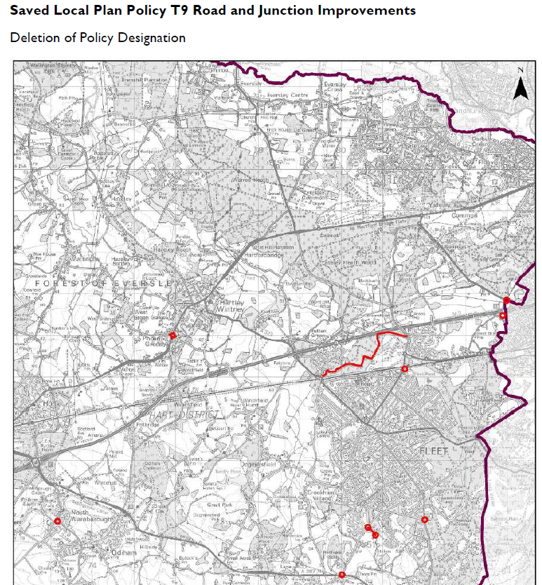
However, it gets worse. In the details of the infrastructure proposals, several road and junction improvement schemes have been dropped. Examples include the junction near Fleet railway station;  the junction between the A30 and Thackams Lane at Phoenix Green and the junction between the A287 and Redfields Lane.

Deletion of road and junction improvement policies to avoid infrastructure funding gap

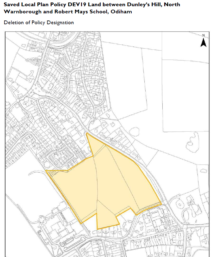
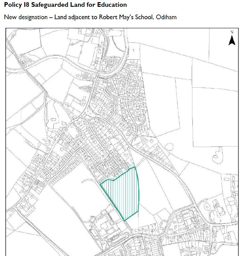
Moreover, the amount of land set aside for school expansion has been reduced. Here is the before and after map for Robert Mays.

Land for Robert Mays Expansion (Before)

Land for Robert Mays Expansion (Before)

Land for Robert Mays Expansion (After)

Land for Robert Mays Expansion (After)

This simply isn’t good enough.

What infrastructure proposals should we expect?

We would expect as a minimum:

  • Acknowledgement of the existing £72m infrastructure funding gap
  • Quantification of the items missing from the Hampshire County Council assessment such as healthcare, extra-care housing for the elderly and green infrastructure
  • A set of prioritised, costed projects that are required to alleviate the worst of our infrastructure problems. This should include road improvements, particularly near Fleet station and the bridge over the railway near the end of Elvetham Heath Road. It should also include significant improvements to the cultural facilities, particularly in Fleet.
  • Proposals for raising the necessary funds for delivering the required projects
  • Some external validation that the infrastructure plans in the draft Local Plan are ‘sound’ and will pass inspection

Perhaps if the councillors spent less time planning for a new town we don’t need, they would then be able to focus on the real needs of the district.

Hart Council refuses to answer infrastructure questions

Last week, we tabled six infrastructure questions to be answered at tonight’s council meeting. We found out last night that five of them won’t be answered for dubious reasons.  We think this behaviour form the council is dangerously authoritarian. Our questions (in bold), Hart’s reasoning, and our response (in red) are shown below.

In essence, it seems that the CCH/Lib Dem administration does not want to face facts about school and infrastructure provision. This is frankly pathetic, and does not bode well for the quality of the next version of the Local Plan that is due to be published before Christmas, in preparation for a Cabinet meeting in early January.

Infrastructure Questions – Schools

Q1: Hampshire County Council have recently published a school places plan that shows a surplus of secondary school places up to 2021. There is now extra space for expanding Calthorpe Park. Would a new secondary school be required if the Local Plan was based on:

  1. The 10,185 units in the draft Local Plan?
  2. The 8,022 units in the SHMA?
  3. The 6,132 units (or ~6,500 if Hart needs to build some extra for Surrey Heath) implied by the recent Government consultation on the approach to calculating housing need?

Notwithstanding the fact that the question is badly framed because it seeks to compare a short term School Places Plan with a much longer Local Plan which would run to 2032 (therefore there is no possibility of a genuine comparison), Hampshire County Council has a statutory duty to ensure a sufficiency of school places for Hampshire children. Therefore the hypothetical question set out in the question about the need for a secondary school should be put to Hampshire County Council as Hart District Council is not promoting a new secondary school other than working with Hampshire County Council to secure the long term availability of land for a possible future secondary school.

We are therefore rejecting the question as it relates to a matter for Hampshire County Council and also the answer will not inform any current decisions or scenarios that are being considered by Hart District Council.

The question will not be put to Council on Thursday.

For background information Hampshire County Council made comments in respect of 10,185 units. These can be viewed on the Council’s web site at: https://www.hart.gov.uk/sites/default/files/4_The_Council/Policies_and_published_documents/Planning_policy/Local_Plan/EM143%20-%20Hampshire%20County%20Council.pdf

Given the Government has published new guidance on how to calculate housing need, we think it is perfectly reasonable to ask questions about how that will impact school place planning. We wish that HCC had done pupil forecasting beyond 2021, but they haven’t. We were not comparing HCC’s time horizon with the Local Plan period, merely noting that up to 2021, no new secondary school is required. The purpose of the question was to find out if this would remain the case up to 2032 under a range of housing target scenarios. We think this analysis is crucial to creating a sound Local Plan. 

Q2: The school places plan also shows continuing pressure on Fleet schools. Given that there is significant development proposed at Sun Park and Hartland Village, have you considered siting a new secondary school, if required, at Hartland Village or using part of the Bramshot Farm SANG?

Apparently, this question will be answered tomorrow.

Q3: HCC has also published an Infrastructure Statement showing the cost of a 150-pupil expansion of Robert Mays to be £7.6m. Scaling this up, a 9-form entry secondary school at Murrell Green or Winchfield would cost ~£68m. The expected developer funding from an 1,800 unit development with 40% affordable would be around £16m. How do you propose to fund the remaining budget for the school plus necessary the road improvements and community infrastructure?

Hampshire County Council has a statutory duty to ensure a sufficiency of school places for Hampshire children. The scenario presented in Q3 about education costs is based upon speculation that does not reflect true costings (benchmarking costs as published on Hampshire County Council’s web site at http://documents.hants.gov.uk/education/NationalSchoolDeliveryCostBenchmarking-PrimarySecondarySENSc.pdf).  

(It will confirm that the scenario of £68m is quite unrealistic)

We have checked this source, and they are quite right, using the median estimate per pupil, a 9-form entry, 1,350 pupil school would cost around £27.3m. However, this is somewhat below Hart’s/HCC’s own assessment in July 2015, of £56-60m. So, we don’t think our £68m estimate is out of the ballpark, given it is based on more recent budget numbers for a school extension. In any event, this is not a reason to refuse to answer the question.

In any event, the question is badly framed. It is not a proper question to put to Council as it is more of a hypothetical and speculative debating point. It starts with a false premise about secondary school cost (£68m for a secondary school that is not being promoted through the emerging Local Plan) and then goes on to make uninformed speculative statements on developer funding and cost without any supporting evidence base. The suggested conclusion is not logical either. The published facts confirm that for Murrell Green for example, the development will, in addition to its own infrastructure costs, deliver 40% affordable homes, £34.5m in S106 contributions, and still leave the developer a healthy and viable surplus.

A new school was certainly being promoted in the draft Local Plan, so we feel the question is entirely reasonable. The estimate of £34.5m S106 contributions for Murrell Green is entirely new to us. We based our calculation as follows. 1,800 units in total, 40% affordable leaves 1,080 units available to make contributions, of around £14,800 per unit. At an average price of £500,000 this would mean arond 3% of revenues, or around 20% of estimated net margin of 15% of selling price. Hart’s estimate of £34.5m assumes £32,000 per unit that sounds on the high side to us.

The next version of the Local Plan at formal Regulation 19 Publication stage will show how much housing we are planning for and where it is going. The accompanying infrastructure plan to support the development proposed will be published alongside it.

The Chairman is, therefore, rejecting the question for the above reasons as we consider that the preparation of an answer to such hypothetical and speculative scenarios would require a disproportionate amount of time, money, and effort in circumstances where the work required to answer the question would not inform any decisions to be made by the Council.

We don’t think it is at all hypothetical to ask about how our infrastructure will be funded. Indeed, James Radley has recently gone on the record calling for an “infrastructure led” Local Plan, which makes our questioning even more relevant.

The question will not be put to Council on Thursday.

Infrastructure Questions – Overall Funding

Q4: The same Infrastructure Statement showed an overall funding gap of £72m for Hart. The figures don’t include healthcare, extra-care places for the elderly nor countryside services. How do you propose to quantify the un-costed items and to close the funding gap?

The question again is badly framed and fundamentally mis-quotes the purpose of Hampshire’s Infrastructure Statement.  It also confuses matters that are not infrastructure funding or relevant to funding from new development. 

We have not misquoted Hampshire’s document. OUr report about it, and relevant images from the document can be found here. All of the elements in our question are in Hampshire’s statement. It is entirely reasonable to ask how the funding gap will be closed, whether through development or other means.

For the record, the HCC Infrastructure Statement set out the requirements identified to support growth, but it does not attempt to set priorities with regard to funding. The Statement also specifically recognises that local authorities cannot require developers to fund existing deficiencies in infrastructure provision.

We never said it did.

In this regard, there is no expectation that development in Hart or any other District should seek to meet the overall funding gap as identified in the Infrastructure Statement (because much of the infrastructure deficit is historic) but infrastructure funding will be required to mitigate the adverse effects arising from the development itself.  

We shall have to agree to disagree. When the Deputy Leader goes on the record calling for an ‘infrastructure led’ Local Plan, then it does set an expectation that our creaking infrastructure will be fixed. The reason why we have an historic funding deficit is continued mismanagement and inability to focus on getting infrastructure right. It seems by refusing to answer questions about it, the council is going to continue in the same vein. Continuing to do the same thing whilst expecting a different result is the definition of stupidity.

The next version of the Local Plan at formal Regulation 19 Publication stage will show how much housing we are planning for and where it is going. The accompanying infrastructure plan to support that development will be published alongside it.

The Chairman is, therefore, rejecting the question for the above reasons as we consider that the preparation of an answer to such hypothetical and speculative scenarios would require a disproportionate amount of time, money, and effort in circumstances where the work required to answer the question will would not inform any decisions to be made by the Council.

The question will not be put to Council on Thursday.

Infrastructure Questions – Alternative Scenarios

Q5: What is the expected incremental infrastructure funding requirement and contribution from developers if you were to construct the Local Plan based on:

  1. The 10,185 units in the draft Local Plan?
  2. The 8,022 units in the SHMA?
  3. The 6,132 units (or ~6,500 if Hart needs to build some extra for Surrey Heath) implied by the recent Government consultation on the approach to calculating housing need?

This question is based upon retrospective or hypothetical scenarios that are not being advanced by the Council.  These again are debating points and not a proper question to be put to Council.  In any event, the next version of the Local Plan at formal Regulation 19 Publication stage will show how much housing we are planning for and where it is going. The accompanying infrastructure plan to support development in the Local Plan will be published alongside it.

These are not hypothetical scenarios. The draft Local Plan called for 10,185 new houses. THe SHMA came up with 8,022. The consequence of the new Government consultation on housing need is 6,132 units. It is perfectly reasonable to expect the council to do some strategic scenario planning to calculate the different costs and contributions to infrastructure that might be expected under each scenario and make decisions accordingly. 

The Chairman is therefore, rejecting the question for the above reasons as we consider that the preparation of an answer to such hypothetical and speculative scenarios would require a disproportionate amount of time, money, and effort in circumstances where the work required to answer the question will would not inform any decisions to be made by the Council.

We asked the question because we thought they would have already done this work. It is fundamental to the decision-making process.

The question will not be put to Council on Thursday.

Pathetic.

Q6: Which of the above options would result in the lowest infrastructure funding gap?

This question is based upon hypothetical scenarios that are not being advanced by the Council.  These again are debating points and not a proper question to be put to Council.  In any event, the next version of the Local Plan at formal Regulation 19 Publication stage will show how much housing we are planning for and where it is going. The accompanying infrastructure plan to support the Local Plan proposals will be published alongside it.

No, it is asking for a conclusion, based on the previous question. I think we all know that we will end up with a lower infrastructure funding gap if we go with a lower housing number. The council has a duty to at the very least consider this and make decisions based on sound data and information. And we as residents should expect no less from our elected representatives.

The Chairman is, therefore, rejecting the question for the above reasons as we consider that the preparation of an answer to such hypothetical and speculative scenarios would require a disproportionate amount of time, money, and effort in circumstances where the work required to answer the question will would not inform any decisions to be made by the Council.

The question will not be put to Council on Thursday.


Goalposts changed in SWR timetable consultation

South West Trains SWR timetable consultation

South West Trains SWR timetable consultation comparison

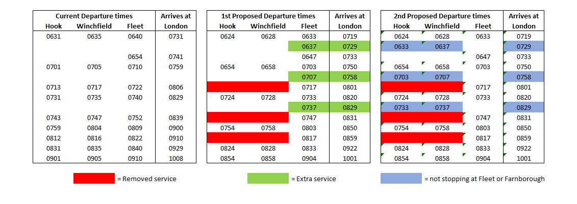
The goalposts have been changed in the South West Railway SWR timetable consultation. As you may know already, SWR launched a consultation on the train timetable in late September. However, in response to negative feedback they have revised their proposals.

These new proposals are still unacceptable. Sorry to say this, but even if you have already responded to the first proposals, please respond to these new proposals. Please use the download below to respond to consultation by 22 December 2017. Feedback can be sent to: [email protected]

SWR timetable consultation

Please also sign Ranil’s petition which can be found here.

Impact of South West Railway SWR timetable consultation

The current line to London is already running beyond capacity, and these changes represent a reduction in service at peak hours which cannot be a good idea.

In summary the changes proposed are:

  • Retains the same number of services from Hook and Winchfield to London, however, many of these services now no longer stop at Fleet and Farnborough
  • Keeps the same number of Fleet to London services as now
  • The new proposals result in slightly faster services to London

The impact of these changes will be:

  • School children and students attending Farnborough Sixth form, Salesian and Farnborough Hill will now have far fewer services to choose from to get from Hook/Winchfield to Farnborough.
  • This is likely to lead to both over-crowded trains and increased car journeys, leading to more pollution and congestion
  • No effective increase in capacity from Fleet, Winchfield and Hook to London, even though services are already over-crowded.

Alternative approach to SWR timetable consultation

Thousands of houses have either already been given permission or are proposed in Hart’s Local Plan. These include around 500 dwellings at Sun Park, 1,500 Hartland Village, and 420+ at Grove Farm all near to Fleet station. Moreover, 550 houses are currently being built in NE Hook and 1,800 dwellings are proposed at Murrell Green, both close to both Hook and Winchfield stations. Many hundreds more dwellings are being considered on brownfield sites in Hook. It does seem rather odd that SWR are not proposing to dramatically increase services just at the time when demand is going to increase. I would suggest the following alternative plan:

  • Ensure that many more of the Hook/Winchfield services stop at Fleet/Farnborough to help our kids get to school
  • Increase services from Fleet to London
  • Increase capacity by running more 12-car trains on the whole line at peak times
  • Reduce the number of first class carriages on 8 and 12-car trains to further increase passenger capacity


Hart Corporate Plan Consultation – please respond

Hart Corporate Plan: Liberal Democrats David Dave Neighbour in the pocket of Community Campaign Hart James Radley

Hart Corporate Plan: Liberal Democrats in the pocket of Community Campaign Hart

A consultation has been launched on the latest iteration of the Hart Corporate Plan. Whilst this contains some welcome initiatives, there are other developments that are of significant concern.

We rask that you respond to the consultation that can be found here. The deadline is 4pm on 31st October 2017. We suggest you make the following comments:

  1. Communities. Restore the plan to create a Hart-controlled trading company to deliver much needed social housing to the district.
  2. Communities. Drop the idea of delivering more houses than identified in the SHMA, and follow the new Government housing target of 6,132 instead.
  3. Communities: Focus infrastructure spending on the areas most in need: roads, education and healthcare provision. Adopt a Local Plan that minimises the infrastructure funding gap.
  4. Local Economy. Drop the idea to obstruct brownfield development by using Hart controlled SANG to restrict redevelopment of brownfield sites.
  5. Local EconomyRestore the focus on urban regeneration, by appointing a cabinet member with specific responsibility for this area.

Community Campaign Hart dominate Hart Corporate Plan

Anybody who has been to the last two council meetings cannot have failed to notice the domination of Community Campaign Hart (CCH). This is evidenced by:

  1. Council leader passing furtive glances to CCH deputy leader as he answers questions from members.
  2. CCH leader passing notes on how to answer questions to the head of the Planning portfolio.
  3. Submissive body language from Lib Dem cabinet members towards CCH members.

This shows that the changes to the Corporate Plan have been driven by the CCH dominance of the coalition administration.

In particular, the policies to restrict brownfield development, drop the housing trading company and remove the focus on urban regeneration will impact Liberal Democrat voting areas such as Blackwater and Ancells Farm, where they hold both District and County seats.

The Lib Dems should reassert their position and start fighting for policies that will help the areas that vote for them.

Hart Infrastructure Funding Gap as wide as ever

Hart infrastructure funding gap £72m

Hart infrastructure funding gap £72m

New figures have been published by Hampshire that shows the Hart Infrastructure funding gap to be as wide as ever. The overall funding gap for Hampshire is £1.2bn and Hart’s share is £72m.

Hampshire infrastructure spending shortfall

Hampshire infrastructure spending shortfall £1.2bn

Hart’s share of the gap is made up of:

  • Transport, £34m
  • Education: £38m.
  • Countryside: To be Determined.
  • Extra Care places: To be Determined.

No estimate has been made of the requirements or costs of additional healthcare provision.

Hart Infrastructure Funding Gap Transport

Hart District Strategic Infrastructure Schemes – Transport

The transport gap is £34m.

Hart Infrastructure Funding Gap Education and Countryside

Hart District Strategic Infrastructure Schemes – Education and Countryside

Education is the widest gap at £38m. Interestingly, this doesn’t include the costs of a new secondary school. The developers of Murrell Green have promised land and a contribution to a 9-form entry secondary school. This would amount to a 1,350 place school. A 150 place expansion of Robert Mays is indicated to cost £7.6m. It is therefore realistic to expect a 9-form entry, 1,350 place school would cost around £68m. Developer contributions from a 1,800 unit settlement might be expected to be £16m or so. This is calculated by assuming 40% of the development will be affordable housing, which does not attract S106 funding. It is assumed the remaining 1,080 open market dwellings would deliver S106 contributions of £15,000 per unit.

It is therefore clear that all of the developer contributions would be consumed by the new school, before any road improvements were made. And the road funding deficit is already £34m.

Hart Infrastructure Funding Gap Extra Care

Hart District Strategic Infrastructure Schemes – Extra Care

Hampshire identify the need for 221 more extra care units, but don’t identify the cost or say where the money will come from.

What does this mean for the Local Plan?

Community Campaign Hart are promising an “Infrastructure led Local Plan”. It is now obvious that a new settlement will only make the infrastructure funding gap worse. They are sticking to the ridiculous 10,185 housing target. If they adopted the new Government housing target of 6.132, then the infrastructure funding gap would be reduced. There would be fewer houses, therefore less need for road improvements. Fewer people and so less need for a new school. Indeed the latest figures from Hampshire show there’s no need for a new secondary school.

It is time to call them out on their plans and start asking “Show Me the Money”.