We have finally pulled together our submission to the Regulation 19 Hart Local Plan consultation. This, the first of a series of article explains some of the reasons why Policy SS3 to build a new town should be removed.
- Go to the Hart Local Plan Consultation page of the Council website
- From the Hart website, download and complete Response Form Part A (Personal Details). A copy can be downloaded here.
- Also download and complete the Response Form Part B (Your Representations), a separate Part B is required for each representation you wish to make. A copy can be downloaded here.
- Make sure you include words of this form in each representation. Policy [X] is not sound because it is not [positively prepared, justified, effective or consistent with national policy] (delete as appropriate).
- Once you have filled in Part A and Part B, please email them to planningpolicy@hart.gov.uk or post them to Planning Policy Team, Hart District Council, Harlington Way, Fleet, Hampshire, GU51 4AE.
Why should Policy SS3 for a new town be removed from the Hart Local Plan?
The most egregious part of the draft Local Plan is the proposal to include an unnecessary new town. This should be removed for the following reasons:
- The new town is not required, even with the inflated housing numbers in Policy SS1
- The proposal is unsustainable and undeliverable
- The supposed sweetener of a secondary school is unnecessary and won’t be placed in a viable location
- Will lead to coalescence with surrounding settlements
- Breaks a number of the council’s own objectives elsewhere in the plan
- It will hinder the much needed regeneration of our urban centres, in particular Fleet
The new town is not required
The housing numbers in the draft Local Plan are too high. Even if one assumes the housing numbers are correct, the council itself admits that the new town is not required.
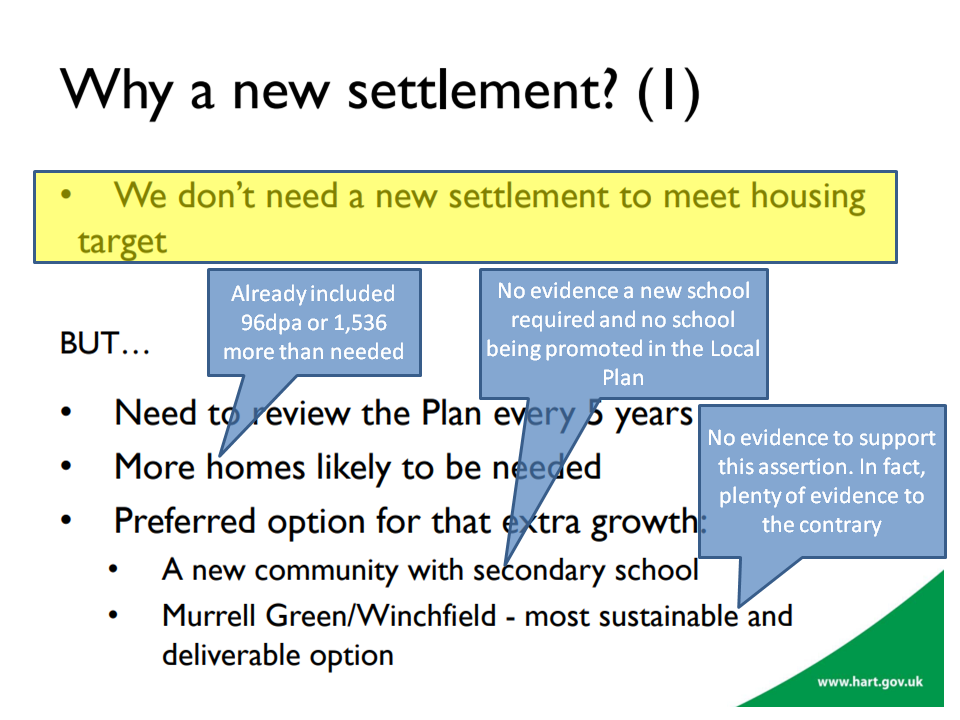
Not only that, the council themselves admit that the housing supply is under-estimated.
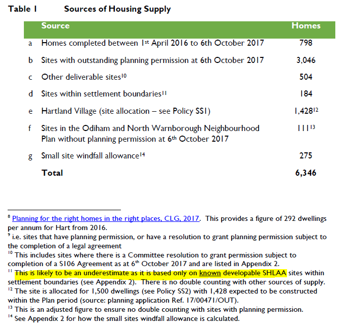
And even this under-estimate does not include housing supply identified in the Winchfield and Hartley Wintney Neighbourhood plans.
The combination of the over-inflated housing demand numbers and the under-stated housing supply numbers mean that the new town simply is not required.
The new town proposal is unsustainable
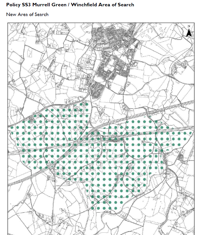
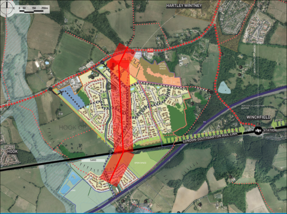
The area of search identified in the Local Plan contains a very wide area, consisting of the areas known as Murrell Green and Winchfield.
We don’t need Hartley Winchook new town so why is it in the Local Plan?
The attempts at sustainability appraisals of the Murrell Green and Winchfield sites have been poor, but nevertheless have demonstrated some very significant weaknesses that cannot be overcome.
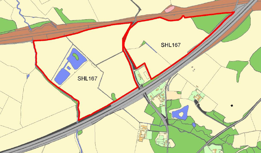
SHL167 SHLAA Map – Beggars Corner, Winchfield, Hart District, Hampshire
Let’s deal with Murrell Green first. Part of the site, known as Beggars Corner was the subject of a planning application for a Solar Farm. This was refused on the grounds that it would spoil the views from Odiham. It is difficult to see how a 1,800 unit development would be any less intrusive than a solar farm. Moreover, that planning application identified that part of the Beggars Corner location is former landfill and some of it has unknown contents. This does not appear to be a suitable location on which to build new houses, or indeed form part of a SANG.
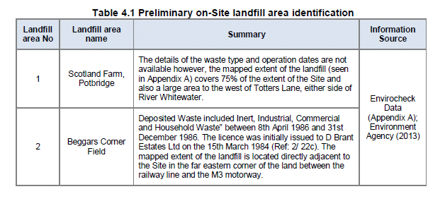
SHL 167 Landfill details Beggars Corner, Winchfield, Hart District, Hampshire
The sustainability appraisal conveniently did not cover this part of the proposed Murrell Green development.
Moreover, the SA did not manage to discover that there is a Major Accident Hazard Pipeline crossing the site. Not only that, the developer’s proposal included a secondary school sited right on top of the pipeline. After examination of the HSE rules regarding such installations, I conclude that neither houses nor schools will be able to be built within up to 100m of that pipeline. I also understand that roads should not cross such pipelines either. See analysis here.
Murrell Green development with high pressure gas pipeline
When one adds in other constraints such as SINCs, proximity of a high voltage power line, the railway and the M3, it appears as though the Murrell Green part of the area of search is not suitable for large scale development.
Turning to the Winchfield part of the area of search, it should be noted that the Winchfield sustainability assessment had to be extracted from HDC by FOI request. It can be found here.
The first point to note is that much of land in the Winchfield area of search is not in fact for sale. This comprises the central swathe known as Talbothay’s Farm plus other areas. Immediately, this leads to the conclusion that it won’t be possible to plan for a coherent settlement if the central part is not available.
In addition, the main areas considered to be constraints in the SA report were:
- Historic Environment
- Bio-diversity
- Landscape
- Water Quality
- Flood risk
More detail on this can be found here. Other spurious claims were made in the SA, such as the claim that building a “renewable and low-carbon energy generation and transfer” plant will diversify energy supply. What they mean is building a wood-burning power station utilising locally sourced timber (p74). Such a plant would be extremely undesirable since burning wood produces more CO2 than burning coal, and none of the proposed master plans include such space for such a plant. Plus, of course, I don’t think many people would support chopping down Bramshill forest to fuel such a plant. This claim was used to indicate that Winchfield was somehow more sustainable than other potential locations.
They also claim that building 3,000 new houses, with associated traffic will somehow “reduce the
emissions of greenhouse gases and manage the impacts of climate change”. Again, complete and utter nonsense.
They also say there was some evidence of wet ground at the far east of SHL183, but “no other obvious evidence of current or past flooding”.
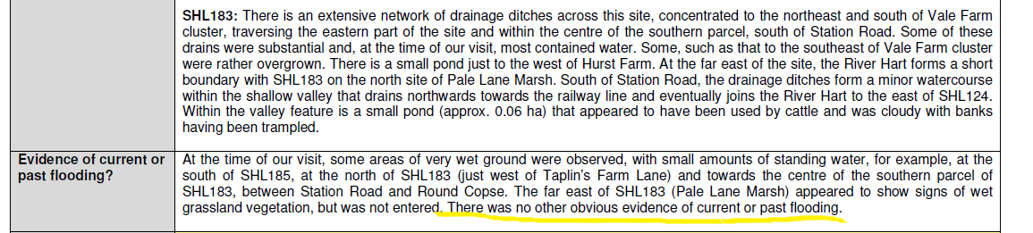
This is of course complete nonsense. The detailed assessment also says there’s only a one in 30 year chance of surface water flooding. The area of Taplins Farm Lane near the railway bridge flooded three times in 2016 alone. Evidence documenting the flood events can be found here (4 Jan) , here (7 Jan), here (9 March on Station Road) and here (28 March due to #StormKatie). I also understand that a similar area has flooded again in January 2018. These are obviously more than one in 30 year events.
The area east of Winchfield fared less well than Murrell Green in the sustainability assessment even with the grossly understated the flood risk. And of course there were other issues with Historic Environment, Bio-diversity, Landscape and Water Quality. It is difficult to see how this could deliver a significant number of houses.
The area west of Winchfield was ruled out of the sustainability assessment, because it is a more peripheral location relative to the train station, does not offer a central focus and is in close proximity to Odiham SSSI. It therefore offers little prospect of significant housing development.
It is clear that there are very considerable constraints even before considering the infrastructure problems.
Hart has not put together proper estimates of the costs of infrastructure; despite saying it would do so.
We have made several estimates that can be found here, here and here. Essentially, if a new motorway junction is required, the costs will be in excess of £300m. If the new junction is not required, the costs will be at least £200m. A rough schedule of requirements includes:
- Secondary school and three primary schools
- New sewage works
- Power station (as per SA)
- Improved drainage
- Re-routing or burying of electricity power lines
- Railway station upgrade to extend platforms and car park (or relocate)
- The bridges that carry the railway over Station Road, Taplins Farm Lane and Pale Lane will all need to be upgraded in some way
- New big roundabouts at either end of the B3016
- New smaller roundabouts from B3016 and A30 to the new town, new roundabout to join Pale Lane and the A323, new roundabout on A287/Crondall Road and at Pilcot Road/Hitches Lane
- New or widened roads at Bagwell Lane, Taplins Farm Lane/Church Lane, Station Road, Pale Lane and Chatter Alley/Pilcot Road. Plus many ancient hedgerows will have to be relocated.
- Potentially widening the A30 around Phoenix Green on the approach to artHHartley Wintney
- New healthcare facilities
- New sports and community facilities
If this is a 5,000 dwelling new town, with 40% ‘affordable’, the remaining market houses might be expected to generate £15-20K per unit of S106/CIL. This would amount to around £45-60m. This is well short of the funding requirement and therefore might be expected to make the existing infrastructure funding gap worse.
Taken together, it is difficult to see how such a new town could be either sustainable or viable. Indeed, it is notable that in the three years of this saga, with many Hart Council members being supportive and apparently developers becoming anxious, no planning application has been made. Perhaps that’s because the developers also realise this is a pipedream.
Secondary school unnecessary and not in a suitable location
A number of councillors have made a fuss about a new settlement bringing a new secondary school. The trouble with this is that they have yet to provide a shred of evidence that a new secondary school is in fact required.
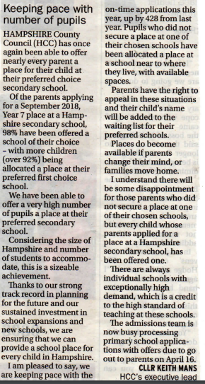
Back in 2015, Hampshire’s forecast went as far as 2018 and they were predicting a surplus of places up to 2018. They also forecast a falling birth rate and a significant number of existing pupils attending Hart schools from outside the district.
In 2017, HCC published a new school place plan that showed an overall surplus of places in both secondary and primary schools up to 2021.
A recent letter from a Hampshire Councillor shows that 98% of Hampshire secondary pupils have been allocated a place at a school of their choice for the next academic year.
So, having established that a new school is probably not required, we must now address the proposals that have been put forward over the past three years for the sites of new secondary schools.
First, we had Barratts in 2014 putting up a proposal to place a new school right next door to an institution housing sex offenders.
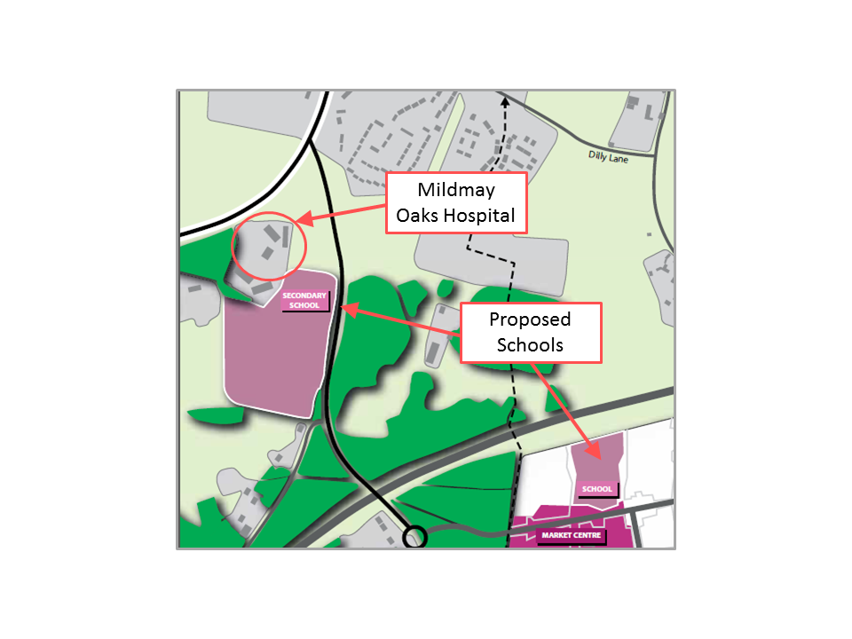
Proposed school next door to Mildmay Oaks Hospital that held escaped child sex offender
Then we had the proposal, described above to build a secondary school right on top of the high-pressure gas main running through the Murrell Green site.
More recently we have had another proposal from promoters of Winchfield which placed the secondary school directly under the high-voltage power lines.
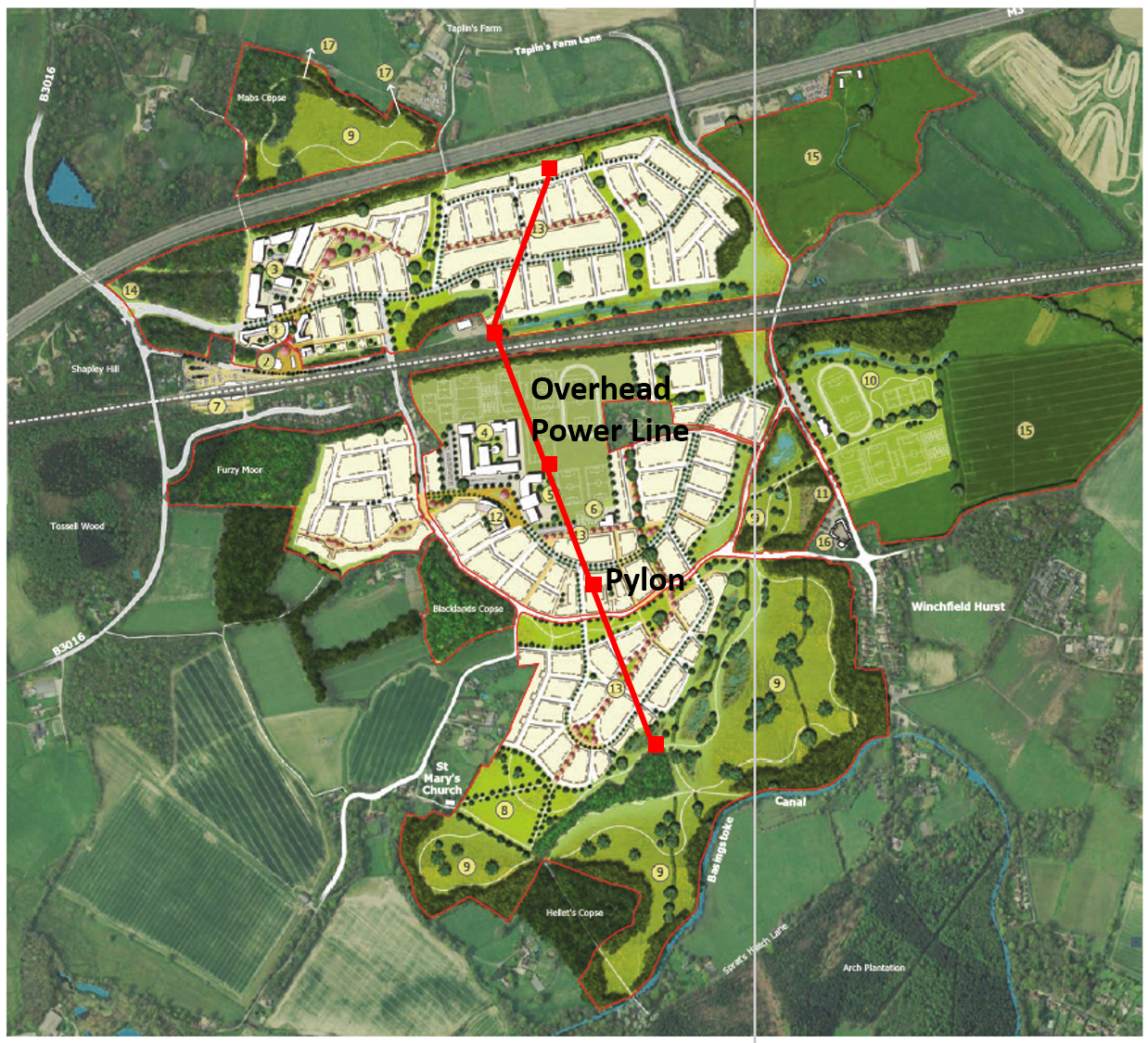
Winchfield Garden Community Master Plan with pylons and powerline
If after three years of trying, they cannot find a suitable location for a secondary school, one does have to come to the conclusion that they never will.
In conclusion, it is apparent that we don’t need a secondary school, and none of the developers involved have managed to find a suitable location.
Coalescence
The area of search is very wide. It borders Hook to the west, Hartley Wintney/Phoenix Green to the north east and comes very close to the Edenbrook development and the proposed Pale Lane development to the east. The bulk of the proposal also comes very close to Dogmersfield.
In other areas of the Local Plan, the council have been quite assiduous in defining strategic gaps. They have produced no such gaps around the new area of search, nor to the east of Hook or anywhere around Hartley Wintney. Nor are any gaps proposed to the north west of Fleet.
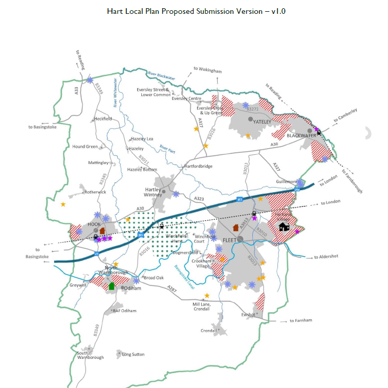
Hartley Winchook leads to no strategic gaps around Hartley Wintney nor to the east of Hook
If they are allowed to go ahead with this area of search, unconstrained by strategic gaps, there is a strong risk that they will come up with proposals that lead to coalescence of our proud villages.
Breaks the Objectives elsewhere in the Hart Local Plan
Elsewhere in the Local Plan, Hart have come up with a number of objectives. These are reproduced below with my comments in bold on how these proposals break those objectives.
- To support the vitality and viability of the District’s town and village centres to serve the needs of residents. Adding a new settlement will draw retail traffic away from our existing urban centres, most notably Fleet, and lead to even faster degeneration of Fleet as a retail destination. This can hardly be described as supporting vitality and viability.
- To conserve and enhance the distinctive built and historic environment in the District including the protection of heritage assets and their settings. The proposed area of search includes a Norman church dating back to the Domesday Book and several SSSI’s including at Odiham and Basingstoke Canal. There are numerous other distinctive and historic buildings. Building a new settlement right next door to these valuable assets with neither conserve nor enhance the environment.
- To protect and enhance the District’s natural environment, landscape character, water environment and biodiversity, including ensuring appropriate mitigation is in place for new development to avoid adverse impacts on the Thames Basin Heaths Special Protection Area (TBHSPA).Building a new settlement in one of the most attractive parts of the district, containing many woodlands and hedgerows supporting much wildlife such as deer and kingfishers, used by many for leisure and recreation will actively damage the landscape and biodiversity.
- To provide measures for adapting to the impacts of climate change and minimising the contribution of new development to the causes of climate change, including reducing the risk of flooding by directing development away from areas at risk of flooding, and using opportunities offered by new development to reduce the causes and impacts of flooding from all sources. We have already established that the SA grossly under-stated the flood risk in the area known as Winchfield East, yet they are proposing to build on this area, directly against their stated objective.
- To promote healthy and sustainable local communities through protecting and enhancing community, sport, health, cultural, recreation and leisure facilities, and through the delivery of a multi-functional green infrastructure network across the District. We already have a multi-functional green infrastructure network in Winchfield used for recreation and leisure. Building on it will destroy it, again directly contravening their own objective.
- To maintain the separate character and identity of settlements by avoiding development that would result in their physical or visual coalescence. Again, we established the risk of coalescence earlier. This proposal, if implemented would effectively create a single urban conurbation from Hartland Park in the east, across Fleet and Hartley Wintney to Hook in the west. This is an appalling prospect, again directly breaking their own objective.
Remedy: I would propose that Policy SS3 is removed entirely from the Hart Local Plan, and consequent amendments are made to SS1.
Went in the site today, thanks again to David for doing the hard yards to get a suggested response. Have worded it for myself and submitted, but thanks to David for pulling the info together
Pingback: Hart Local Plan: No plans for infrastructure | We Heart Hart