Where is the draft Hart Local Plan?

Hart Local Plan - Keep Calm and Wait until 26 April

Hart Local Plan – Keep Calm and Wait until 26 April

Regular readers maybe wondering what has happened to the Hart Local Plan. On February 9th, Hart Cabinet agreed to a spatial strategy as part of the draft Local Plan that was due to go out to consultation in March. Obviously, there have been further delays. This is what we now understand to be the position:

Hart Local Plan timetable

The draft local plan will be released 26 April for a six-week Reg 18 consultation period after a briefing session with Parish Councillors on the 25th. There will be roadshows at the main settlements. Every house in the district will receive an A5 leaflet advising them of the consultation.

The Reg 19 process will follow in about November with submission of the full plan to the Secretary of State in mid-February 2018. All responses during the Reg 18 will be made public including the names of the individuals but with no contact details.

Hart Local Plan Headlines

Hart Council have decided to build 10,185 houses up to 2032 of which around 50% have already been built or granted permission. Please note that this number is far higher than 8,022 target the recently published Strategic Housing Market Assessment and more than double the requirement generated from demographic change. The numbers are now correct as of 31 January 17 and include all office conversions which have been approved.

Housing Numbers by area

  • Fleet 200 – mostly through office redevelopment
  • Hook was 200 now 10 from office redevelopment plus another 87. However, developers may chance their arm again with Owens Farm (750), and of course around half the Murrell Green site is in Hook Parish.
  • Sun Park 320
  • Hartland Park (Pyestock) 1500. Fleet town council have apparently made the point that the site offers only 20% affordable homes and the density per hectare is up to 97 in places which is equivalent to city centre densities which is of concern to them. OUr view would be to make the most of available brownfield sites.
  • Murrell Green 1800 but with challenges. There are 4 promoters and it will be some 3 to 4 years before planning permission is approved. It includes the site for a secondary school but there won’t be enough developer contributions to pay for it. New school funding rules mean that Hampshire can’t pay for it either.  It’ll probably be an Academy at a cost of circa £36 million. So we get a site for a school, but no money.
  • Crondall 66
  • Crookham Village 100 + 64 predominantly the care village
  • Eversley 124 on two sites
  • Heckfield 86
  • Long Sutton 10
  • Odiham 119 as per NP
  • Hartley Wintney 0. It seems odd that HW’s Neighbourhood Plan will be ignored. It should be noted that Murrell Green directly abuts Hartley Wintney Parish and about half of the proposed Pale Lane (Elvetham Chase) development is in HW parish.
  • South Warnborough 34 on two sites
  • Yateley 88
  • An additional 50 via rural exceptions and a further 290 from windfall.
  • Interestingly, no mention of Winchfield, or their Neighbourhood Plan, but roughly half of Murrell Green is in Winchfield Parish.
  • Apparently, Bramshill will be very difficult to develop because of all the complications with the Grade 1 listed site.

Other news

Apparently East Hants have done such a stellar job on the Local Plan, the Planning Policy team is now back in house at Hart, reduced in size from 8 to 2.

There is a risk that developers will continue to pursue Pale Lane and take it to appeal before the Local Plan is adopted.

We await the results of the Grove Farm (Netherhouse Copse) appeal in June.
Lib Dems come out against Winchfield New Town

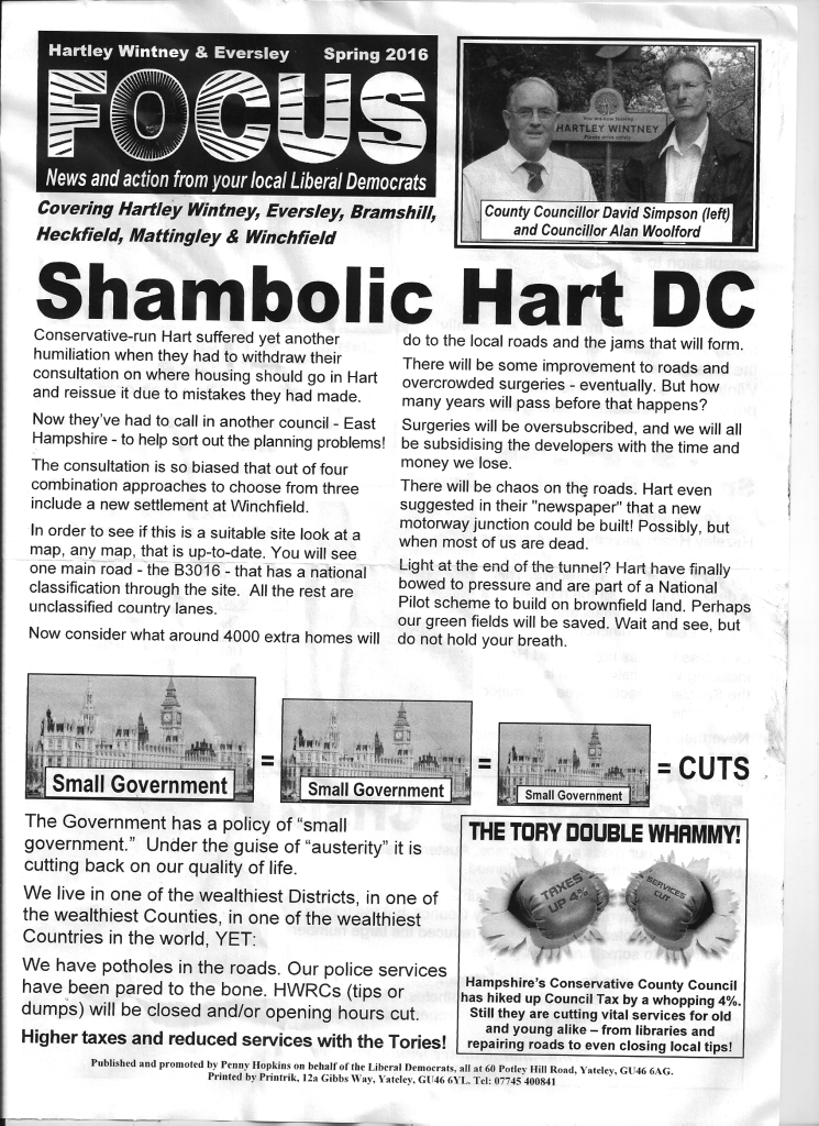
Liberal Democrat Focus Hartley Wintney + Eversley Spring 2016

The local Liberal Democrats have published a newsletter for Hartley Wintney and Eversley (also covering Bramshill, Heckfield, Mattingley and Winchfield) strongly condemning the idea of a new town at Winchfield.  A full image of the newsletter can be found here. This is an important issue for the Hart Local Elections 2016.

They are silent on their position on the new brownfield site at Pyestock (aka Hartland Park).  It isn’t clear whether this is a unified position of all Lib Dems across the district, or just the position of those standing in Hartley Wintney ward. In particular, it isn’t clear whether this represents a reversal in the position of those Lib Dems who voted in favour of the new town in November 2014.

We have contacted the NE Hants Lib Dems to ask for a full position of the current candidates on both the new town and Pyestock, but have yet to receive a reply.  Nevertheless, we have updated our summary page to update the position of the Hartley Wintney candidate. We will update the other candidates once we hear from the NE Hants Lib Dems or if anyone sends us leaflets from other wards outlining the Lib Dem position.

[Update] The Lib Dems have issued a leaflet, supporting Pyestock [/Update]

Which parishes have seen most development Hart District?

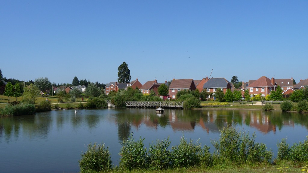
Elvetham Heath near Fleet, Hampshire

Elvetham Heath near Fleet, Hampshire

There has been much controversy about how much development there has been in Hart District over the past few years, so inspired by a post on the Winchfield Action Group site, we thought we’d take a closer look at the data.

We have compiled a list by parish and ward of the number of dwellings in each area in 2001 and 2011, according to the census and the results are shown in the table below:

ParishWard2001 Census (Dwellings)2011 Census (Dwellings)% Increase
Blackwater & Hawley177218675.4
Bramshill9863-35.7
Church Crookham330933280.6
Crondall6887387.2
Crookham Village156316304.3
Dogmersfield1241283.2
Eversley5996508.5
Ewshot2292352.6
FleetCentral2235256514.8
FleetCourtmoor188819282.1
FleetNorth (inc Elvetham Heath)13602947116.7
FleetPondtail182018984.3
FleetWest185719786.5
Fleet Total91601131623.5
Greywell1041040
Hartley Wintney212622224.5
Heckfield137135-1.5
Hook2718311114.5
Mattingley2322382.6
Odiham & Long Sutton271228806.2
Rotherwick2052123.4
South Warnborough21326223
Winchfield2392587.9
Yateley79427959.2
Total34170373369.3

It should be noted that the data only runs up to 2011 and so misses out most or all of certain developments such as QEB in Church Crookham, Dilly Lane and Rifle Range Farm in Hartley Wintney, Edenbrook and the planned new developments at Hawley Park Farm, new development to the North East of Hook and at Watery Lane.

It does show that the area with the largest increase is what was known as Fleet North, which has now been split after incorporating Elvetham Heath.

It is not really for us to point fingers at different areas of the district.  We will let readers make up their own mind and draw their own conclusions from the data.

If anyone finds an error in any of the data, then please do get in touch and we will make any corrections that are needed.

[Update]

I was asked to provide updated data of the permissions and completions since 2011.  There is no easy way to get this data.  This is a copy of what I received:

The majority of the information (with details of location and parish) on housing completions and permissions for the next few years can be found in the following two published documents :

Appendix 2&3
http://www.hart.gov.uk/sites/default/files/4_The_Council/Policies_and_published_documents/Planning_policy/Hart%205%20yr%20supply%20statement%20at%201st%20October%202015.pdf

And http://www.hart.gov.uk/sites/default/files/4_The_Council/Policies_and_published_documents/Planning_policy/Final%20Dwelling%20Completion%20Figures%202014-15_for%20website.xlsx

It’s regrettable  that you only used figures from the superseded five year land supply (2001-2011) calculation in the Interim Housing Delivery Strategy which was superseded by the Five Year Land Supply Position Statement:
Five Year Housing Land Supply Position Statement, 1st October 2015
2014-15, and the Completions list from Hampshire County Council (1st April 2015) both of which were linked on the  council website “Current planning policy and guidance” referring to the local plan consultation, and also discussed at a council meeting.

I’m glad got said you’d incorporate the latest numbers, and look forward to seeing this. I believe you’ll find disproportionate housing allocation to the North and East of the region whilst minimal development in the centre, West or south.

I can confirm that I used neither of the Housing Land Supply documents to produce the table above.  As the original post says, the source for the above is the census.

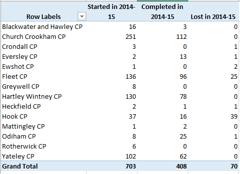
The link to the pdf just gives a long list of sites in a form that it is impossible to analyse in any meaningful way, least of all by parish.  The spreadsheet contains a list of starts, completions and losses for 2014-2015, a summary of which by Parish is shown below.

Dwellings started completed and lost in Hart District 2014-15

[/Update]

Please help Hart fend off an extra 1,600 houses from Rushmoor

Is this what we want Hart to turn into?

Is this what we want Hart to turn into?

Rushmoor Borough Council has published a draft Local Plan where it proposes to build only 8,200 of its assessed need of 9,822 houses over the plan period.  It is clear that Rushmoor is seeking to offload the remaining 1,622 houses on to Hart District.

We need to oppose this move and We Heart Heart have produced some materials to help you do this easily.  Our voice will have greater weight if we can get more Hart residents to comment on Rushmoor’s plan than Rushmoor residents. Please follow the simple process below:

  1. Download the Local Plan response form from the link below.
  2. On page 3, fill in your name and contact details and type your name and date in the boxes at the bottom of the page.
  3. Review the comments made and feel free to add, amend or delete as you see fit.
  4. Save the document, attach it to an email and send to [email protected]
  5. Share a link to this page to all your friends and family as well as any sports clubs or community groups you belong to via word of mouth, email, Facebook and Twitter and ask them to put in a response and share this page again.
  6. If you have not already done so, please sign and share our petition too.
Rushmoor Local Plan Response Form

A summary of the arguments we are putting forwards is outlined below.

Slippery slope to taking more housing than the other districts

The proposal to take an additional 1,622 houses from Rushmoor puts us on the slippery slope to accepting a further 1,400 houses from Surrey Heath such that Hart District ends up having to build the most houses in the Housing Market Area.


Hart DistrictSurrey Heath BoroughRushmoor BoroughTotal Housing Market Area
Original SHMA7,5347,0579,82224,413
Proposed Transfers3,022(1,400)(1,622)0
New Total10,5565,6578,20024,413


This will impact all of our districts including Blackwater and Hawley; Bramshill;  Church Crookham; Crondall; Crookham Village; Dogmersfield; Elvetham Heath; Eversley; Ewshot; Fleet; Greywell; Hartley Wintney; Heckfield; Hook; Mattingley; North Warnborough; Odiham; Rotherwick; South Warnborough; Winchfield; and Yateley adding additional pressure to an already difficult situation and make it more likely we have to accept both a new town and urban extensions on our beautiful green fields and countryside.

Hart and the rest of Housing Market Area are being asked to build too many houses

The whole Housing Market Area (HMA) should reduce the assessed need by 7,800 units which would reduce the pressure on Hart directly and remove the need for Surrey Heath and Rushmoor to ask us to build >3,000 houses for them. This is discussed in more detail here.

Rushmoor isn’t making best use of its brownfield sites

This is discussed in more detail here and here. As can be seen, if Rushmoor gets more creative with Wellesley and plans to build on the sites it has already identified, there is potential capacity for over 30,000 dwellings, more than three times its (overblown) assessed need.   It surely cannot be too much to expect them to find the 1,600 houses they say they can’t build out of this wealth of opportunity.  Rushmoor Borough Council should re-visit its planned densities and seek to meet all of its assessed need within in its own boundaries.  It could then make some sites available for neighbouring rural districts in line with a recent survey of Hampshire residents seeking to protect rural areas.  Neighbouring districts could be approached to provide SANG capacity if required.  Rushmoor should also take a closer look at all the vacant sites in the district and seek to convert them to residential use.

Rushmoor’s Employment Land Review is overblown and seeks to protect more employment land than is necessary.

This is discussed here.  It is also clear that past forecasts got it wrong as evidenced by the large number of vacant office blocks and empty shops across Hart District.  If the ELR was reduced to more sensible levels they could free up more land for housing.

Indeed, even if you accept the overblown employment forecasts, there will be a surplus of nearly 600K sq m of employment space at the end of the plan period, covering around 195 Ha.  Yet Rushmoor seeking to protect 96 Ha of land whilst asking Hart to build 1,600 houses on green fields.

Rushmoor’s infrastructure plans are not credible

We posted here that Hampshire as a whole has a £1.9bn infrastructure funding deficit, with Rushmoor’s share of that being £80m.  Rushmoor makes no mention of this deficit in its draft Local Plan.  Hart’s own numbers show an infrastructure deficit of £78m.  All of these numbers are probably an under-statement given they were all produced before the scale of development now proposed was known.  This is in contravention of NPPF para 177 that says there must be a “reasonable prospect” of delivering the required infrastructure alongside housing:

“It is equally important to ensure that there is a reasonable prospect that planned infrastructure is deliverable in a timely fashion. To facilitate this, it is important that local planning authorities understand district-wide development costs at the time Local Plans are drawn up. For this reason, infrastructure and development policies should be planned at the same time, in the Local Plan”

Finally, they don’t even attempt to quantify the extra infrastructure Hart would need to build the extra 1,600 houses nor do they make any offer to fund any of that extra cost.

Rushmoor not planning to meet the needs of the ageing population

Figure 10.15 of the SHMA sets out the need for specialist housing and registered care places for the HMA and Rushmoor.  This states Rushmoor must build 710 sheltered and extra care units as well as provide an extra 600 registered care places. Their draft Local Plan makes no mention of the extra registered care places and sets no target for the sheltered and extra care units.  This is in contravention of NPPF para 50 which states:

“local planning authorities should…plan for a mix of housing based on current and future demographic trends, market trends and the needs of different groups in the community (such as, but not limited to, families with children, older people, people with disabilities, service families and people wishing to build their own homes)”

Therefore the Rushmoor draft Local Plan runs the risk of being found unsound and should be revised.


In conclusion, the Rushmoor draft Local Plan contains many serious flaws and needs to be revised.

Link


Launch of We ♥ Hart Petition

The We Heart Hart Campaign (aka We Love Hart and We ♥ Hart) have now started a campaign on 38 degrees to petition Hart Council to change its approach to the Hart Local Plan. This petition can be found here: https://you.38degrees.org.uk/petitions/we-hart.

Please support this petition by signing it and sharing it with all your friends via e-mail, Facebook and Twitter.

We need to protect all of our parishes including: Blackwater and Hawley; Bramshill;  Church Crookham; Crondall; Crookham Village; Dogmersfield; Elvetham Heath; Eversley; Ewshot; Fleet; Greywell; Hartley Wintney; Heckfield; Hook; Mattingley; North Warnborough; Odiham; Rotherwick; South Warnborough; Winchfield; and Yateley from this invidious plan.

We Heart Hart Campaign Logo

We Heart Hart Campaign Logo

Hart District

Hart is a beautiful district made up of a mixture of large urban settlements such as Fleet and smaller village type settlements such as Odiham. The space around these settlements is largely made up of green fields and woodland which give Hart its essential rural feel.

In December 2014, for the fourth year running, Hart was named the best place to live in the country in a survey by the Halifax. Each settlement has a distinctive community feel; the quality of the schools is excellent and the 84 square miles of green fields and wooded landscape are a perfect example of England’s green and pleasant land that is excellent for wildlife, cycling and walking.

This essential nature of Hart is now being put under pressure by the National Planning Policy Framework and Hart Council’s response to it. In the years up to 2031, Hart has to build another 7,500 homes. Hart Council is proposing to meet the bulk of this need by building a new settlement in the heart of Hart at Winchfield destroying over 700 acres of green fields and woodland in the process.

We are mounting a campaign against these proposals because we believe the Strategic Housing Market Assessment that gave rise to the need for 7,534 extra houses (not to mention the extra 3,100 houses from Surrey Heath and Rushmoor) is flawed and Hart’s response to this is inappropriate.

This is putting all of the parishes of Hart District at risk including:

Blackwater and Hawley; Bramshill;  Church Crookham; Crondall; Crookham Village; Dogmersfield; Elvetham Heath; Eversley; Ewshot; Fleet; Greywell; Hartley Wintney; Heckfield; Hook; Mattingley; North Warnborough; Odiham; Rotherwick; South Warnborough; Winchfield; and Yateley.