Ideas to oppose the Watery Lane Development in Church Crookham

Some of the opponents of the proposed Watery Lane development in Church Crookham have criticised We Heart Hart for not joining them in opposing building a housing estate there.  We cannot get involved in each and every planning application, but the material below outlines what we believe would be useful material for Face IT and other groups to use as they see fit to add to their case.

1. We don’t need this development

Hart is being asked to build too many houses, because the SHMA is flawed.  It starts with the 2011-based population projections, whereas the 2012-based projections would reduce the starting point by 1,800 dwellings (SHMA appendices p75).  The jobs forecasts are too optimistic, calling for a near doubling of the job creation rate over the plan period.  See the links below for more detail:

https://wehearthart.co.uk/2015/06/hart-is-being-asked-to-build-too-many-houses/

https://wehearthart.co.uk/2015/11/independent-expert-says-we-are-being-asked-to-build-too-many-houses/

https://wehearthart.co.uk/2015/05/revised-submission-to-owens-farm-hop-garden-road-appeal/

As a result of the over-stated need in the SHMA, the current land supply statement understates the land-supply position, therefore the Watery Lane development is not needed now.

2. Brownfield Solution

There is an alternative brownfield solution to meet the housing needs of the district. Our local MP also supports a brownfield solution:

https://wehearthart.co.uk/2015/11/there-is-a-brownfield-solution-to-harts-housing-needs/

https://wehearthart.co.uk/2015/10/ranil-says-no-to-winchfield-new-town-and-yes-to-brownfield/

3. Wrong type of Housing in the Wrong Place

A development such as Watery Lane would build the wrong type of housing in the wrong place to meet the needs of the district. Hart’s policy is to build 40% affordable and 60% market housing, or a split of about 3,014 affordable and 4,520 market to meet our overall need of 7,534. The SHMA (Figure 9.8) calls for 40.8% 1-bed and 33.2% 2-bed properties from our affordable housing target and 6.7% 1-bed and 28% 2-bed properties from our market housing target. This gives a total target of 1,532 1-bed and 2,266 2-bed properties.  No data has yet been forthcoming on how well or badly we are doing against these targets, but perhaps Face IT could join We Heart Hart in asking Hart to produce the information to allow us to know one way or the other.  More traditional housing estates in the countryside are likely to under-deliver on both affordable and smaller properties.

Similarly, the SHMA (Figure 10.15) calls for around 2,500 specialist units for the elderly, split into various categories to be built in Hart under the Local Plan.  We do not know how many have been built or permitted to date, but again it is self-evident that a housing estate in the country would not deliver specialist units for the elderly. Again, perhaps Face IT can join We Heart Hart in requesting that this information is released.

We do hope that the team opposing Watery Lane find this information helpful.

Response to Hook Action Against Over Development

Which would you rather preserve - derelict eyesore or our wildlife?

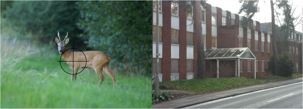
Which would you rather preserve – derelict eyesore or our countryside and wildlife?

Hook Action Against Over Development have written an article on their website which has been shared on Facebook, criticising both our support of a brownfield solution to our housing needs and the statement from the CPRE saying that the Winchfield New Town proposal was the worst site and the worst option for development.

We re-produce their article below, together with our responses in blue:

There has been a lot of talk about brownfield development and some claims that a new settlement is not necessary because brownfield housing development can provide for all of Hart’s housing needs. Brownfield housing development is the reuse of property or land for residential use where it was previously used for something else, for example office space, industrial land, military use or farm buildings.

Yes, we do believe that all of Hart’s remaining housing need can be met from brownfield sites, and we have set out the case and our plan here and here.  This draws on sites in the SHLAA at only ~26 dwellings per hectare (dph) and the work of the Stonegate Report, plus we have added the civic area that Fleet Future recommended for redevelopment and Fleet Town Council have raised their council tax to fund the costs of preparing a redevelopment plan.

One group in particular from outside of Hook is putting forward the suggestion that the Hart consultation is a simple choice between brownfield and greenfield development. But no matter how much they repeat it does not make it any more true. The CPRE, an organisation with laudable aims, appears to have now fallen for this fiction and hijacking of the term “sustainable development”.

We believe they are referring to We Heart Hart.  We believe the CPRE have not put forward an actual plan, but have clearly stated that they think that a new town at Winchfield is the worst site and worst option for development in Hart.  Sustainable development was defined by the Sustainable Development Commission as:

“Sustainable development is development that meets the needs of the present, without compromising the ability of future generations to meet their own needs.”

The concept of sustainable development can be interpreted in many different ways, but at its core is an approach to development that looks to balance different, and often competing, needs against an awareness of the environmental, social and economic limitations we face as a society.

We believe that sustainable development does not include concreting over the equivalent of 25 football pitches per year of green fields and leaving untouched, vacant, decaying office blocks. A new settlement would compromise future generations by needlessly concreting over hundreds of hectares of green fields, depriving future generations of the health benefits of the countryside. The economics of the proposals don’t stack up, requiring ~£350m of infrastructure spending, money that neither Hart nor Hampshire County Council have, especially now that HCC is facing an £81m per annum funding deficit. 

Hart’s housing strategy is brownfield first, but Hart cannot propose development on sites that are in commercial use or that have not been put forward for housing. If they were to do so then the Local Plan would fail inspection again at the first hurdle and this would be a disaster. Even hypothetically utilising these unavailable brownfield sites would demand construction at inner city density in order to meet Hart’s objectively assessed housing need. We cannot believe that CPRE are promoting building at such a density in Hart. That would not be sustainable.

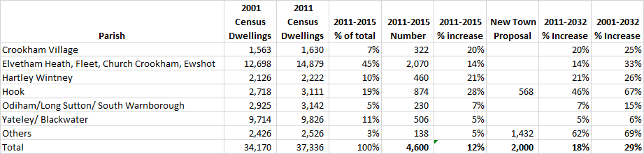
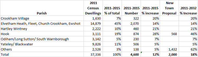
We agree that sites need to be developable and eventually deliverable and nobody wants to see the Local Plan fail. Back in September, Hart Council said that they thought the brownfield capacity was 1,800 units.  Miraculously, this has fallen by 75% to only 450 units in the consultation. However, as described above, most of the sites we have put forward are in the SHLAA and in no worse state of deliverability than those put forward for consultation. The other sites are in the Stonegate report and we understand Stonegate are working hard to secure these sites.  The average density for the SHLAA sites is less than Hart’s planning rule of thumb at 26dph, and the Stonegate sites are at no higher density than developments that Hart has granted permission for such as the McCarthy & Stone’s recent development on Fleet Road which many people think is an attractive building.

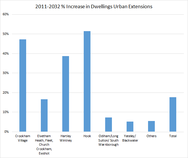
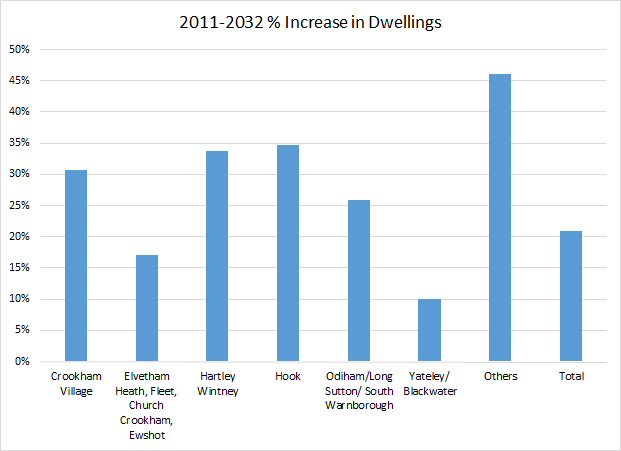
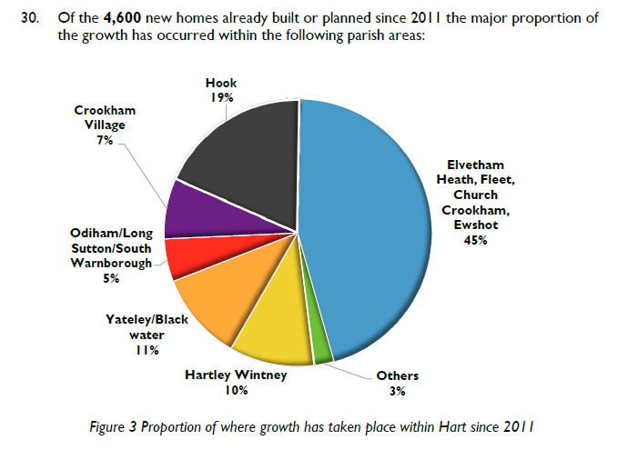
Hart are actually consulting on which of Hart’s green fields should be selected for housing in the event that there is insufficient brownfield land to meet the housing need. Given the vast expansion of the existing towns and villages in Hart already, with Hook alone having a 25% expansion approved for this Local Plan period, the only suitable and truly sustainable option is a new settlement to allow for a planned increase in infrastructure. Just expanding existing towns and villages either piecemeal or with “urban extensions” is still building on green fields, but in a way that will not provide the opportunity to build extra schools, roads and health facilities that the thousands of new Hart residents will require. That would not be sustainable.

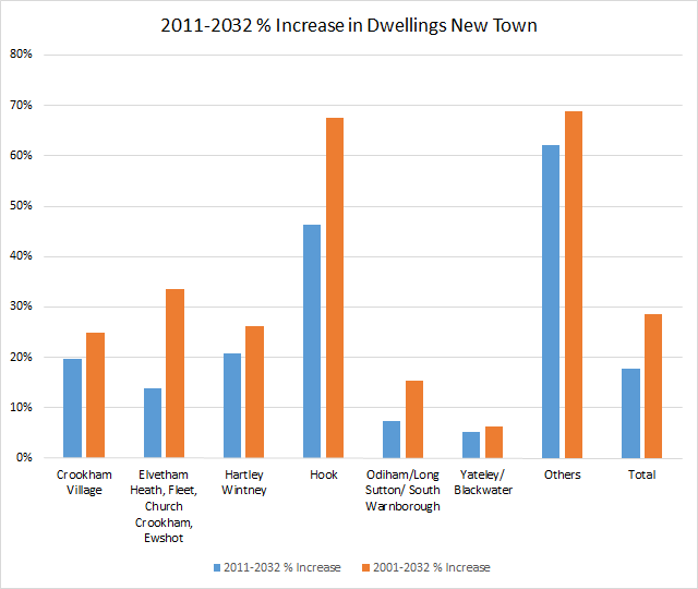
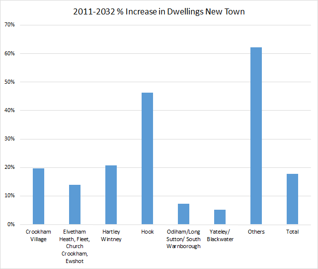
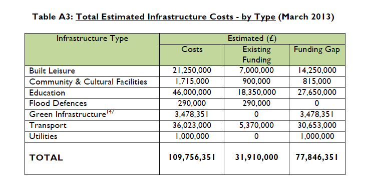
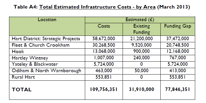
The proposed new town will in fact deliver over 1,800 houses in Hook Parish, which is more than the proposed urban extension and more than the undeveloped brownfield sites.  To be clear, we do not support urban extensions either because we believe all of the remaining need can be met on brownfield sites. The infrastructure costs for a new town do not stack up and a new town will do nothing to close the large £12.2m existing infrastructure funding gap in Hook, and £20.7m gap in Fleet and Church Crookham. No evidence has been presented that we need a new secondary school and the funding for a new town will not address existing road bottlenecks, nor will there be sufficient funding to address the roads requirements of a new town. We repeat, we do not believe concreting over 25 football pitches each year is at all sustainable.

Elimination of all potential commercial property space in Hart is in fact extremely short-sighted. Even the Enterprise M3 Local Enterprise Partnership which is urging more housing would not want to see commercial space becoming rare and expensive. There is already an acknowledged shortage within Hart of small business units and light industrial space. Larger available office space provides options for small local businesses to grow without leaving the area. A thriving local economy needs a balance of housing and business to provide employment opportunities locally and avoid all of these new residents having to take to the roads and railways to commute out of the area for work on already busy transport links. That would not be sustainable.

Nobody is saying that all of the vacant commercial space be handed over to housing.  But even the Employment Land Review, based as it is on the inflated Strategic Housing Market Assessment (SHMA) and the inflated jobs forecasts, suggests that there will be around 600,000 sq m of vacant employment space across the Housing Market Area at the end of the plan period and Rushmoor was planning to “protect” 96 Ha of vacant brownfield sites that simply are not needed. If there was such a shortage of offices or of light industrial space, places like the Murrell Green Estate would not have the big vacancies they currently have. Of course it would be more sustainable to free up some of these spaces and redevelop them for residential use rather than leave them to rot and decay.

There is very little brownfield land in Hart but there is an amusing “brownfield site slideshow”, made available by campaigners whose aim is to push development away from their village, to supposedly “demonstrate” how much brownfield land is available for housing. If you happen to see it, do bear in mind that:

  • Several of the sites are already being developed for housing (and therefore counted in existing housing build numbers!) such as Landata House and Greenwell in Hook, Sun Park and others.
  • Several of the sites are being converted to other commercial uses, e.g. Warehousing at Pyestock and retail development on Fleet Road where M&S are looking to move to an expanded new store.
  • Several of the sites are in fact just one vacant floor(or even a partial floor) in an otherwise occupied office building!

Now perhaps the future really is an office building with some adjacent floorspace being residential, but can anyone imagine this being attractive to either residential or commercial tenants?!

The fact that some of the sites have already been taken up for redevelopment simply proves our case and shows it can be done.  Our brownfield solution has taken account of the sites that are already underway. Work at Hartland Park (aka Pyestock) stopped years ago, and there is no sign of it re-starting.  The owners will not wish to keep an expensive site forever generating no returns. Of course if M&S moves into another Fleet Road site, then they will leave behind a different vacant block to go with the many other vacant units in the Hart Centre.

There are plenty of examples of mixed residential and commercial use, both in this country and on the continent.  Nobody is suggesting this should happen without comprehensive redevelopment.

This current consultation is clearly not about a choice between brownfield and greenfield development, it is about the best way to provide Hart’s required housing with essential supporting infrastructure and only a new settlement can achieve that. For more, please refer to our previous article hookdevaction.org.uk/hart-housing-consultation-restarted-your-action-needed.

The Hartley Winchook new town is not required, it not viable because of the flood risks and the massive, unfunded infrastructure costs, and will not be sustainable in any sense of the word. There is a brownfield alternative, and we should seize that opportunity.


Here are the slideshows of vacant brownfield sites we have found in Hart and Rushmoor:


  • We Heart Hart's Mascot - Bravehart
    We Heart Hart's Mascot - Bravehart


If you would like to ask Hart to abandon the new town and urban extension ideas and create a brownfield solution to our housing needs, we urge you to respond to the Hart District Council consultation about the Local Plan and ask them to think again. We have created a dedicated consultation page, updated our two guides to responding to the consultation and they are available on the downloads below. The comments are designed to be cut and pasted into the boxes provided. It will be very powerful if you could edit the comments into your own words. Please do find time to respond to the consultation and play your part in saving our countryside.

Full version:

Responses to Local Plan Consultation

2 Minute version:

Respond to Local Plan Consultation in 2 minutes

Urban areas not taking their fair share of development 2001-2032 Part 3

Proposed percentage increase in dwellings by parish in Hart District Dispersal 2001-2032

Proposed percentage increase in dwellings by parish in Hart District Dispersal 2001-2032

Our previous posts (here and here) about the level of development that will be faced by the different parishes under the different development proposals put forward by Hart District have been criticised for two reasons:

  1. That the parishes are grouped in to clusters and,
  2. That the analysis does not go back far enough in time

The answer to the first point is that unfortunately, Hart have only provided the development from 2011-2015 in the parish groupings shown, so there is no other way of presenting the data and still maintaining accuracy.

In answer to the second point, we have now incorporated the census data from 2001 into the calculations, so now it is possible to see the percentage increase in the same parish clusters from 2001-2032 and from 2011-2032.  The results in graphical and tabular form are shown above and below. This data for dispersal shows that Fleet, Church Crookham and Crookham Village will not take more proportionate development than many other areas of Hart such as Hook, Hartley Wintney and the “Other” rural districts.  But it does show that Yateley and Blackwater have taken least proportionate development over both time periods and the smaller rural districts would take a very large proportionate increase if this strategy were pursued to the fullest extent.

First, the dispersal approach, the graph is shown above, and the table below:

Proposed percentage increase in dwellings by parish in Hart District Dispersal Table 2001-2032

Proposed percentage increase in dwellings by parish in Hart District Dispersal Table 2001-2032

Second, the urban extension approach below. This shows that Hook will take the largest proportionate development using this approach over both time periods and Crookham Village will also see a very large proportionate increase in housing. Again Yateley and Blackwater are relatively unscathed, with the smaller rural districts taking relatively little proportionate development.  This would point towards a need for some more dispersal towards those districts, but not to the full extent described above:

Proposed percentage increase in dwellings by parish in Hart District Urban Extensions 2001-2032

Proposed percentage increase in dwellings by parish in Hart District Urban Extensions 2001-2032


Proposed percentage increase in dwellings by parish in Hart District Urban Extensions Table 2001-2032

Proposed percentage increase in dwellings by parish in Hart District Urban Extensions Table 2001-2032

And finally, the new town approach. This shows again that Hook parish would bear a large proportionate increase in housing, plus the Winchfield part of “Others” would also bear a massive increase in housing, with Winchfield enduring a 6-fold increase during the plan period, with much more thereafter.

Proposed percentage increase in dwellings by parish in Hart District New Town 2001-2032

Proposed percentage increase in dwellings by parish in Hart District New Town 2001-2032


Proposed percentage increase in dwellings by parish in Hart District New Town Table 2001-2032

Proposed percentage increase in dwellings by parish in Hart District New Town Table 2001-2032

To us, this points to the need to redouble efforts to rebalance the housing proposals and redouble efforts to find a brownfield solution.

If you would like to ask Hart to abandon the new town and urban extension ideas and create a brownfield solution to our housing needs, we urge you to respond to the Hart District Council consultation about the Local Plan and ask them to think again. We have created a dedicated consultation page and updated our two guides to responding to the consultation that are available on the downloads below. The comments are designed to be cut and pasted into the boxes provided. It will be very powerful if you could edit the comments into your own words. Please do find time to respond to the consultation and play your part in saving our countryside.

Full version:

Responses to Local Plan Consultation

2 Minute version:

Respond to Local Plan Consultation in 2 minutes

Urban Areas not taking their fair share of homes part 2

Proposed percentage increase in dwellings by parish in Hart District New Town

Proposed percentage increase in dwellings by parish in Hart District New Town

Further to our post of yesterday, that showed the impact by parish of following a dispersal strategy, we have now created graphs to show the impact by parish of urban extensions and a new town.  In each case, it shows that the urban areas of the district are not taking their fair share of housing.

This demonstrates to us the need to step up efforts to follow a brownfield strategy and re-find the 1,400 units on brownfield sites that Hart lost after saying that 1,800 units on brownfield land could be readily quantified back in September 2015.

First, let’s take at the new town strategy.  The chart showing the %-age increase in dwellings by parish from 2011 to 2032 if we followed a new town strategy to meet the remaining need from now on is shown above.  The table showing how this has been calculated is shown below:

Proposed percentage increase in dwellings by parish in Hart District New Town Table

Proposed percentage increase in dwellings by parish in Hart District New Town Table

Of course, only 2,000 of the full 5,000 will be delivered before 2032.  We have distributed these across Winchfield (in others) and Hook parish in the same ratio of the overall delivery shown in the SHLAA.  However, the secret plan from the Winchfield Consortium showed the Murrell Green sites would be developed first, so this may understate the impact on Hook.

Now, let’s take a look at the Urban Extension option.  he chart showing the %-age increase in dwellings by parish from 2011 to 2032 if we followed an urban extension strategy to meet the remaining need from now, together with the table showing how this has been calculated are shown below:

[Update: The West of Fleet urban extension is actually in Crookham Village Parish so chart and table updated to show that]

Proposed percentage increase in dwellings by parish in Hart District Urban Extensions 201-2032

Proposed percentage increase in dwellings by parish in Hart District Urban Extensions 201-2032


Proposed percentage increase in dwellings by parish in Hart District Urban Extensions Table 2001-2032

Proposed percentage increase in dwellings by parish in Hart District Urban Extensions Table 2001-2032

The urban extensions are at Pale Lane which is split across Elvetham Heath and Hartley Wintney parishes, west of Hook which is in Hook parish and west of Fleet (in Crookham Village Parish].

Finally, let’s re-look at the dispersal strategy, we covered in yesterday’s post:

Proposed percentage increase in dwellings by parish in Hart District - dispersal strategy

Proposed percentage increase in dwellings by parish in Hart District – dispersal strategy

Parish  2011 Census Dwellings 2011-2015 % of total  2011-2015 Number 2011-2015 % increase  Dispersal Proposal 2011-2032 % Increase
Crookham Village 1,630 7% 322 19.8% 177 31%
Elvetham Heath, Fleet, Church Crookham, Ewshot 14,879 45% 2,070 13.9% 466 17%
Hartley Wintney 2,222 10% 460 20.7% 290 34%
Hook 3,111 19% 874 28.1% 204 35%
Odiham/Long Sutton/ South Warnborough 3,142 5% 230 7.3% 583 26%
Yateley/ Blackwater 9,826 11% 506 5.1% 480 10%
Others 2,526 3% 138 5.5% 1,027 46%
Total 37,336 100% 4,600 12.3% 3,227 21%

If you would like to ask Hart to abandon the new town and urban extension ideas and create a brownfield solution to our housing needs, we urge you to respond to the Hart District Council consultation about the Local Plan and ask them to think again. We have created a dedicated consultation page and updated our two guides to responding to the consultation that are available on the downloads below. The comments are designed to be cut and pasted into the boxes provided. It will be very powerful if you could edit the comments into your own words. Please do find time to respond to the consultation and play your part in saving our countryside.

Full version:

Responses to Local Plan Consultation

2 Minute version:

Respond to Local Plan Consultation in 2 minutes


Fleet, Elvetham Heath, Crookham Village, Yateley, Blackwater and Ewshot not taking their fair share of housing

Proposed percentage increase in dwellings by parish in Hart District

Proposed percentage increase in dwellings by parish in Hart District.

Hart Council has published a lot of data related to the new consultation.  We have taken a look at it, come to the conclusion that the combination of the houses built or permitted since 2011, plus the proposals for dispersal show that our urban areas are not taking their fair share of housing. We think that Hart District should be trying harder to find brownfield sites in Fleet, Yateley and Blackwater to redress the balance and save our countryside (see slider of sites below).

Which would you rather preserve - derelict eyesore or our wildlife?

Which would you rather preserve – derelict eyesore or our wildlife?

The chart above shows the %-age increase in dwellings by parish by combining the data shown in the table in para 30 of the main consultation document. This gives the distribution of dwellings built or permitted since 2011:

Split of dwellings built or permitted since 2011 by Parish

Split of dwellings built or permitted since 2011 by Parish

It did look odd to us that the parishes of Elvetham Heath, Fleet, Church Crookham and Ewshot should be grouped together like they were to give the impression that these parishes had already taken a lot of housing.  Of course if you combine a number of parishes together, then it is obvious that their combined contribution is going to be larger than the individual parishes to which they are compared.

So, we started with the census data for the number of dwellings by parish, and combined them together in the same way Hart had, then added on the number of houses implied by the figure above, then added the number of houses proposed by the dispersal option and expressed the result as a %-age increase on the number of dwellings that were there in 2011:

Parish  2011 Census Dwellings 2011-2015 % of total  2011-2015 Number 2011-2015 % increase  Dispersal Proposal 2011-2032 % Increase
Crookham Village 1,630 7% 322 19.8% 177 31%
Elvetham Heath, Fleet, Church Crookham, Ewshot 14,879 45% 2,070 13.9% 466 17%
Hartley Wintney 2,222 10% 460 20.7% 290 34%
Hook 3,111 19% 874 28.1% 204 35%
Odiham/Long Sutton/ South Warnborough 3,142 5% 230 7.3% 583 26%
Yateley/ Blackwater 9,826 11% 506 5.1% 480 10%
Others 2,526 3% 138 5.5% 1,027 46%
Total 37,336 100% 4,600 12.3% 3,227 21%

This shows that the urban areas that include Fleet, Yateley and Blackwater will take the lowest %-age increase in housing. Whereas, places like Hook, Hartley Wintney and the other rural parishes  are going to take massive %-age increases in housing.

Of course, a new town would disproportionately impact Winchfield, but would also lead to 1,800 further houses in Hook and effectively join those parishes to Hartley Wintney, into a giant Hartley WInchook conurbation.  Even the proposed urban extensions will further increase the pressure on Hartley Wintney and Hook.

One of the proposed extensions, the so-called Pale Lane extension (SHL 52) is largely in Hartley Wintney Parish, and another of the extensions is to the west of Hook (SHL 173).

If you would like to ask Hart to abandon the new town and urban extension ideas and create a brownfield solution to our housing needs, we urge you to respond to the Hart District Council consultation about the Local Plan and ask them to think again. We have created a dedicated consultation page and updated our two guides to responding to the consultation that are available on the downloads below. The comments are designed to be cut and pasted into the boxes provided. It will be very powerful if you could edit the comments into your own words. Please do find time to respond to the consultation and play your part in saving our countryside.

Full version:

Responses to Local Plan Consultation

2 Minute version:

Respond to Local Plan Consultation in 2 minutes


Hart Council starts to identify brownfield opportunities

Hart District Council (HDC) starts the process of identifying brownfield opportunities

Hart Council starts the process of identifying brownfield opportunities

In a welcome development, it appears as though Hart Council has started the process of identifying brownfield opportunity areas.

These include Pyestock (aka Hartland Park), Ancells Farm and part of Redfields Business Park.  This is an important development as Hart had previously ruled out Pyestock as a location.

They also identify a wide range of other brownfield sites, from the SHLAA that were deemed to have a capacity of 592 units, at an average density of 32.5 dwellings per hectare.

Parish/Ref Sum of Site Assessment Capacity (Low) Sum of Site Assessment Capacity (High) Sum of Size (Ha.) Average of Low Density (dpa)
Blackwater and Hawley 320 320 12.00 26.7
SHL100 320 320 12.00 26.7
Church Crookham 6 6 0.42 14.3
SHL28 6 6 0.42 14.3
Elvetham Heath 45 45 2.25 20.0
SHL104 45 45 2.25 20.0
Fleet 221 221 3.56 62.1
SHL113 12 12 0.68 17.6
SHL245 8 8 0.18 44.4
SHL320 150 150 1.80 83.3
SHL322 37 37 0.61 60.7
SHL41 6 6 0.05 120.0
SHL42 8 8 0.24 33.3
Grand Total 592 592 18.23 32.5

Whilst this is a welcome development, it is clear that work is yet to start on the rest of the district outside the environs of Fleet and Church Crookham.

We do call into question the assertions in the consultation that there is only capacity for 450 units on brownfield sites and the timing of the consultation, as it seems clear that brownfield capacity is going to rise significantly, so we will not need a new town, nor urban extensions.

If you would like to ask Hart to redouble its efforts to build the case for a brownfield solution to our housing needs, we urge you to respond to the Hart District Council consultation about the Local Plan and ask them to think again. We have created a dedicated consultation page and two guides to responding to the consultation that are available on the downloads below. The comments are designed to be cut and pasted into the boxes provided. It will be very powerful if you could edit the comments into your own words. Please do find time to respond to the consultation and play your part in saving our countryside.

Full version:

Responses to Local Plan Consultation

2 Minute version:

Respond to Local Plan Consultation in 2 minutes

Hart District’s £78m infrastructure funding deficit

Much is being made of the supposed infrastructure benefits of a new town in Hart District.  We believe these benefits are a mirage and have written elsewhere about the astronomical £300m costs and the pitiful expected developer contributions. This post is about the massive infrastructure funding deficit facing our existing communities and how developer contributions won’t make a bit of difference to this and how a new town will make things worse.

Back in October 2014 Hart Council produced an infrastructure delivery schedule that set out the current deficit, split by type and area.  This shows a deficit of £78m not including healthcare facilities.  The breakdown is shown by type and area in the images below:

Hart District Estimated Infrastructure costs by type March 2013.

Hart District Estimated Infrastructure costs by type March 2013.


Estimated Infrastructure costs by area March 2013

Hart District Estimated Infrastructure costs by area March 2013

Key quotes from the document include:

“It is therefore reasonable to conclude that it is unlikely that there will be sufficient future funds, from both capital programmes and developer contributions, within the plan period, to deliver all of the projects listed in the HCC Transport Statement”

“Although developer contributions will continue to play an important role in helping to bridge the funding gap, it is also clear that the funds raised through developer contributions will only contribute a modest proportion of the total identified funding gap”

“Developer contributions are, however, by no means the only source of funding for infrastructure providers. Local Authorities, for example, could fund the costs of meeting future unmet community infrastructure needs, in addition to developer contributions, through a variety of means including Infrastructure Provider Capital Programmes, Council Tax, Prudential Borrowing, New Homes Bonus, Grants (Government and private), Capital Receipts, Council Reserves and Local Economic Partnership (LEP) funding”

“The South West Main Line (SWML) outer trains, which serve Hart, has significant forecasted future peak crowding, with a capacity shortfall of over 6,100 passengers in the high-peak hour, even if every main line train is at maximum length”

As can be seen, Fleet, Church Crookham and Hook have the largest deficits and there is no way that developer contributions are going to make a dent in these, let alone cover the extra infrastructure costs of a new town.  Nobody has yet explained how these deficits will be fixed by building a new town.  On the contrary, a new town is likely to starve these areas of much needed investment.

If you would like to make your voice heard, we urge you to respond to the Hart District Council consultation about the Local Plan and ask them to think again. We have created a dedicated consultation page and two guides to responding to the consultation that are available on the downloads below. The comments are designed to be cut and pasted into the boxes provided. It will be very powerful if you could edit the comments into your own words. Please do find time to respond to the consultation and play your part in saving our countryside.

Full version:

Responses to Local Plan Consultation

2 Minute version:

Respond to Local Plan Consultation in 2 minutes

Which parishes have seen most development Hart District?

Elvetham Heath near Fleet, Hampshire

Elvetham Heath near Fleet, Hampshire

There has been much controversy about how much development there has been in Hart District over the past few years, so inspired by a post on the Winchfield Action Group site, we thought we’d take a closer look at the data.

We have compiled a list by parish and ward of the number of dwellings in each area in 2001 and 2011, according to the census and the results are shown in the table below:

ParishWard2001 Census (Dwellings)2011 Census (Dwellings)% Increase
Blackwater & Hawley177218675.4
Bramshill9863-35.7
Church Crookham330933280.6
Crondall6887387.2
Crookham Village156316304.3
Dogmersfield1241283.2
Eversley5996508.5
Ewshot2292352.6
FleetCentral2235256514.8
FleetCourtmoor188819282.1
FleetNorth (inc Elvetham Heath)13602947116.7
FleetPondtail182018984.3
FleetWest185719786.5
Fleet Total91601131623.5
Greywell1041040
Hartley Wintney212622224.5
Heckfield137135-1.5
Hook2718311114.5
Mattingley2322382.6
Odiham & Long Sutton271228806.2
Rotherwick2052123.4
South Warnborough21326223
Winchfield2392587.9
Yateley79427959.2
Total34170373369.3

It should be noted that the data only runs up to 2011 and so misses out most or all of certain developments such as QEB in Church Crookham, Dilly Lane and Rifle Range Farm in Hartley Wintney, Edenbrook and the planned new developments at Hawley Park Farm, new development to the North East of Hook and at Watery Lane.

It does show that the area with the largest increase is what was known as Fleet North, which has now been split after incorporating Elvetham Heath.

It is not really for us to point fingers at different areas of the district.  We will let readers make up their own mind and draw their own conclusions from the data.

If anyone finds an error in any of the data, then please do get in touch and we will make any corrections that are needed.

[Update]

I was asked to provide updated data of the permissions and completions since 2011.  There is no easy way to get this data.  This is a copy of what I received:

The majority of the information (with details of location and parish) on housing completions and permissions for the next few years can be found in the following two published documents :

Appendix 2&3
http://www.hart.gov.uk/sites/default/files/4_The_Council/Policies_and_published_documents/Planning_policy/Hart%205%20yr%20supply%20statement%20at%201st%20October%202015.pdf

And http://www.hart.gov.uk/sites/default/files/4_The_Council/Policies_and_published_documents/Planning_policy/Final%20Dwelling%20Completion%20Figures%202014-15_for%20website.xlsx

It’s regrettable  that you only used figures from the superseded five year land supply (2001-2011) calculation in the Interim Housing Delivery Strategy which was superseded by the Five Year Land Supply Position Statement:
Five Year Housing Land Supply Position Statement, 1st October 2015
2014-15, and the Completions list from Hampshire County Council (1st April 2015) both of which were linked on the  council website “Current planning policy and guidance” referring to the local plan consultation, and also discussed at a council meeting.

I’m glad got said you’d incorporate the latest numbers, and look forward to seeing this. I believe you’ll find disproportionate housing allocation to the North and East of the region whilst minimal development in the centre, West or south.

I can confirm that I used neither of the Housing Land Supply documents to produce the table above.  As the original post says, the source for the above is the census.

The link to the pdf just gives a long list of sites in a form that it is impossible to analyse in any meaningful way, least of all by parish.  The spreadsheet contains a list of starts, completions and losses for 2014-2015, a summary of which by Parish is shown below.

Dwellings started completed and lost in Hart District 2014-15

[/Update]

The case for a brownfield solution to Hart’s housing needs

Which would you rather preserve - derelict eyesore or our wildlife?

Which would you rather preserve – derelict eyesore or our wildlife?

As you know, Hart Council has begun a new consultation asking us where we would prefer to build the remaining 2,500 houses we are being asked to build as part of the Local Plan. This has generated some lively debate with some councillors and community groups favouring a new town. Whilst We Hart has a lot of sympathy with the residents of Fleet and Church Crookham, who have suffered from some poor planning decisions over the past years, we aim to show why it would be wrong to consider a new town or urban extension now and make a bad situation even worse.

We have to deliver over 370 houses per year up to 2032.  If these were to be built on green field sites it would mean we would be concreting over the equivalent of 25 football pitches each and every year for 20 years.  This is simply not sustainable, and it is clear something needs to change.

Eminent architects such as Richard Rogers, academics such as Professor Dieter Helm and journalists such as Simon Jenkins have called for our green spaces to be protected and for more building on brownfield land.  The Government is also actively encouraging brownfield development.

The benefits are clear, in that less infrastructure investment is required to support this type of development, urban living makes better use of scarce resources, so is kinder to the environment and town and city dwellers use their cars less and so don’t cause as much congestion.

So, having established the general case for brownfield over green field development, what about the specifics of the proposals before us in Hart?

First, it can be done. We have gone through Hart Council’s data and shown that there are sufficient sites to meet our remaining needs on brownfield site alone, and if we can bring Pyestock into play and Hart are successful in their quest to find even more sites, we will have a surplus of brownfield sites.

Supporters of a new town point to the supposed infrastructure benefits, but we believe this argument is flawed.  There is no doubt that there is a need for more infrastructure investment in our existing towns and villages, as is shown by the current £78m funding deficit.  Even Hart Council acknowledge that new schools would cost £80-100m, but then when you add up the costs of new and improved roads, roundabouts, bridges, sewage works, and railway station, it is clear that a new town will require over £300m of infrastructure spending before you even get to providing new sports and community facilities. But a reasonable expectation of developer contributions is only around £50m.  So, it is clear that a new town, or indeed an urban extension, could not get the infrastructure it needs and more importantly, would not do anything to address the problems in our existing communities .

By contrast, properly designed brownfield redevelopments (not office conversions) would generate developer contributions for local communities and if Hart Council followed Ranil Jayawardena’s advice, they could use compulsory purchase powers to buy up some of these sites and use the profits from development to fund even more local infrastructure.

When you look at travel to work patterns of Hart residents, it is clear that many people work in Fleet, Surrey Heath, Rushmoor and Waverley.  So, residents of a new town will need to travel through Fleet, Church Crookham and Hartley Wintney adding to congestion.  Other workers will travel through Hook to get to work in places like Basingstoke.  Dispersal throughout the district will ease the congestion problem, and brownfield development to the east of Fleet will place workers closer to their jobs and offer greener transport alternatives.

Our housing needs assessment calls for 60-70% of new build properties to be 1 or 2-bedroomed and also calls for over 2,000 units of specialist accommodation for the elderly to be built up to 2031.  A new town or urban extension is likely to continue to build predominantly larger properties at prices of over £500,000 which will no doubt be attractive to those who want to move from London, but will be out of reach of middle income households in Hart and so do nothing for local people.  Well planned development of smaller properties on brownfield sites will do more to help our young people to get on the housing ladder and help older people when they want to down-size to free up their larger properties for growing families.

Of course planning for a new town or urban extension would also open us up to building 3,000 houses for Rushmoor and Surrey Heath.  Whereas a vision and strategy to protect our green lungs in the heart of Hart would offer us some protection.

We also have to challenge the viability of the new town and urban extension plans.  The new town would coalesce our villages into a massive urban sprawl that would effectively become Hartley Winchook.  The proposed urban extensions would add further unwelcome development outside existing settlement boundaries. The professionals who have looked at the new town proposal have said “it would be challenging to plan a compact nuclear settlement on this site”, and of course there are other significant constraints such as lack of mains gas or sewage, flood risk and environmental damage.  All of the new town and urban extension sites have been classed as “not currently developable” by Hart Council.

It is time to make a break from the past mistakes and change to a more sustainable strategy, with a planning horizon of 50 years ahead and realise that more and more housing estates in the countryside are simply not sustainable.  We need to go for dispersal of our housing needs on brownfield sites across the district to build more affordable homes for our young people, create better specialist accommodation for the elderly and generate much needed infrastructure funding for local communities.

We have created a dedicated consultation page and two guides to responding to the consultation that are available on the downloads below. The comments are designed to be cut and pasted into the boxes provided.  It will be very powerful if you could edit the comments into your own words. Please do find time to respond to the consultation and play your part in saving our countryside.

Full version:

Responses to Local Plan Consultation

2 Minute version:

Respond to Local Plan Consultation in 2 minutes


Show me the money – how will new town infrastructure be funded?

Hart District Council have made much of the supposed infrastructure benefits of  a new town in Hartley Wintney, Winchfield and Hook parishes to create a new Hartley Winchook conurbation.  But they have so far failed to spell out the infrastructure costs and not disclosed where the money would come from.  It is our belief that these alleged infrastructure benefits are a mirage and would not solve the acknowledged infrastructure issues in Fleet and Church Crookham. Any infrastructure money we get would be better spent regenerating our town centres and this can only be achieved with properly planned redevelopment of the numerous brownfield sites in our town centres.

Our estimate of infrastructure costs is over £300m, with the potential developer contributions of around £50m for a 5,000 house new town.  On its own, this delivers a funding gap of at least £250m, on top of the existing £78m infrastructure funding deficit.  The detail of our workings is shown below.  It is clear that despite two years of work since the last Local Plan failed, the proposals for a new town simply have not been thought through, so it would be madness to vote for a new town in the consultation.

We have created a dedicated consultation page and two guides to responding to the consultation that are available on the downloads below. The comments are designed to be cut and pasted into the boxes provided.  It will be very powerful if you could edit the comments into your own words. Please do find time to respond to the consultation and play your part in saving our countryside.

Full version:

Responses to Local Plan Consultation

2 Minute version:

Respond to Local Plan Consultation in 2 minutes

Cost estimate:

Infrastructure itemNumber requiredCost per unit (£m)Cost (£m)
Roundabouts
Roundabout (A30/B3016)144
Roundabout (A287/B3016)144
Roundabout (B3016/New Town)22.55
Roundabout (Pale Lane/A323)12.52.5
Roundabout (A287/Crondall Road)12.52.5
Roundabout (Pilcot Road/Hitches Lane)12.52.5
New Motorway Junction1100100
New roundabout on to A30 for SHL sites 126,136 & 169144
Sub-Total Roundabouts124.5
Bridges
Bridge widening/strenghening River Hart at Queens Head11.51.5
Bridge widening/strenghening River Hart Pale Lane11.51.5
Railway bridges widening and strengthening3515
Sub-Total Bridges18
Roads
New roads into new town (1.5km)1.52.13.15
Widening Bagwell Lane from new road to Station Road (1.5km)1.52.13.15
Widening Taplins Farm Lane/Church Lane to Barley Mow (2 km)22.14.2
Widening Station Road to the Hurst (2km)22.14.2
Widen Pale lane from Barley Mow to A323 (2km)22.14.2
Widen Chatter Alley/Pilcot Rd from Barley Mow to Hitches Lane (2km)22.14.2
Access road improvements to new station around Totters Lane22.14.2
Sub-Total Roads27.3
Schools
Secondary School16060
Primary schools31030
Sub-Total Schools90
Sewage Works
New Sewage works off Pale Lane to west of Edenbrook12525
Sub-Total Sewage Works25
Electricity Pylons
Bury cables underground2.52050
Sub-total Electricity pylons50
Railway Station
New Railway Station at Murrell Green12525
Sub-Total Railway Station25
Total359.8

The sources for these numbers are as follows, with some references to HDC’s Infrastructure Delivery Update:

  • Roundabouts.  Cost of A30 improvements at Blackbushe is around £4m.  Roundabouts at either end of the B3016 will cross a dual carriageway and will likely require some element of approach road improvement, so reasonable to assume the cost of each change will be about the same.  There will also no doubt need to be a new roundabout on to the A30 at Murrell Green. I have scaled down this number for the additional roundabouts needed as they are simpler.
  • Bridge improvements estimated.  Both bridges over the river Hart (at the Queens Head pub and on Pale Lane) will need to be completely replaced and widened to cope with two way traffic and probably some road adjustments too.  The work on the railway bridges will be considerable to widen them to cater for two way traffic underneath, and potentially to strengthen them for double decker trains.  Plus the Barratts new town plan for Winchfield shows a new footbridge over the motorway that hasn’t been individually costed. The bridge on Totters Lane over the railway will also need improvement, but we understand it is listed, so that will be difficult.
  • Road costs estimated from this  2006 report from Imperial College London give a cost of £2.13m/km  of new single carriageway road.  Road lengths above taken from Google Maps.  The infrastructure delivery update indicated that a new M3 junction may be required, although it is unclear where that would be located, nor is it clear where they would build the access roads.   It is difficult to see how a brand new junction will give much change from £100m (despite Hart’s estimate of only £30m in the consultation papers), given a new junction at Birmingham airport will cost £250m.
  • Schools.  Hart Council have quoted £80-100m for new schools.  I have chosen the mid-point of that estimate in the figures above. Note that the secondary school (according to both the Barratts vision document and the Hart strategic assessment of the Winchfield site) is within a couple of hundred metres of the M3 and next door to Mildmay Oaks hospital where a convicted sex offender escaped earlier this year and one of the primary schools is located between the M3 and the railway, hardly a suitable environment for children to grow up in.
  • Electricity Pylons.  No-one is going to want to live underneath high voltage electricity pylons, and two lots of high voltage pylons cross the planned area for the new town.  Presumably they were put there originally because they weren’t near where people live.  It costs £1.6m/km to lay new pylon runs and £20m/km to bury cables.  The infrastructure delivery update indicated that burying the cables may be required “if these sites are to be developed optimally”, so I have used that figure in the calculations.
  • Railway Station.  It cost  over £8m to upgrade the facilities and car-park at Fleet, and even more expensive works would be required at Winchfield: it also cost £4m to extend the platforms at Bedford station.  But the infrastructure delivery update indicated that Winchfield station may be relocated and expanded, most likely to the west (north of the M3). The potential advantages of this approach would be that the existing station could continue to operate until the replacement station opened.  We have therefore estimated a cost of £25m for a new station and believe that this may well be an understatement, because the land will also need to be purchased and big road improvements would be needed on say Totters Lane to allow access to the new station.

Contribution estimate

We might expect around £50m from developing 5,000 new houses that have not yet received planning permission in the local plan.  This is based on only 3,000 houses being eligible for a CIL charge as 40% of what is built has to be “affordable” and does not attract a CIL charge.  If each house is 95 sq m, and the charge per sq m is £175, then this results in CIL funding of ~£50m.  If they use S106 instead of CIL, the yield can be expected to be broadly similar.

If anyone wishes to put forward an alternative or better estimate, with sources, we will gladly update our estimates accordingly.