Bravehart answers question posed to We Heart Hart

Bravehart - We Heart Hart Mascot

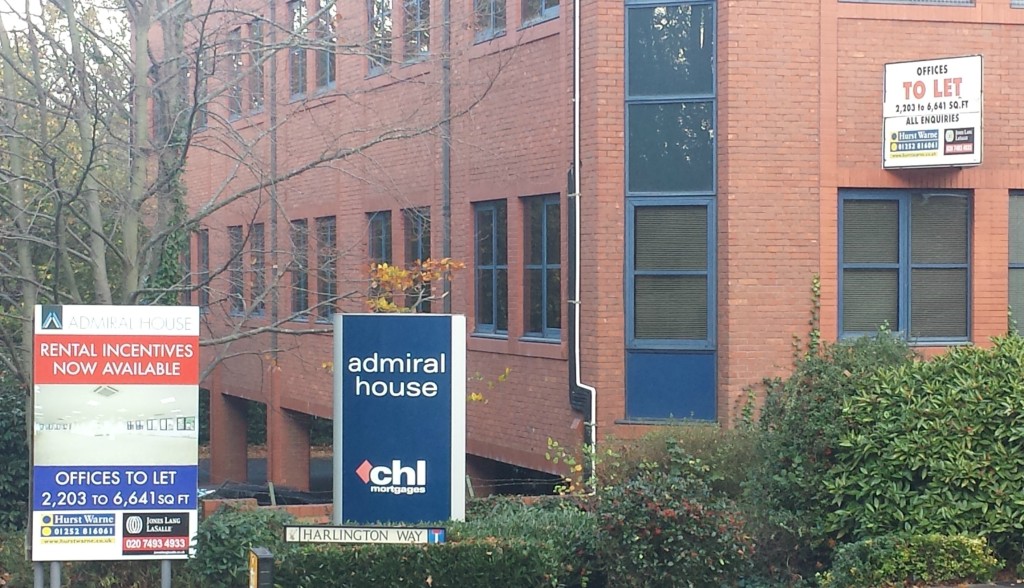
We Heart Hart’s mascot, Bravehart

As has become the style of Parliamentary questions, I have been posed a question by Steve of Fleet West.  It’s a long and complicated question, but I will do my best to answer it.

The question put to me was:

Question for you. Because Hart already has more SHLAA sites than needed, the duty to cooperate under the localism act required us to use them to deliver neighbouring districts excess needs regardless of whether a new settlement is selected as an option. Some of the SHLAA sites used would inevitably be those in And around Winchfield, but without the master planning and infrastructure provision possible with a planned settlement. And many would be urban extensions causing a burden on existing towns causing further local issues. Do you not think this is the case, and if so why?

First, my understanding is that the “duty to cooperate” is not a “duty to agree” (as we were told by Peter Village QC) and Hart should be robust on two fronts:

  • They should challenge the alleged “need” in the SHMA.  We’ve already established it is based on out of date population forecasts and calls for an “aspirational” level of employment growth that is simply unrealistic.  If these arguments are taken on board, the whole issue of having t meet the needs of neighbouring districts falls away.
  • Hart DC should be robustly challenging Rushmoor in particular who could build more by increasing the density at Wellesley and by releasing some or all of the 96 Ha of employment land they are protecting that it not needed to meet even the inflated employment forecasts.  Rushmoor could even meet some of Surrey Heath’s unmet need.

Second, with or without a new settlement, I simply do not believe the infrastructure numbers add up, and I believe we are being sold a pig in a poke.  £300m costs, versus £50m of developer contribution against an existing £78m infrastructure funding black hole.

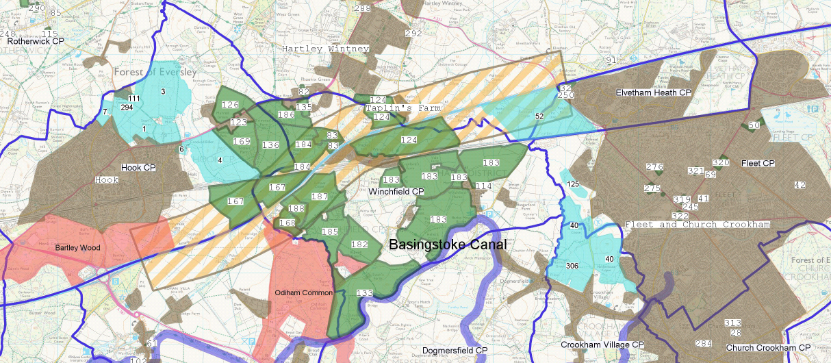
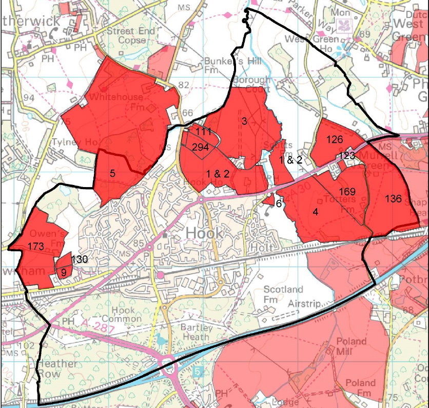
Third, it is extremely unlikely that individual Winchfield sites will be picked off (outside those recommended in the Winchfield Neighbourhood Plan) because they simply do not meet the criteria as suitable places for development.  Let’s run through some of the constraints identified in the official evidence base:

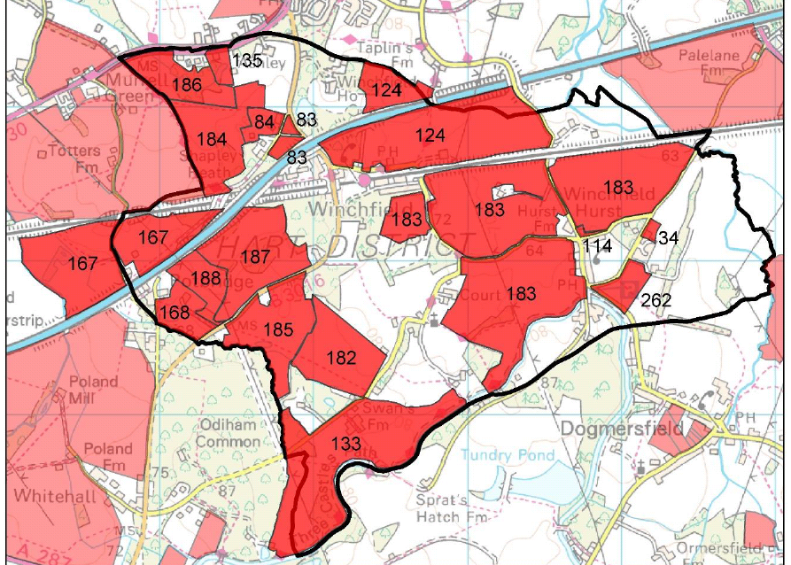
SHL 83: The area of the site which is a SINC should not be developed and should be protected from any development, as should those other SINCs nearby. A contribution towards SPA mitigation would be required. Policy would need to be changed for this development to be permitted by way of allocating a settlement boundary to Winchfield which includes this site (however this seems unlikely given that the site is on the other side of the M3 from the rest of Winchfield. The constraint relating to the location, remote from settlements with a boundary seems unlikely to be overcome therefore the site may not be considered suitable or achievable in future.

SHL 133: The fact that the site does not relate to any existing settlement boundary cannot be overcome. Policy would need to be changed for development to be permitted at this location by way of a broader strategic allocation.

SHL182: Site is not related to any settlement; Southern boundary edge within flood zones 2 and 3. Mostly high, but partly medium potential likelihood of groundwater flooding.

SHL183: Site is not related to any settlement; North eastern corner in flood zone 2 and 3; High potential likelihood of groundwater flooding.

SHL184: Site is not related to any settlement; Mostly medium, but some high potential likelihood of surface water flooding.

And then of course we have the Adams Hendry assessment of the combined strategic site:

  • “The road infrastructure in the Winchfield area reflects the areas rural character and has limited capacity for additional traffic. Therefore a key infrastructure issue for developing any significant level of housing at Winchfield is how the road infrastructure can be upgraded to meet the projected levels of demand and how traffic to/from the new development would access the M3 Motorway.”
  • “There are a number of significant nature conservation features and designations either adjacent or in close proximity to the site.
  • “Some part of the site are subject to area based TPOs, particularly to the north of the site, near to Winchfield House”.
  • “The Hampshire Minerals and Waste Plan Policies Map indicates that parts of the site contain areas subject to minerals safeguarding for sharp sand and gravel… The extent to which this might constrain development will need to be assessed, including through engagement with Hampshire County Council.”
  • “The two halves of the site differ in landscape terms with the western half being characterised by the mosaic pattern of generally medium-sized fields interspersed by numerous wooded copses and heavily wooded field boundaries… Most of this part of the site could reasonable be characterised as attractive rolling countryside… The potential for new development within this area to negatively impact on landscape character is considered to be significant.”
  • “The eastern half of the site is much more open, except for the southern portion near to the Basingstoke Canal… The countryside in this area is less attractive than the western part of the site, although its lack of current development and open nature means that significant development in this area has the potential to cause considerable harm to landscape character.
  • “It is possible that the site contains some ʻbest and most versatileʼ (BMV) agricultural land, but this would need to be confirmed through a survey.”
  • “There are a variety of Listed Buildings within and adjacent to the site… The most significant heritage features impacting on the site are as follows:-
    • The Basingstoke Canal Conservation Area… there is considered to be a risk that development towards the south of the site will negatively impact on the setting of the Canal;
    • Dogmersfield Park (Historic Park and Garden)
    • Winchfield House (Grade II*) and its extensive grounds
    • St Mary’s Winchfield if a Listed Norman Church (Grade I)… it is considered that development close to the southeast boundary could have a negative impact on the currently very rural and sparsely developed setting of the church.”
  • “Significant parts of the site are subject to the risk of groundwater flooding at the surface”.
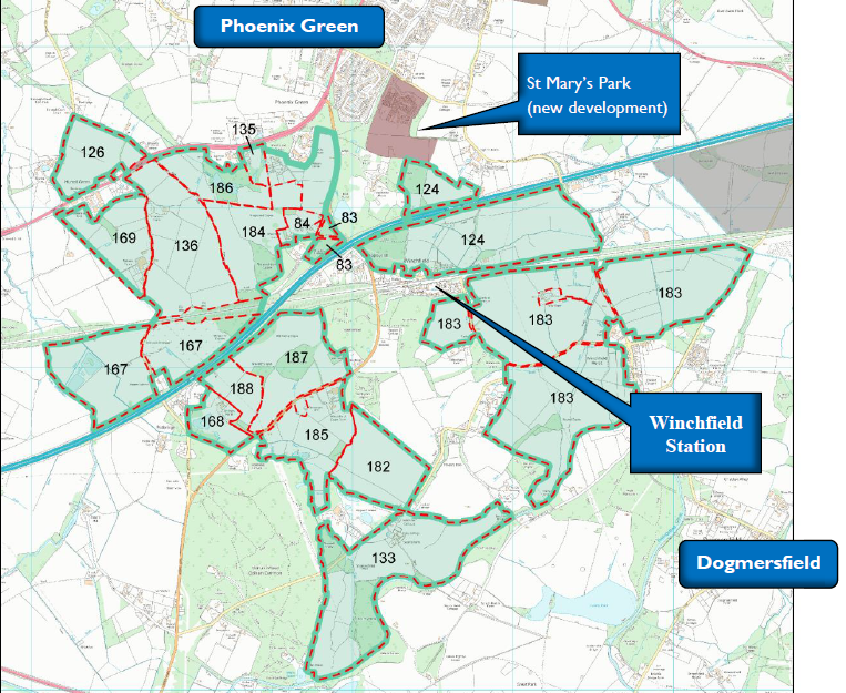
  • “The nature of the site, split, with substantial areas of farmland, as well as Winchfield Station between the two halves is considered to significantly influence how a new settlement could be planned. It would be challenging to plan a compact nuclear settlement on this site and the shape of the site lends itself more to a linear or ʻlinked polycentricʼ approach.”
  • “Development at the north of the site risks leading to settlement coalescence with Hartley Wintney”.
  • Overhead power lines traverse the site and may represent a constraint”.
  • “The extent to which environmental noise from the motorway and railway impacts on the site should be ascertained”.

So, it seems that Winchfield is a bad location for a new settlement, and an even worse location for individual developments.  I would hope we can avoid urban extensions on green fields too, and would like to see significant regeneration of existing towns and investment in infrastructure in those places.


Would a new town be safe for our children?

500m M3 exclusion zone near Winchfield Hampshire

Proposed new town in Winchfield and Hook, Hampshire with 500m exclusion zone around the M3

Many councillors are doing their utmost to promote the supposed benefits of a new town – Hartley Winchook, but it is clear that the plans have not been properly thought through.  For instance, what is the impact on  the health and well-being of our children?

First let’s take a look at site of the proposed new town in the image above or on this link.

As can be clearly seen the M3 and the railway go straight through the middle of the proposed sites.  However, a number of medical studies have been carried out in a number of countries such as the US, Germany and Holland that highlight the dangers to children’s health of living close to major highways such as motorways.  Examples can be found here, here and here. The highlighted risks include cardiac and pulmonary risks, wheeziness in children, shorter lifespans, premature births, asthma and cancer.  It is worth noting that a new school is proposed just north of site 83 on the map above, meaning the children living in the new town would both live and go to school very close to the motorway.  In the light of these studies, Councillor Dr. Anne Crampton has proposed that there should be a 500m exclusion zone for new housing around the M3 (shown in yellow hatching on the map).  The implication of this, as can be seen from the map, is that many of the proposed sites would be rendered unsuitable if Dr. Crampton’s proposal was adopted and in fact, the whole new town proposal would fail.  So, it seems we have  choice: protect our children or concrete over the green fields.

There’s another issue too.  The proposed site of the secondary school is between the motorway and the Mildmay Oaks hospital that was housing child sex offenders (one of whom escaped) and other patients who were violent towards staff. Originally, this school site was proposed in the Barratts Vision document that some councillors have since  disowned. But, amazingly, this location is still proposed for the secondary school in the site assessments from Hart District Council (HDC) – see image from this document below – Mildmay Oaks is inside the pink blob towards the middle of the image and the boundary for the school is shown in blue.

Potential school next to MIldmay Oaks Hospital Winchfield Hampshire

Potential school next to Mildmay Oaks Hospital Winchfield Hampshire

It is clear that this new town proposal has not been well thought through at all and if this is no longer the proposed site for a school, then the council should say where the school would go.  Would it be within the proposed 500m exclusion zone?

It is worth noting also, that if this 500m exclusion zone were applied, it would also reduce the brownfield capacity at Ancells Farm, so we would have to seek out some additional sites and the urban extension at Pale Lane would also be deemed an unsuitable site.

We have created a dedicated consultation page and two guides to responding to the consultation that are available on the downloads below. The comments are designed to be cut and pasted into the boxes provided.  It will be very powerful if you could edit the comments into your own words. Please do find time to respond to the consultation and play your part in saving our countryside.

Full version:

Responses to Local Plan Consultation

2 Minute version:

Respond to Local Plan Consultation in 2 minutes

How developers have gained a stranglehold over Local Plans

The latest 2012-based government projections of population and the number of households points to a need of around 215,000 dwellings per annum, compared to recent delivery of around 150,000 new dwellings each year. It is clear we need to respond to the objective in the National Planning Policy framework to “boost significantly the supply of housing”. To achieve this, it follows that the sum of all the housing market assessments across the country should add up to the total expected increase in households, or a little more to give some margin of safety.

However, there is increasing evidence that housebuilders have too strong an influence over the process that is leading to housing market assessments being artificially inflated to a level much higher than that required by the national household projections.

By way of example, in Hart, the only consultees outside of the council in the work to produce the Strategic Housing Market Assessment (SHMA) were housebuilders, their representatives and registered providers. The resulting objectively assessed “need” was nearly 50% above the starting point identified by the DCLG’s 2011-based population projections. A series of adjustments were made to the raw forecasts to take account of inward migration to the area, average household size and a near doubling of the historic job creation rate. Many of these adjustments have been shown to be erroneous by the release of the DCLG 2012-based population forecasts that are much lower than those identified in the needs assessment.

The experience of the Hart, Surrey Heath and Rushmoor SHMA is by no means unique. Analysis of five other housing needs assessments of planning authorities across Hampshire, Oxfordshire, Surrey and Berkshire reveals an average housing uplift on the baseline population projections of around 42%.

If this were applied across the whole country, then we would be allocating land and allowing the building of some 305,000 new dwellings each year, far above the national requirement. This goes against latest planning guidance that states that housing need should be “principally understood as a measure of future demand rather than aspiration”. An FOI request has been made to the DCLG to provide the national figures, but this has been refused on the grounds that DCLG “does not hold this information”. Given the importance that is being placed on housing delivery, it is quite staggering that central Government is not monitoring the results of housing needs assessments on a national basis.

As a group of local residents, we looked at the housing needs assessment for Hart and came to the conclusion that many of adjustments and the resulting “need” were inappropriate and challenged the Council. But, as we were lay people and not planning “experts” our views fell on deaf ears. So, we decided to seek the opinion of professional planning consultants to provide an independent challenge to the objectively assessed need. Our experience indicates that many planning consultants are reluctant to get involved in challenging these assessments because they get most of their work from developers and do not wish to bite the hand that feeds them. We approached a number of planning consultants and they either did not reply to us, were conflicted or said they normally act for developers and would be unable to help. Eventually, we found Alan Wenban-Smith.

Once a Local Plan gets to the stage of being examined by the Planning Inspector, the situation gets worse. Because housing needs assessments are usually produced for a combination of planning authorities but Local Plans are examined at the planning authority level, the actual housing need numbers are effectively unchallengeable. The examination focuses on the process for arriving at the housing need and the actual content is immune from challenge. Residents and environmental interests are being crowded out of inspections by the expensive hordes of lawyers, agents and consultants hired by builders and landowners who share an interest in a narrow discussion focused on achieving the maximum possible increase in estimated housing needs.

In effect, the whole process of assessing housing need through to inspecting the resulting Local Plans has been hijacked by the development industry and their narrow interests. This is in direct contravention of the NPPF which states that local people should be empowered to shape their surroundings, with succinct local and neighbourhood plans setting out a positive vision for the future of their area.

The consequence of this is that local planning authorities are being bounced into allocating green field sites for development because they are easier to develop than brownfield sites. This will result in an over-supply of land and lead to land-banking by the developers, who will only build at a rate consistent with maximising their profits. If they supplied new housing at a rate that meant house prices fell, they would immediately reduce output because their business model and in particular the price they pay for land is predicated on steadily increasing house prices. So, in effect we are being asked to allocate too much of our most valuable green field land for housing, but will not actually increase the supply of housing to meet the needs of our neighbourhoods and we leave acres of vacant and derelict brownfield sites.

We need to take action now to remove the stranglehold of developers have on this process, put more power back in the hands of local people and take further measures to mandate the development of brownfield sites and protect our countryside. This might involve increasing the powers of local authorities to compulsorily purchase derelict sites and use the profits to invest in our creaking infrastructure.

We must stiffen the resolve of our local representatives to resist the self-interest of developers and work instead for their electorate.  We must also stand up and fight for brownfield only development to protect our countryside from urbanisation. We must vote against a new town.

We have created a dedicated consultation page and two guides to responding to the consultation that are available on the downloads below. The comments are designed to be cut and pasted into the boxes provided.  It will be very powerful if you could edit the comments into your own words. Please do find time to respond to the consultation and play your part in saving our countryside.

Full version:

Responses to Local Plan Consultation

2 Minute version:

Respond to Local Plan Consultation in 2 minutes


Impact of a new town on Fleet and Church Crookham

Fleet and Church Crookham

Impact of new town on Fleet and Church Crookham

I have a great deal of sympathy for residents of Fleet and Church Crookham who have suffered a great deal of development in recent years with insufficient investment in infrastructure.  However, a new town in Winchfield, Hook and Hartley Wintney parishes is not the panacea for Fleet residents that that many of the Hart Councillors would have you believe.
There will be negative impacts in 4 main ways:

  • Starvation of infrastructure funding
  • Extra traffic and congestion
  • Lack of affordable homes
  • Destruction of amenity space

Infrastructure Funding

Hart Council currently has a £78m infrastructure funding deficit, much of it in Fleet, Church Crookham and Hook. This does not include healthcare where there is a forecast £47m funding deficit in five years time.  A new town will need about £300m of infrastructure spending to make it work, but a realistic assessment of developer contributions is £40-50m.  This leaves a further gap of ~£250m.  There are already complaints about long waiting lists at doctors and lack of other amenities.  It is clear that a new town will be under-funded with consequent impact on other parts of Hart District, where there will be no spare money to address the deficit that already exists in all areas of Hart including Fleet and Church Crookham.


Congestion

Where Hart Residents Work

Where Hart Residents Work, SHMA Figure 13

Let’s have a look at where Hart residents work, using the evidence of the Strategic Housing Market Assessment (SHMA).

A bit less than half of them work in Hart – 45%. So of the 12,500 new people in a new town, 45% of those of working age will work in Hart. The biggest employment centres are in Fleet and Hook. So a significant proportion of the new town workers will go to work in Fleet. They are not all going to work in a new supermarket in the new town.

A significant proportion will also work in Rushmoor (Farnborough and Aldershot), Surrey Heath (Camberley) and Waverley (Farnham) – some 18% in total.

The most obvious travel to work route for many of these people will be along Pale Lane, through Elvetham Heath/Fleet or along Chatter Alley, through Dogmersfield, Crookham Village and Church Crookham.  But these roads are narrow and a difficult to upgrade due to bridge constraints, so maybe a new road out of the new town on to Hitches Lane will be required.

A big portion – 6.2%, will use the train to go up to London from a station that is already full, on a line that is operating at or above design capacity.

Another group will go to Hook directly, or through Hook and/or Hartley Wintney to get to Reading or Bracknell adding to existing peak time congestion on the A30.

Pretending a new town will have no impact on congestion in Fleet and the Crookhams is plainly wrong.

Surely much better and more sustainable to direct housing development to the east of Fleet at Ancells Farm, Bramshott Farm and Pyestock (some of them brownfield sites) with a cycle route to Fleet station and a cycle route to the Cody Tech centre or the Farnborough airport complex.

Affordable Housing


Vacant Office Admiral House, Harlington Way, Fleet, Hart District, Hampshire

Admiral House, Harlington Way, Fleet, Hart District, Hampshire

As of 26/11/15, the cheapest 1-bed and 2-bed new homes available within 1 mile of Fleet are available at prices of £215,000 and £235,000 (Rightmove). Median household incomes for Hart are £40,200 per Figure 4.8 of the SHMA. This means that the cheapest new homes are between 5.3 and 5.8 times median incomes and out of reach for the average household, so something should be done.

The SHMA calls for 60-70% of new build to be 1 and 2-bed properties across the Housing Market Area.  The developers are going to want to do what they always do, that is to build 3-5 bedroom detached houses in the new town which will be no doubt attractive to those moving from London, but will do nothing to meet the needs of ordinary people living in Hart.

Surely, it would be better to build smaller, starter properties on brownfield sites such as Ancells Farm, Fleet Road, Harlington Way in Fleet and Bartley Wood in Hook to give younger people a more affordable first step on the housing ladder.  This iwll do far more to meet the actual need outlined in the SHMA, and be more sustainable for our environment.

Destruction of amenity space

The Heart of Hart, the area around Winchfield, is used as an amenity area for walking, cycling, watching wildlife and other recreation. Concreting it over and joining together Hartley Wintney, Winchfield and Hook into a giant Hartley Winchook conurbation will lead to lack of amenity for everyone.  Hart Council is yet to report on the consultation it ran earlier this year on how we value our amenity space.

If you are concerned about the impact of a new town, we have created two guides to responding to the consultation that are available on the downloads below. The comments are designed to be cut and pasted into the boxes provided.  It will be very powerful if you could edit the comments into your own words. Please do find time to respond to the consultation and play your part in saving our countryside.

Full version:

Responses to Local Plan Consultation

2-minute version:

Respond to Local Plan Consultation in 2 minutes

New town plan transforms Winchfield into a concrete jungle

Winchfield SHLAA Sites in Hart District Hampshire

Winchfield SHLAA Sites in Hart District Hampshire

The combination of the sites put forward for the Winchfield new town will put more than half of the beautiful countryside at the Heart of Hart under concrete with devastating impacts on the ecology and environment.  But readers should also note that around a quarter of the planned houses will be in Hook parish, with some of it in Hartley Wintney next to the Dilly Lane development, many houses on the boundary with Odiham Parish and of course the eastern boundary of the site will directly abut Fleet and be very close to the Edenbrook estate.

The notion that this is in any way “sustainable development” is total nonsense and the notion that there will be limited impact on other areas of the district is also nonsense.

If you want to protect our countryside you must vote for Approach 1, a dispersal strategy in the Local Plan consultation and ask Hart Council to find again the 1,400 sites they lost.  Our remaining needs can be met from brownfield sites alone.

We have created a dedicated consultation page and two guides to responding to the consultation that are available on the downloads below. The comments are designed to be cut and pasted into the boxes provided.  It will be very powerful if you could edit the comments into your own words. Please do find time to respond to the consultation and play your part in saving our countryside.

Full version:

Responses to Local Plan Consultation

2 Minute version:

Respond to Local Plan Consultation in 2 minutes

Do we really want to create a giant Hartley Winchook conurbation?

Winchfield and Hook New Town proposal

Hartley Winchook New Town proposal for Hart District in Hampshire

As you may know, Hart District Council has embarked on a new consultation about the Hart Local Plan.  One of the approaches put forward is for a “new settlement at Winchfield”.  However, this is misleading because a number of the sites that form part of the proposal are in the Hook and Hartley Wintney parishes.  This new town proposal is really a plan to create a single conurbation of Hartley Winchook that will damage the distinct identity if each of the existing settlements.

Moreover, there are also sites in the Strategic Housing Land Availability Assessment that further encroach on the parishes of Hartley Wintney and Hook.

Let’s take a look at Hartley Wintney parish first:

Hartley Wintney SHLAA sites in Hart District

Hartley Wintney SHLAA sites in Hart District, Hampshire

As can be seen, many of the proposed new town sites adjoin the Hartley Wintney parish boundary and site SHL 124 actually adjoins what will become phase 2 of the St Mary’s Park Dilly Lane development.  Moreover, the pink rectangle that is bisected by the Hart Parish boundary where it adjoins Fleet and Elvetham Heath is the site of a proposed urban extension to the Elvetham Heath community.

Now, let’s take a look at Hook:

Hook SHLAA sites in Hart District

Hook SHLAA sites in Hart District, Hampshire

As you can see, sites 126, 136 and 169 already make up part of the proposed new town and they are in the Hook Parish and 1,458 houses are proposed.  More than half of SHL167 is also in Hook Parish, delivering a further 400 houses to Hook, giving a total of around 1,850 dwellings.  These are very close to sites 1&2 where Hart Council has already resolved to grant planning permission and to sites SHL 3 & 4, which so far have been rejected, but the capacity is between 1,000 and 2,800 houses.  It is surely only a matter of time before voracious developers start to lobby for sites 3 and 4 to be included in the package to make the whole thing “more sustainable”, as if concreting over our green fields is in any way sustainable.

The only way to combat this urbanisation of our countryside is to vote for Approach 1, dispersal in the current consultation about the Hart Local Plan, and make comments saying you want Hart Council to find again the brownfield sites they said were “readily quantifiable”.

We have created a dedicated consultation page and two guides to responding to the consultation that are available on the downloads below. The comments are designed to be cut and pasted into the boxes provided.  It will be very powerful if you could edit the comments into your own words. Please do find time to respond to the consultation and play your part in saving our countryside.

Full version:

Responses to Local Plan Consultation

2 Minute version:

Respond to Local Plan Consultation in 2 minutes

Suggested Responses to prioritise brownfield sites in the Hart Housing Options Consultation

Vacant Office Flagship House, Fleet, Hart District, Hampshire

Vacant Office Flagship House, Fleet, Hart District, Hampshire

I know it is coming up to Christmas, and no doubt, like me, you have better things to be doing with your time.  But Hart District Council has published a new consultation on Housing Options that is open until January 15 2016 and we must respond to it.

We have created a dedicated page about this consultation here, and below we have put forward some suggestions on how to respond to the consultation.  We apologise in advance for the length of our document, but the consultation is a bit long and quite complex so we wanted our response to be as comprehensive as possible.

The consultation is available here, and our suggested responses available on the download below are set out in the order they appear on the online form. We give guidance on how to respond to the ranking questions and suggested comments to make. The comments are designed to be cut and pasted into the boxes provided.  It will be very powerful if you could edit the comments into your own words.  Please do find time to respond to the consultation and asking Hart to find the 1,400 units they “lost” on brownfield sites.

We have created two guides to responding to the consultation that are available on the downloads below. The comments are designed to be cut and pasted into the boxes provided.  It will be very powerful if you could edit the comments into your own words. Please do find time to respond to the consultation and play your part in saving our countryside.

Full version:

Responses to Local Plan Consultation

2 Minute version:

Respond to Local Plan Consultation in 2 minutes


Hart Council doesn’t know how it decided we had 1,800 brownfield sites

Let's just make up the brownfield numbers

Hart Council admits it made up the numbers

Hart District Council has said that it doesn’t have any back-up to the claim it made in Hart News and at Cabinet that we had capacity for 1,800 dwellings on brownfield land.  The implication of this is that it simply made up the numbers, which calls into question whether we can believe any of the numbers the council publishes about the Local Plan.

[update] On September 3, the council said the following in Cabinet papers:

“Active engagement has occurred with local commercial agents to encourage them to inform their clients that residential conversion or redevelopment is a realistic option. This action has undoubtedly increased interest in the potential availability of residential conversion. In this regard it is the Council can reasonably increase potential Local Plan delivery from brownfield sites to over 1,800 dwellings which at this stage can be readily quantified.”

[/update]

Hart also published its estimate in Hart News, see below:

Why we need 3,500 new homes in Hart

Why we need 3,500 new homes in Hart

We asked:

Please provide an analysis, including SHLAA ref, site name and description, site area in hectares, and expected yield, of the sites that have been used to build up the estimate provided at cabinet on 1 October 2015, when it was asserted that the ‘guesstimated’ capacity for brownfield development in the district up to 2031 was now 1,800 dwellings (up from the 750 dwelling estimate of a year ago and compared to the 2,438 units estimated by WeHeartHart).

How will the recent Government announcement extending permitted development rights indefinitely and allowing automatic planning permission in principle on brownfield sites impact your assessment of brownfield capacity?

Hart has now replied to our FOI request saying:

With regards to the first request, we do not hold that information. The paper on Brownfield Land that went to Cabinet on 3rd September 2015 is available here

With regards to the second request, FOI relates to recorded information held by the Council and not to matters of opinion. We do not hold the information you seek.

We have asked for an internal review of this decision because Hart have apparently lost 1,400 of these homes since September.

There is a brownfield solution to Hart’s housing needs

Vacant brownfield Block at Ancells Farm, Fleet, Hart District, Hampshire

Vacant Office at Ancells Farm, Fleet, Hampshire

We have done some further analysis on Hart’s Strategic Housing Land Availability Assessment (SHLAA) and come to the conclusion that Hart’s housing needs can be met from brownfield sites alone.  We believe this is a potentially viable solution that should form part of the forthcoming Housing Options consultation as part of the Local Plan.  Instead Hart Council have ignored the wishes of 2,130 people who signed the WeHeartHart petition and only put forward solutions that involve concreting over vast swathes of our countryside.

Created using the Donation Thermometer plugin https://wordpress.org/plugins/donation-thermometer/.2,350Hart District Brownfield Development Target3,993Hart District Brownfield Development Target170%

[Updated 2 March 2016 to add in the new brownfield SHLAA sites as described here]

[Updated 31 March 2016 to include Pyestock (aka Hartland Park)]

[Updated 30 August 2016 to re-set target to 2,350 now that Moulsham Lane, Yateley has been given the go ahead]

So, how have we arrived at our conclusion?

Brownfield sites in the SHLAA

We have been through the SHLAA and identified those sites that are mostly or wholly brownfield in nature, and added up total capacity as recorded in the SHLAA.  Pyestock (aka Hartland Park), is now also an official SHLAA site.  In total, these sites amount to between 3,208 and 3,250 homes at an average density of a relatively modest 28 dwellings per hectare (dph). The detail is shown in the table below:

ParishRef.NameBrownfield Capacity in Table 1 in DLPSite Assessment Capacity (Low)Site Assessment Capacity (High)Size (Ha.)Low Density (dpa)
Blackwater and HawleySHL21Linkwater Cottages, Blackwater12120.6418.75
Blackwater and HawleySHL100Sun Park, Guillemont Park North3003203201226.66
BramshillSHL106Bramshill (Police Training Centre)2502501025
Church CrookhamSHL2826/32 Bowenhurst Road8660.4214.28
Crookham VillageSHL158Crondall House, Fleet27271.1323.89
DogmersfieldSHL39Fermoy, Farnham Road5102.232.24
DogmersfieldSHL55Land at Church Lane, Dogmersfield20200.8224.39
Elvetham HeathSHL104Land at Elvetham Heath4545452.2520
EversleySHL127Land at Paul’s Field, Eversley70702.825
EversleySHL140Land off Warbrook Lane53531.7630.11
EwshotSHL36Dachs Lodge, Redfields, Church Crookham29291.224.16
EwshotSHL80Tanglewood, Ewshot770.3122.58
EwshotSHL174Peacocks Nursery Garden Centre1051053.530
EwshotSHL235Land at Willow Croft, Church Crookham50502.7518.18
FleetSHL41Imac Systems, Fleet6660.05120
FleetSHL42Camden Walk, Fleet9880.2433.33
FleetSHL50Waterfront Business Park, Fleet60601.4641.09
FleetSHL6918 Church Road, Fleet10100.07142.85
FleetSHL102Land at Bramshot Lane45451.825
FleetSHL113Thurlston House1712120.6817.64
FleetSHL245Land at 154-158 Albert Street & Fleet Road14880.1844.44
FleetSHL275Land at Little Mead, Fleet12171.0611.32
FleetSHL320Fleet Town Centre Zone 2201501501.883.33
FleetSHL322Fleet Town Centre Police Station1737370.6160.65
FleetSHL357Land at Sankey Lane, Fleet20200.6431.25
FleetTBAPyestock (aka Hartland Park)1,5001,50048.238.1
Hartley WintneySHL95Nero Brewery, Hartley Wintney660.1540
Hartley WintneySHL216Land adj. to James Farm Cottages, Hartley
Wintney
660.2920.68
HookSHL111Hook Garden Centre, Reading Road, Nr. Hook57574.4712.75
Long SuttonSHL296Old Dairy, Long Sutton550.225
OdihamSHL29Land at Butts End660.415
OdihamSHL66Rear garden of 4 Western Lane, Odiham16160.6425
OdihamSHL119Land at the rear of Longwood, Odiham990.3129.03
South WarnboroughSHL70Stables at Lees Cottage, South
Warnborough
550.2520
South WarnboroughSHL172Granary Court, South Warnborough16160.6923.18
WinchfieldSHL34Land adjoining Winchfield Court18251.0616.98
WinchfieldSHL84Land at Winchfield Lodge60603.815.78
WinchfieldSHL114Trimmers Cottage, Winchfield Hurst12120.4924.48
Church CrookhamSHL81Vertu, Beacon Hill Road, Church Crookham65701.7636.93
Blackwater and HawleySHL176Hawley House, Hawley8100.326.66
CrondallSHL178Broden Stables & Stable Yard, Crondall14271.410
CrondallSHL179Bowenhurst Lane, Crondall30351.520
Hartley WintneySHL189Land at James Farm, Hartley Wintney880.3125.8
Total3,2083,25011727.9

A number of these sites are “not currently developable” according to Hart.  But most of the green field sites they have put forward are also not currently developable.  We believe that the issues surrounding brownfield sites should capable of being resolved more easily than those for green field sites.

Sites not in the SHLAA

There are a number of sites not in the SHLAA that nevertheless should be considered that amount to around 785 additional homes.  These include the parts of Ancells Farm, Bartley Wood and Fleet High Street that have not already been permitted or counted elsewhere. We have also counted the complex of under-utilised offices that include Admiral House, Flagship House, Hart Offices and Harlington centre in Fleet.  Much of this site was recommended by Fleet Future, but for some reason Hart Council have ignored it.  But we can think of no reason why a council that was truly committed to a brownfield first strategy would not offer up its own under-utilised offices to be part of new, mixed use development and move to one of the other vacant office blocks in the district.  These sites, with an allowance for parts of sites that have already been permitted, are shown in the table below.

ParishSite DescriptionEstimated capacityNote
FleetAdmiral House, Flagship House, Hart Offices and Harlington centre350Paper by Gareth Price identified 775 units on a larger site incorporating much of this area
FleetAncells Farm370From Stonegate report
FleetFleet vacant offices220From Stonegate report
HookBartley Wood200From Stonegate report
Less units already granted permission or already counted-355Part of Ancells Farm and Barley Wood already granted. SHL 320 already counted
Total785

Conclusions

Drawing this together, there’s capacity for between 3,993 and 4,035 units on brownfield sites, without increasing the density on any of the SHLAA sites.

Now, according to Hart, we have to find space for a further 2,350 homes (now that 150 houses have been approved at Moulsham Lane, Yateley), according to the current Strategic Housing Market Assessment (SHMA).  This shows that we have now more than met our remaining needs from brownfield sites alone. We certainly do not need a new town at Winchfield or any new urban extensions in Hook, Fleet or Elvetham Heath.

However, we also know that Alan Wenban-Smith has challenged the SHMA and said that we need around 2,000 fewer houses.  If this were accepted by the inspector, we would have an even bigger surplus of brownfield capacity to take into the next planning period.

We also know that the SHMA is being revised, and the Government has published revised population and household forecasts earlier this year and these showed much lower figures for Hart.  Again, this should result in a lower housing allocation, and we would end up with a surplus of brownfield sites until the next planning period.

This begs the question why Hart Council is not including a formal brownfield option in its forthcoming consultation, when that was the clear view of the 2,130 people who signed the WeHeartHart petition.  Persisting with new town and urban extension solutions is untenable.  Please do get involved with this consultation and respond to it using our guide on our dedicated page about this consultation here.

Hart Council’s new consultation still likely to leave it in a hopeless position

It seems likely that Hart Council is about to launch a new consultation on housing options for the district as part of the Local Plan.  We are following this closely, and will publish some additional materials to help residents make up their mind once the full consultation has been made public.

But having reviewed the materials already on Hart’s website (cabinet meeting materials for 18 November 2015), it seems clear that the council have taken no notice of the legal opinion they received from top QC Peter Village, that described their position as “hopeless”.

That opinion said:

…there is no evidence that to date there has been any consideration by the Council of the “reasonable alternative[s]” of providing less than the OAN, on environmental grounds…

There has been no regulation 18 consultation at all on issues such as employment, retail, transport, infrastructure (or, indeed, anything other than housing distribution). It is inconceivable that a coherent and sound local plan could emerge without addressing most (at least) of these issues. Thus, the Council presently appears to be in a hopeless position if it maintains its current course. Either it will proceed with a plan that does not address fundamental matters (thereby exposing itself on the “soundness” issue), or it will incorporate matters which have indisputably not been the topic of any regulation 18 consultation.

We have been through the consultation materials in some detail, and we can find no reference to the council considering providing fewer houses on environmental grounds, and no sign of consulting us residents on employment, retail, transport or infrastructure.

Coupled with the issues we raised to the council on Friday, it is looking like this consultation is going to be an expensive waste of time and taxpayers’ money because we are still not being offered a proper consultation on all the issues that matter. Please do get involved with this consultation and respond to it using our guide on our dedicated page about this consultation here.