Hart Local Plan and planning application update

Hart Local Plan and planning application update

There is a great deal of activity behind the scenes about the Hart Local Plan. The timetable for delivery is becoming clearer and there are updates on a number of planning applications that will shape the future of our district.

Hart Local Plan Timetable

We Heart Hart understands the upcoming timetable for the Hart Local Plan is as follows:

During w/c 28 November: The new Strategic Housing Market Assessment (SHMA) will be sent to councillors.

29 November 2016: Local Plan Steering Group (LPSG) Meeting, where we understand the timetable for the Hart Local Plan will be discussed and drafts of new Planning Policies will be considered.

December 13 2016: A further LPSG meeting will be held to review the draft spatial strategy. This will set out the number of houses we need to build and suggest where they will be built.

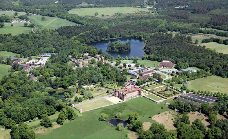
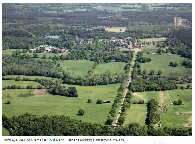
December 14 2016: We understand that the planning application for 423 houses at Grove Farm (aka Netherhouse Copse) near Crookham Village to the west of Fleet, will be considered at the Planning Committee. It is possible that some of the applications to redevelop the former Police College at Bramshill House will be considered.

January 26 2017: Draft Local Plan to go to full Council.

Upcoming Planning Applications

The long standing application for around 550 houses to the North East of Hook was finally signed off on 21 November.

The application for 423 houses at Grove Farm (aka Nether House Copse), near Crookham Village will be considered at the Planning Meeting on December 14. More details of this application can be found here and searching for application reference 16/01651/OUT.

It is possible that some of the applications for redevelopment of the former Police College at Bramshill House will be considered. There are a number of applications outstanding on this site that can be found here. The main applications appear to be 16/00726/FUL for 235 units and 16/00721/LBC for 25 units. At least this is a brownfield site, although controversial, being so close to the Thames Valley Heath SPA.

This week, Wates submitted an outline planning permission for 700 dwellings at Pale Lane (also known as Elvetham Chase). More details of this application can be found here and searching for application reference 16/03129/OUT

Conclusions

We don’t yet know how HDC are going to treat these applications, or if they have other ideas for strategic locations for additional housing. Of course, we await an application to redevelop the brownfield site at Pyestock (Hartland Village) and of course Winchfield has been mooted as a site for a new town, but we believe this has failed testing. Other strategic sites that were being considered include Murrell Green (between Hook and Hartley Wintney), Lodge Farm and West of Hook. Of course proposals are also being developed for the so called Rye Common New Village.

It is galling to say the least that we are seeing so many applications on greenfield sites instead of brownfield sites. It is imperative Hart produces the new Hart Local Plan and the new Planning Policies ASAP. This will allow us to regain control over where houses are built in the district.


Hart’s Brownfield Register fails to meet expectations


Brownfield site: vacant offices at Ancells Farm Business Park, Fleet, Hart District, Hampshire.

Brownfield site: vacant offices at Ancells Farm Business Park, Fleet, Hart District, Hampshire.

Hart District Council has at last published its register of brownfield sites in the district. Sadly, the register has failed to live up to expectations. The full register can be downloaded on the link below.

The purpose of the brownfield register is to provide house builders with up-to-date and publicly available information on all brownfield sites available for housing locally. The register is supposed to help housebuilders identify suitable sites quickly, speeding up the construction of new homes. Hart Council was one of the pilot local authorities participating in the national brownfield register scheme as announced back in March 2016.

At first glance, the register identifies 3,542 potential units on brownfield sites, which might be considered good news.  However, closer inspection of the register reveals:

  • All but two of the sites already have planning permission, indeed a number of them have already been built (e.g. Queen Elizabeth Barracks at Church Crookham, Landata House in Hook, and Monachus House in Hartley Wintney).
  • Some of the sites are not even brownfield sites, for example Rifle Range Farm in Hartley Wintney.
  • None of the sites that Hart Council itself identified as brownfield sites in the recent consultation are recorded in the register.
  • None of the other potential sites that have not yet been permitted on Ancells Farm or along Fleet Road have made it on to the register.
  • Very few, if any, of the brownfield sites in the SHLAA that we identified in our brownfield solution, most particularly sites like the former police college at Bramshill have made it into the register.
  • Over 2,000 of the units in the register have already been granted planning permission, with 1,500 units at Hartland Village (aka Pyestock) and 16 at another site yet to be granted permission.

We have contacted the council to find out the reasons why this important opportunity has been botched. We have been told this is a temporary blip due to lack of SANG capacity.  We are far from convinced of this reason as the register itself has a column for constraints.  The purpose of the register should be to identify all of the sites and not miss some out because SANG capacity is not yet available.

We do hope that Hart Council gets to grips with this, because a robust brownfield register will be a significant piece of evidence, as part of the Local Plan, to help fend off the proposals to build at Pale Lane (Elvetham Chase) and Grove Farm (Netherhouse Copse). The register of brownfield sites  becomes a statutory obligation next year.

Hart Council Brownfield Register

Bramshill House proposal will build too many larger properties

Former police college, Bramshill House in Bramshill Parish Hart District Hampshire 16/00720/FUL

Former police college, Bramshill House in Bramshill Parish Hart District Hampshire 16/00720/FUL

We wrote earlier about the new proposed redevelopment of the brownfield former Police College at Bramshill House. We have now gone through the proposals in more detail and found that the developers are intending to build fewer smaller properties and more larger properties than would be suggested by Hart’s housing need. Moreover, CIty and Country’s document does not mention affordable housing at any point in its document.

To recap, Figure 9.8 of the SHMA sets out the estimated housing need by size of dwelling.  Applying these figures to the proposed 283 units and comparing them to the plans set out by the developers shows the following results:

Bramshill redevelopment proposal compared to housing need. Bramshill Parish Hart District Hampshire. Fielden and Mawson Planning application 16/00720/FUL

This shows that they propose to build 9 fewer 1-bed properties than needed, 20 more 2-bed properties, 61 fewer 3-bed properties and 50 more 4+bed properties than indicated by the Housing Needs Assessment.

We think that Hart District Council should take this into account in their evaluation of the proposal and also ensure that suitable affordable housing is built on this site or elsewhere as part of the overall proposal.


Applications made to redevelop Bramshill House

Former police college, Bramshill House in Bramshill Parish Hart District Hampshire 16/00720/ful

Former police college, Bramshill House in Bramshill Parish Hart District Hampshire 16/00720/ful

Developers, City and Country, together with their advisors Fielden and Mawson have submitted a number of applications to redevelop the former Police College at Bramshill House. The main application appears to be 16/00720/FUL that can be found on Hart Council’s planning portal. The main application document can be found here.

There are 6 individual applications, for a total of 283 dwellings:

  • Application 1 – Conversion of Bramshill House, the Stable Block and the existing Nuffield Hall, to provide a total of 25 residential units, a museum space and parking for 63 vehicles.
  • Application 2 – Conversion of Bramshill House, the Stable Block and the existing Nuffield Hall for use as a single residence and parking for 10 vehicles.
  • Application 3 – Conversion of Bramshill House, the Stable Block and the existing Nuffield Hall for use as offices, providing approximately 5,196m2 of commercial space and parking for 175 vehicles.
  • Application 4 – The provision of 235 residential units in the area known as The Core which includes; the Quad,
    Lakeside, Central Area, Walnut Close, Maze Hill and Sandpit Close. This application also includes parking for 586 vehicles.
  • Application 5 – The extensions to Maze Hill and Sandpit Close, providing 14 residential units and parking for 56 vehicles.
  • Application 6 – The provision of 9 residential units in the Pinewood area and parking for an 36 vehicles.

Due to the sensitivity of the site, there will no doubt be a lot of detail to go through to ensure the application meets environmental standards and that proper access to the road system is included. Provided these conditions are met, We Heart Hart welcomes this development on this brownfield site.

The development vindicates our earlier calculations of the brownfield capacity in Hart District, and these 283 units can be added to the 1,500 units being planned at Pyestock (aka Hartland Village), and make a big contribution to the 2,500 units required to be permitted up to 2032, according to the current SHMA.

This proposed development shows that we do not need a new development at Winchfield, nor do we need more urban extensions.

[Update] More details on the types of housing planned, here [/Update]

Lib Dems come out against Winchfield New Town

Liberal Democrat Focus Hartley Wintney + Eversley Spring 2016

The local Liberal Democrats have published a newsletter for Hartley Wintney and Eversley (also covering Bramshill, Heckfield, Mattingley and Winchfield) strongly condemning the idea of a new town at Winchfield.  A full image of the newsletter can be found here. This is an important issue for the Hart Local Elections 2016.

They are silent on their position on the new brownfield site at Pyestock (aka Hartland Park).  It isn’t clear whether this is a unified position of all Lib Dems across the district, or just the position of those standing in Hartley Wintney ward. In particular, it isn’t clear whether this represents a reversal in the position of those Lib Dems who voted in favour of the new town in November 2014.

We have contacted the NE Hants Lib Dems to ask for a full position of the current candidates on both the new town and Pyestock, but have yet to receive a reply.  Nevertheless, we have updated our summary page to update the position of the Hartley Wintney candidate. We will update the other candidates once we hear from the NE Hants Lib Dems or if anyone sends us leaflets from other wards outlining the Lib Dem position.

[Update] The Lib Dems have issued a leaflet, supporting Pyestock [/Update]

Urban Areas not taking their fair share of homes part 2

Proposed percentage increase in dwellings by parish in Hart District New Town

Proposed percentage increase in dwellings by parish in Hart District New Town

Further to our post of yesterday, that showed the impact by parish of following a dispersal strategy, we have now created graphs to show the impact by parish of urban extensions and a new town.  In each case, it shows that the urban areas of the district are not taking their fair share of housing.

This demonstrates to us the need to step up efforts to follow a brownfield strategy and re-find the 1,400 units on brownfield sites that Hart lost after saying that 1,800 units on brownfield land could be readily quantified back in September 2015.

First, let’s take at the new town strategy.  The chart showing the %-age increase in dwellings by parish from 2011 to 2032 if we followed a new town strategy to meet the remaining need from now on is shown above.  The table showing how this has been calculated is shown below:

Proposed percentage increase in dwellings by parish in Hart District New Town Table

Proposed percentage increase in dwellings by parish in Hart District New Town Table

Of course, only 2,000 of the full 5,000 will be delivered before 2032.  We have distributed these across Winchfield (in others) and Hook parish in the same ratio of the overall delivery shown in the SHLAA.  However, the secret plan from the Winchfield Consortium showed the Murrell Green sites would be developed first, so this may understate the impact on Hook.

Now, let’s take a look at the Urban Extension option.  he chart showing the %-age increase in dwellings by parish from 2011 to 2032 if we followed an urban extension strategy to meet the remaining need from now, together with the table showing how this has been calculated are shown below:

[Update: The West of Fleet urban extension is actually in Crookham Village Parish so chart and table updated to show that]

Proposed percentage increase in dwellings by parish in Hart District Urban Extensions 201-2032

Proposed percentage increase in dwellings by parish in Hart District Urban Extensions 201-2032


Proposed percentage increase in dwellings by parish in Hart District Urban Extensions Table 2001-2032

Proposed percentage increase in dwellings by parish in Hart District Urban Extensions Table 2001-2032

The urban extensions are at Pale Lane which is split across Elvetham Heath and Hartley Wintney parishes, west of Hook which is in Hook parish and west of Fleet (in Crookham Village Parish].

Finally, let’s re-look at the dispersal strategy, we covered in yesterday’s post:

Proposed percentage increase in dwellings by parish in Hart District - dispersal strategy

Proposed percentage increase in dwellings by parish in Hart District – dispersal strategy

Parish  2011 Census Dwellings 2011-2015 % of total  2011-2015 Number 2011-2015 % increase  Dispersal Proposal 2011-2032 % Increase
Crookham Village 1,630 7% 322 19.8% 177 31%
Elvetham Heath, Fleet, Church Crookham, Ewshot 14,879 45% 2,070 13.9% 466 17%
Hartley Wintney 2,222 10% 460 20.7% 290 34%
Hook 3,111 19% 874 28.1% 204 35%
Odiham/Long Sutton/ South Warnborough 3,142 5% 230 7.3% 583 26%
Yateley/ Blackwater 9,826 11% 506 5.1% 480 10%
Others 2,526 3% 138 5.5% 1,027 46%
Total 37,336 100% 4,600 12.3% 3,227 21%

If you would like to ask Hart to abandon the new town and urban extension ideas and create a brownfield solution to our housing needs, we urge you to respond to the Hart District Council consultation about the Local Plan and ask them to think again. We have created a dedicated consultation page and updated our two guides to responding to the consultation that are available on the downloads below. The comments are designed to be cut and pasted into the boxes provided. It will be very powerful if you could edit the comments into your own words. Please do find time to respond to the consultation and play your part in saving our countryside.

Full version:

Responses to Local Plan Consultation

2 Minute version:

Respond to Local Plan Consultation in 2 minutes


Fleet, Elvetham Heath, Crookham Village, Yateley, Blackwater and Ewshot not taking their fair share of housing

Proposed percentage increase in dwellings by parish in Hart District

Proposed percentage increase in dwellings by parish in Hart District.

Hart Council has published a lot of data related to the new consultation.  We have taken a look at it, come to the conclusion that the combination of the houses built or permitted since 2011, plus the proposals for dispersal show that our urban areas are not taking their fair share of housing. We think that Hart District should be trying harder to find brownfield sites in Fleet, Yateley and Blackwater to redress the balance and save our countryside (see slider of sites below).

Which would you rather preserve - derelict eyesore or our wildlife?

Which would you rather preserve – derelict eyesore or our wildlife?

The chart above shows the %-age increase in dwellings by parish by combining the data shown in the table in para 30 of the main consultation document. This gives the distribution of dwellings built or permitted since 2011:

Split of dwellings built or permitted since 2011 by Parish

Split of dwellings built or permitted since 2011 by Parish

It did look odd to us that the parishes of Elvetham Heath, Fleet, Church Crookham and Ewshot should be grouped together like they were to give the impression that these parishes had already taken a lot of housing.  Of course if you combine a number of parishes together, then it is obvious that their combined contribution is going to be larger than the individual parishes to which they are compared.

So, we started with the census data for the number of dwellings by parish, and combined them together in the same way Hart had, then added on the number of houses implied by the figure above, then added the number of houses proposed by the dispersal option and expressed the result as a %-age increase on the number of dwellings that were there in 2011:

Parish  2011 Census Dwellings 2011-2015 % of total  2011-2015 Number 2011-2015 % increase  Dispersal Proposal 2011-2032 % Increase
Crookham Village 1,630 7% 322 19.8% 177 31%
Elvetham Heath, Fleet, Church Crookham, Ewshot 14,879 45% 2,070 13.9% 466 17%
Hartley Wintney 2,222 10% 460 20.7% 290 34%
Hook 3,111 19% 874 28.1% 204 35%
Odiham/Long Sutton/ South Warnborough 3,142 5% 230 7.3% 583 26%
Yateley/ Blackwater 9,826 11% 506 5.1% 480 10%
Others 2,526 3% 138 5.5% 1,027 46%
Total 37,336 100% 4,600 12.3% 3,227 21%

This shows that the urban areas that include Fleet, Yateley and Blackwater will take the lowest %-age increase in housing. Whereas, places like Hook, Hartley Wintney and the other rural parishes  are going to take massive %-age increases in housing.

Of course, a new town would disproportionately impact Winchfield, but would also lead to 1,800 further houses in Hook and effectively join those parishes to Hartley Wintney, into a giant Hartley WInchook conurbation.  Even the proposed urban extensions will further increase the pressure on Hartley Wintney and Hook.

One of the proposed extensions, the so-called Pale Lane extension (SHL 52) is largely in Hartley Wintney Parish, and another of the extensions is to the west of Hook (SHL 173).

If you would like to ask Hart to abandon the new town and urban extension ideas and create a brownfield solution to our housing needs, we urge you to respond to the Hart District Council consultation about the Local Plan and ask them to think again. We have created a dedicated consultation page and updated our two guides to responding to the consultation that are available on the downloads below. The comments are designed to be cut and pasted into the boxes provided. It will be very powerful if you could edit the comments into your own words. Please do find time to respond to the consultation and play your part in saving our countryside.

Full version:

Responses to Local Plan Consultation

2 Minute version:

Respond to Local Plan Consultation in 2 minutes


Fleet resident describes Winchfield new town as “monstrous”

Development proposals around M3 J4a and Bramshott Farm

Development proposals around M3 J4a and Bramshott Farm

A resident of Fleet has written to We Heart Hart and described the proposals for a new town at Winchfield as “monstrous” and proposed a number of brownfield sites around the district as alternatives to meet our housing needs. He also points out that “our MP, Mr Ranil Jayawardena, is against coalescence in the Winchfield area as it will introduce hideous and wanton destruction of a large chunk of rural Hampshire by HDC civic vandals and philistines”.

His full report that has been sent to Hart District Council can be downloaded on the link below.

The alternative brownfield sites he proposes for development include Bramshott Farm, Minley and Guillemont Park, shown in the image above.

He goes on to propose a number of other sites including land near Runabout and Iveley Road (see below),

Development proposals Norris Bridge Gyratory

Development proposals Norris Bridge Gyratory

Additional brownfield land near Pyestock (see below),

Development proposals around Kennels Lane

Development proposals around Kennels Lane near Pyestock

and the worked out gravel pits near Bramshill and Blackbushe airport (see below).

Development proposals on brownfield gravel pit sites at Bramshill

Development proposals on brownfield gravel pit sites near Blackbushe

We welcome these ideas from a Fleet resident, as it shows that opposition to a new town comes from many people, not just those living in or near Winchfield. If you would like to make your voice heard and object to the new town idea, we urge you to respond to the Hart District Council consultation about the Local Plan and ask them to think again. We have created a dedicated consultation page and two guides to responding to the consultation that are available on the downloads below. The comments are designed to be cut and pasted into the boxes provided. It will be very powerful if you could edit the comments into your own words. Please do find time to respond to the consultation and play your part in saving our countryside.

Full version:

Responses to Local Plan Consultation

2 Minute version:

Respond to Local Plan Consultation in 2 minutes


Full report from the Fleet resident:

Fleet resident brownfield site ideas

Link

Creative use of brownfield sites could yield up to 6,500 homes

Leeuwenveld, Amsterdam Netherlands - LEVS architects

Leeuwenveld, Amsterdam Netherlands – LEVS architects

Local architecture graduate, Gareth Price, has published an updated version of his work showing what could be done with brownfield sites in the district. His work shows that there could be capacity for 6,500 homes on brownfield land across the district.  These would include, for some sites, basement car-parks, ground floor commercial and upper floor residential, following a successful trend from the Continent.  This is in-line with what we have been suggesting for months and could create capacity for sufficient housing for decades to come.

The style of development he as put forward would mean that S106/CIL contributions would be required from developers.  It is likely that some of these homes could be affordable units that would generate a larger “new homes bonus” for the district from the Government.  Of course, this money could be used to improve infrastructure in existing settlements where we are facing a £78m funding deficit.  Schemes such as this are much more likely to meet our actual housing need of 60-70% 1 or 2-bed homes and over 2,000 specialist units for the elderly rather than building £750K detached houses in the country for Londoners who want to move here.  We understand the densities proposed are similar to some schemes already granted permission by Hart Council.

Whilst we welcome this work to demonstrate what could be done with a little creativity and ingenuity, we do not necessarily support the density put forward on each site by Gareth.  For instance, we do not believe that such high densities would be appropriate for the former Police College at Bramshill, even though we support the principle of some redevelopment of that site to prevent the Grade I listed building going to rack and ruin.

One has to ask why Hart Council has not taken up our 5-point plan that included inviting teams of architects to paint a vision of the art of the possible with our brownfield sites, as Gareth has shown it can be done. This certainly supports the case for a brownfield solution to our housing needs.

His full report can be downloaded from the link below:

A sustainable approach to brownfield development in Hart District

We have created a dedicated consultation page and two guides to responding to the consultation that are available on the downloads below. The comments are designed to be cut and pasted into the boxes provided.  It will be very powerful if you could edit the comments into your own words. Please do find time to respond to the consultation and play your part in saving our countryside.

Full version:

Responses to Local Plan Consultation

2 Minute version:

Respond to Local Plan Consultation in 2 minutes


link

Which parishes have seen most development Hart District?

Elvetham Heath near Fleet, Hampshire

Elvetham Heath near Fleet, Hampshire

There has been much controversy about how much development there has been in Hart District over the past few years, so inspired by a post on the Winchfield Action Group site, we thought we’d take a closer look at the data.

We have compiled a list by parish and ward of the number of dwellings in each area in 2001 and 2011, according to the census and the results are shown in the table below:

ParishWard2001 Census (Dwellings)2011 Census (Dwellings)% Increase
Blackwater & Hawley177218675.4
Bramshill9863-35.7
Church Crookham330933280.6
Crondall6887387.2
Crookham Village156316304.3
Dogmersfield1241283.2
Eversley5996508.5
Ewshot2292352.6
FleetCentral2235256514.8
FleetCourtmoor188819282.1
FleetNorth (inc Elvetham Heath)13602947116.7
FleetPondtail182018984.3
FleetWest185719786.5
Fleet Total91601131623.5
Greywell1041040
Hartley Wintney212622224.5
Heckfield137135-1.5
Hook2718311114.5
Mattingley2322382.6
Odiham & Long Sutton271228806.2
Rotherwick2052123.4
South Warnborough21326223
Winchfield2392587.9
Yateley79427959.2
Total34170373369.3

It should be noted that the data only runs up to 2011 and so misses out most or all of certain developments such as QEB in Church Crookham, Dilly Lane and Rifle Range Farm in Hartley Wintney, Edenbrook and the planned new developments at Hawley Park Farm, new development to the North East of Hook and at Watery Lane.

It does show that the area with the largest increase is what was known as Fleet North, which has now been split after incorporating Elvetham Heath.

It is not really for us to point fingers at different areas of the district.  We will let readers make up their own mind and draw their own conclusions from the data.

If anyone finds an error in any of the data, then please do get in touch and we will make any corrections that are needed.

[Update]

I was asked to provide updated data of the permissions and completions since 2011.  There is no easy way to get this data.  This is a copy of what I received:

The majority of the information (with details of location and parish) on housing completions and permissions for the next few years can be found in the following two published documents :

Appendix 2&3
http://www.hart.gov.uk/sites/default/files/4_The_Council/Policies_and_published_documents/Planning_policy/Hart%205%20yr%20supply%20statement%20at%201st%20October%202015.pdf

And http://www.hart.gov.uk/sites/default/files/4_The_Council/Policies_and_published_documents/Planning_policy/Final%20Dwelling%20Completion%20Figures%202014-15_for%20website.xlsx

It’s regrettable  that you only used figures from the superseded five year land supply (2001-2011) calculation in the Interim Housing Delivery Strategy which was superseded by the Five Year Land Supply Position Statement:
Five Year Housing Land Supply Position Statement, 1st October 2015
2014-15, and the Completions list from Hampshire County Council (1st April 2015) both of which were linked on the  council website “Current planning policy and guidance” referring to the local plan consultation, and also discussed at a council meeting.

I’m glad got said you’d incorporate the latest numbers, and look forward to seeing this. I believe you’ll find disproportionate housing allocation to the North and East of the region whilst minimal development in the centre, West or south.

I can confirm that I used neither of the Housing Land Supply documents to produce the table above.  As the original post says, the source for the above is the census.

The link to the pdf just gives a long list of sites in a form that it is impossible to analyse in any meaningful way, least of all by parish.  The spreadsheet contains a list of starts, completions and losses for 2014-2015, a summary of which by Parish is shown below.

Dwellings started completed and lost in Hart District 2014-15

[/Update]